
|
Washington Department of Natural Resources Geology and Earth Resources Division Bulletin No. 72 Washington Coastal Geology between the Hoh and Quillayute Rivers |
PART II
GEOLOGIC OBSERVATIONS AND INTERPRETATIONS ALONG THE COAST
(continued)
MOSQUITO CREEK TO GOODMAN CREEK
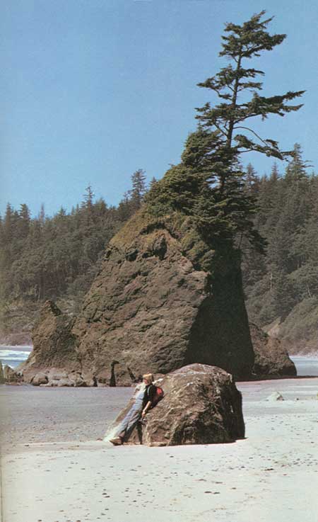
The major zone of chaotically arranged melange Hoh rocks, exposed both in Mosquito Creek and along the coast to the south, continues northward for 2 miles to the mouth of Goodman Creek (fig. 25). Along this coastline the instability of melange rock cliffs is demonstrated almost continuously by landslides. Broken and sheared sandstone and some conglomerate dominate the rock type of these outcrops. Resistant blocks of various sizes eroded from the melange are scattered along the beach, and a few very large ones form offshore rocks (back cover photo). One of these blocks, resting on the beach about 1 mile north of Mosquito Creek (fig. 39), is of an unusual composition for the area. It is composed of angular fragments of volcanic and sedimentary rock that have been welded together to form a solid rock mass known as a BRECCIA. This rock type differs from a conglomerate by being composed of angular fragments of rock rather than rounded rock pebbles. The largest and most prominent single block exposed along this beach consists of massive sandstone and forms a small nearshore island about three-fourths of a mile south of Goodman Creek (fig. 41).
|
| EXOTIC BRECCIA BLOCKS, eroded from the Hoh melange, rest on the beach 1 mile north of Goodman Creek. They are composed of angular fragments of volcanic and sedimentary rocks, a rock type foreign to Hoh sedimentary rock sequence (fig. 39). |
|
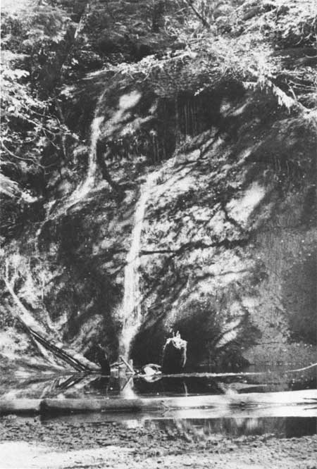
| FALLS CREEK tumbles over a 50-foot-high conglomerate cliff before merging with Goodman Creek (fig. 40). |
|
| SINGLE SANDSTONE BLOCK from tectonic melange forms a small nearshore island three-fourths of a mile south of Goodman Creek (fig. 41). |
HISTORICAL NOTES
GOODMAN CREEK VALLEY
Goodman Creek, once called "Kek-chen-whilt" River (Davidson, 1889) is the major drainage between the Hoh River to the south and the Quillayute River to the north. Together with its tributaries, Goodman Creek drains an area of over 30 square miles extending eastward to the Bogachiel drainage. Falls Creek, a major tributary from the north, descends suddenly into Goodman Creek near its mouth over a 50-foot conglomerate cliff (fig. 40). Minter Creek, also a sizable tributary, drains from the south and east and enters Goodman Creek about 4 miles upstream from the coast.
For the natives and early settlers, Goodman Creek valley served as an avenue of access to coast from the Bogachiel Valley some 10 miles to the east. Remains of their old trail is still visible in places. Although their buildings are essentially gone, the area is marked by the telltale evidence of large, "high cut" stumps with springboard notches barely visible, together with small patches of second-growth timber growing where a clearing was once made in the virgin forest.
The broken rock debris exposed along the coast between Jefferson Cove and Goodman Creek forms a north-trending belt that, in places, extends inland nearly a mile (fig. 25). This belt of outcrops is believed to expose a large segment of a major THRUST FAULT zone—the contact area between two major segments of the earth's crust, one of which has been thrust beneath the other (Rau, 1979). The melange rocks of the Hoh-Goodman Creek coastal area are therefore believed to be the resulting rock debris formed by the grinding of one crustal plate beneath another (see Tectonic Melange Rocks, Part I).
| <<< Previous | <<< Contents >>> | Next >>> |
state/wa/1980-72/sec2-4.htm
Last Updated: 28-Mar-2006