
|
Washington Department of Natural Resources Geology and Earth Resources Division Bulletin No. 72 Washington Coastal Geology between the Hoh and Quillayute Rivers |
PART II
GEOLOGIC OBSERVATIONS AND INTERPRETATIONS ALONG THE COAST
(continued)
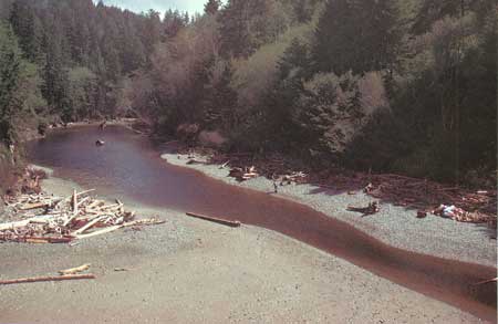
MOSQUITO CREEK
Mosquito Creek, once called Chah-latt Creek, drains some 20 square miles that lie between the Hoh River and Goodman Creek to the north (fig. 36). Its three main branches, one from the south, one from the southeast, and the main fork from the northeast, all converge within a mile of the coast (fig. 24).
|
| MOSQUITO CREEK drains some 20 square miles that lie between the Hoh River and Goodman Creek (fig. 36). |
For nearly a mile Mosquito Creek flows over a zone of melange rocks before reaching the coast. These rock materials are a continuation of those chaotically arranged rocks seen along the coast both to the south and north of Mosquito Creek (fig. 25). The stream course through this zone is especially crooked and in places nearly doubles back on itself. This course has resulted from the stream cutting down and through an area where large resistant blocks of sandstone occur randomly within the unit of rock melange. A course of least resistance has been taken by the stream around the large sandstone blocks. This melange zone extends inland nearly to the convergence of the middle fork from the southeast with the main branch from the northeast. From this point upstream along both the middle fork and main branch, the stream flows over a bedrock of steeply dipping, bedded sandstone with thin beds of siltstone. These rocks are particularly well exposed in the middle fork where the stream flows generally across the steeply dipping strata. Although they are contorted and steeply dipping and in places even overturned, these rocks are structurally coherent. They constitute a continuation of the strata exposed farther south along the coast that forms the west limb of the anticlinal structure.
ALEXANDER ISLAND
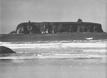
Alexander Island, located a mile due west of Mosquito Creek, is the largest offshore rock mass exposed between the Hoh and Quillayute Rivers (fig. 37). This relatively long, narrow flat-topped island is slightly more than a quarter of a mile in length but its greatest width is only about 550 feet, and it stands about 120 feet in height above sea level. Its length is best viewed from the beach in the area between Mosquito Creek and Goodman Creek, and its width is best seen from a point about a mile south of Mosquito Creek. Its nearly flat surface is densely covered with brush of about equal height with the exception of two scrubby trees, one on the south end and the larger near the northern end. The dense bird population has deposited a white coating on much of the rock surface, largely exposed on the west side of the island (fig. 38).
|
| ALEXANDER ISLAND is the largest offshore rock mass between the Hoh and Quillayute Rivers. It is an erosional remnant of Hoh sandstone. An ancient elevated wave-cut platform is marked by the base of the vegetation. Pleistocene sand and gravel rest on this surface (fig. 37). |

|
| SOUTHWEST SIDE OF ALEXANDER ISLAND. The white coating on the rocks is indicative of a large bird population (fig. 38). |
Alexander Island is mostly massive sandstone but with a few stratified beds cropping out in several areas. On the southern end of the island, strata trend in a northwest direction, generally parallel to the length of the island, and dip steeply to the southwest. Bedded sandstones are also exposed on the northern end of the island, but there the trend is nearly east-west with dips moderately to the south.
The upper surface of bedrock, although capped with some 20-foot thickness of unconsolidated material, is also generally flat. This surface is a remnant of an extensive elevated wave-cut terrace, the trace or actual surface of which may be seen in many places on the mainland and on offshore rock masses. This terrace surface was carved when the sea stood higher relative to the land. The sea also extended farther eastward or inland in places than it does today.
The upper 20 feet of the island is composed of unconsolidated silts, sands, and gravels—materials that were brought from the Olympic Mountains to nearby coastal areas by glacial ice during a late part of the Pleistocene Epoch. These rock materials were further distributed to their present position by melt water from the glaciers. At that time the coastal area was a broad, recently uplifted wave-cut terrace and it extended westward far beyond Alexander Island of today. Over the last few thousand years and since the terrace was blanketed with unconsolidated sediments, the sea, at a lower level, has continued to erode this broad, relatively flat-surfaced land area, moving the coastline slowly eastward to its present position. Alexander Island, with its massive and particularly resistant rock foundation, preserves locally at least the westernmost remnant of this old nearly flat land surface.
| <<< Previous | <<< Contents >>> | Next >>> |
state/wa/1980-72/sec2-3.htm
Last Updated: 28-Mar-2006