
|
Geological Survey Professional Paper 387—B
Recent Activity of Glaciers of Mount Rainier, Washington |
TABLE OF CONTENTS
Introduction
Purpose and scope
Methods, documentation, and terminology
South Tahoma and Tahoma Glaciers
South Tahoma Glacier
Tahoma Glacier
Emerald Ridge, Tahoma Glacier
Summary, South Tahoma and Tahoma Glaciers
Emmons Glacier
Summary, Emmons Glacier
Significance of dated moraines, channels, and melt-water deposits
Hydrologic inferences
Summary of moraine ages
|
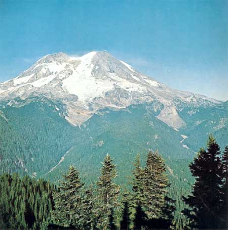
| FRONTISPIECE.—Tahoma Glacier, shown here at left center of the photograph, cascades down the west slope of Mount Rainier where it forms the headwaters of South Puyallup River. South Tahoma Glacier rises on the side of Mount Rainier to the right, flows around a bedrock hill and terminates in a gray tongue of ice from which Tahoma Creek flows off to the right. The bare valley bottoms just below the termini were covered by the glaciers less than 60 years ago. (Photograph taken from Gobbler's Knob, September 20, 1967.) |
ILLUSTRATIONS
[Plates 1—7 are in separate volume]
COVER. View of Mount Rainier northwestward up Cowlitz River valley from west slope of Backbone Ridge.FRONTISPIECE. Tahoma Glacier cascades down the west slope of Mount Rainier.
PLATE (omitted from the online edition)
2—7. Map and photographs:
2. Nisqually River valley near Nisqually Glacier terminus.3. Tahoma Creek valley, South Puyallup River valley, and Emerald Ridge near South Tahoma and Tahoma Glaciers.
4. North Puyallup River valley near Puyallup Glacier.
5. Carbon River valley near Carbon Glacier terminus.
6. West Fork and Winthrop Creek valleys near Winthrop Glacier terminus.
7. White River and Inter Fork valleys near Emmons Glacier terminus.
FIGURE
2—8 Photographs:
2. Trees are sampled at the lowest possible level3. South Tahoma Glacier and Tahoma Glacier joined in 1910 below Glacier Island
4. Junction of Tahoma Creek Trail and Wonderland Trail
5. The 1835—50 lateral moraine of South Tahoma Glacier
6. The 1840 moraine and the older surface
7. Tahoma Glacier covered the rocks as recently as 1860
8. Wonderland Trail follows the narrow ridge above South Puyallup River
9. Cross-sectional diagrams drawn along lines through two melt-water channels
10. Map—In 1896, White River drained Emmons Glacier as it does today but had two tributaries flowing through the moraines
11—13. Photographs:
11. The bare amphitheater holds immobile ice that was once part of Ohanapecosh Glacier12. Oblique aerial view of Ohanapecosh River valley near Ohanapecosh Glacier
13. Trees closest to Ohanapecosh Glacier
TABLES
TABLES
1—9. Ages of trees sampled from periglacial features near—
1. Nisqually Glacier2. South Tahoma Glacier
3. Tahoma Glacier
4. Emerald Ridge
5. Puyallup Glacier
6. Carbon Glacier
7. Winthrop Glacier
8. Emmons Glacier
9. Ohanapecosh Glacier
10. Ages of glacial or pyroclastic deposits at Mount Rainier, Washington
UNITED STATES DEPARTMENT OF THE INTERIOR
ROGERS C. B. MORTON, SecretaryGEOLOGICAL SURVEY
V. E. McKelvey, Director
| <<< Previous | <<< Contents >>> | Next >>> |
pp/387-B/contents.htm
Last Updated: 28-Mar-2006