
|
Geological Survey Professional Paper 387—B
Recent Activity of Glaciers of Mount Rainier, Washington |
SOUTH TAHOMA AND TAHOMA GLACIERS
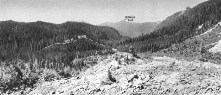
South Tahoma and Tahoma Glaciers (fig. 4 and map on pl. 3), descending the west slope of the volcano, are separate throughout most of their lengths. The two glaciers were, however, connected at altitudes between 7,500 and 8,500 feet in 1967 (M. F. Meier, U.S. Geological Survey, written commun., 1967). One fork of Tahoma Glacier also joined South Tahoma Glacier at about 5,000 feet in altitude (fig. 3) until sometime after 1910. (See also Mount Rainier National Park topographic map, U.S. Geological Survey, 1910 (revised 1955)). Because of these interconnections now and in the past, one might expect the two glaciers to behave similarly; however, South Tahoma left two datable moraines, whereas Tahoma left three, only one of which has a South Tahoma counterpart. This moraine is referred to as the 1835-40 moraine; for these two glaciers, as well as Nisqually and Puyallup Glaciers, the moraine of this approximate date is the most extensive of any that was dated. Moraine segments of this age were also found at Carbon, Emmons, and Ohanapecosh Glaciers.
|
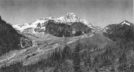
| FIGURE 3.—South Tahoma Glacier (ST) and Tahoma Glacier (T) joined in 1910 below Glacier Island (GI) and extended out of view to the lower left. July 15, 1960. |
SOUTH TAHOMA GLACIER
South Tahoma Glacier (figs. 5 and 6 on pl. 3, frontispiece) was an extensive and almost as far downvalley in 1840 as it was in 1550. During these two periods, the glacier formed moraines about 2 miles east of the former site of Tahoma Creek Camp ground.
The Tahoma Creek trail meets the Wonderland Trail (fig. 4) at the front of the outermost end moraine. Southward the Wonderland Trail, toward Indian Henry Hunting Ground, climbs steeply from Tahoma Creek across the terminal moraine (fig. 5) before it passes into the old forest along the stream draining Mirror Lakes.
|
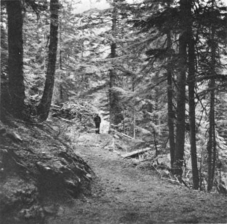
| FIGURE 4.—From its junction with Tahoma Creek Trail in the immediate foreground, Wonderland Trail leaves the 1550 moraine and crosses the 1840 moraine where the man is standing. View from area 16 looking toward area 18, taken on Sept. 9, 1967. |
|
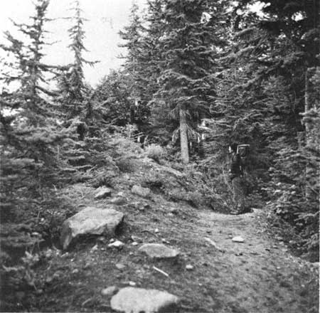
| FIGURE 5.—The 1885-50 lateral moraine of South Tahoma Glacier is seen here where Wonderland Trail crosses it before entering the old forest. The men are standing on the moraine; the man on the left is on the crest, the other is standing near the edge of the old forest. Sept. 14, 1967. |
Northeastward from the trail junction, the Wonderland Trail follows a prominent lateral moraine toward the nose of Emerald Ridge (fig. 6) or is just below it for another half-mile. At a switchback, the trail crosses the moraine to enter the old forest; farther on it rejoins the lateral moraine.
|
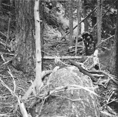
| FIGURE 6.—The small boy in the center is standing in the gully between the 1840 moraine (area 18) on the right and the older surface on the left. Wonderland Trail is to the right about 25 feet downslope from the moraine. July 8, 1961. |
A short segment of moraine marking an old position of the glacier front lies at the junction of Tahoma Creek Trail and Wonderland Trail on top of a cliff above Tahoma Creek. The oldest of eight trees cored here was 3 feet, 5 inches tall in A.D. 1528, and others were about that size within a few years; so the advance that formed this moraine ended not later than the early part of the 16th century.
The most prominent moraine of South Tahoma Glacier rests along both sides of the valley upon which trees started to grow between about 1835 and 1860. This moraine was pushed there by the glacier after it overrode in most places all older moraines. The moraine is plastered against the upvalley edge of the 1550 moraine. Ice started to recede from the extensive moraine about 1840 and has been receding nearly ever since, but at a variable rate. Maximum ages of trees in several places on post-1840 morainal ridges suggest that the glacier readvanced a short distance before 1860 and had receded from areas 13, 10, and 5 by about 1860 (table 2).
TABLE 2.—South Tahoma Glacier: ages of trees sampled from periglacial features
[Periglacial feature: OS, old surface; M, moraine; OM, old moraine; OW, outwash]
| Sample area | Number of trees sampled |
Year (A.D.) represented by inner ring of oldest cored tree |
Periglacial feature |
| 18a | 1 | 1778 | OS |
| 17a | 1 | 1558 | OS |
| 14a | 3 | 1616 | OS |
| 6 | 1 | 1860 | OS |
| 1 | 2 | 1609 | OS |
| 16 | 7 | 1528 | OM |
| 20 | 2 | 1877 | M |
| 18 | 6 | 1845 | M |
| 14 | 8 | 1843 | M |
| 19 | 6 | 1848 | M |
| 7 | 1 | 1855 | M |
| 4 | 9 | 1861 | M |
| 3 | 13 | 1849 | M |
| 2 | 10 | 1843 | M |
| 10 | 7 | 1862 | M |
| 11 | 5 | 1878 | M |
| 17 | 4 | 1868 | M |
| 15 | 2 | 1863 | M |
| 13 | 2 | 1863 | M |
| 5 | 6 | 1863 | M |
| 8 | 8 | 1864 | M |
| 9 | 8 | 1871 | M |
| 21 | 1 | 1904 | M |
| 12 | 1 | 1882 | OW |
The smaller trees south of the moraine between areas 2 and 7 probably are younger than the older trees at area 1. Because they lie outside the moraine, their relative youth (started to grow about 1860), however, is not readily explained. Only one tree was sampled in this forest of smaller trees (area 6), thus the surface cannot be accurately dated. It is possible that the trees started to grow about 1860 and date the cessation of drainage of a small melt-water pond bordering the ice. Wonderland Trail passes through this stand of young trees beyond area 2 (map and fig. 6 on pl. 3).
TAHOMA GLACIER
In the 1830's, Tahoma Glacier (map on pl. 3, frontispiece) was more than a mile farther down valley than it is today. The ice front towered 300 feet above the present level of Puyallup River, a mere 200 feet from the trail bridge. At least once before, nearly 400 years ago in the early 1600's, Tahoma Glacier was as extensive as it was early in the last century (map, figs. 3, 5 on pl. 3).
The 1835-40 moraine (dated by tree ages from 14 sample areas) is not prominent where Wonderland Trail crosses it about 100 yards east (upvalley) of the South Puyallup River Trail junction. South of the trail, the valley sides are steep; any moraine once here has since slumped to the valley bottom. From the trail to the South Puyallup River, the moraine consists of a low ridge of boulders that trends down valley. Upslope from the trail the moraine is conspicuous in the forest and, except for a few gaps, can be followed nearly three quarters of a mile along the south side of the valley from area 10 to area 31 (map, figs. 3, 5 on pl. 3).
About 75 feet upslope from the point at which the 1835-40 moraine crosses the Wonderland Trail (map, figs. 3, 5 on pl. 3), two roughly parallel moraines may be seen (Sigafoos and Hendricks, 1961, fig. 15). The northern ridge is the 1835-40 moraine. The southern ridge is an older moraine; trees on it are conspicuously larger, and the oldest tree (area 14, table 3) started to grow before A.D. 1629. Most of the remainder of the older moraine represented by this segment was destroyed by a more recent glacial advance and by stream erosion and avalanches. Only two other segments have been found, at areas 19 and 34. The oldest tree on the moraine at area 34 started to grow before 1623; therefore, Tahoma Glacier receded from this position early in the 17th century.
TABLE 3.—Tahoma Glacier: ages of trees sampled from periglacial features
[Periglacial feature: OS, old surface; M, moraine; OM, old moraine; YM, young moraine; OW, outwash]
| Sample area | Number of trees sampled |
Year (A.D.) represented by inner ring of oldest cored tree |
Periglacial feature |
| 32 | 1 | 1681 | OS |
| 20a | 1 | 1589 | OS |
| 8 | 3 | 1622 | OS |
| 15 | 3 | 1544 | OS |
| 19 | 4 | 1676 | OM |
| 7 | 6 | 1640 | OM |
| 14 | 2 | 1629 | OM |
| 34 | 4 | 1623 | OM |
| 39 | 4 | 1788 | M |
| 40 | 2 | 1777 | M |
| 41 | 6 | 1761 | M |
| 42a | 3 | 1839 | M |
| 31 | 12 | 1844 | M |
| 22 | 3 | 1843 | M |
| 21 | 3 | 1845 | M |
| 20 | 8 | 1852 | M |
| 18 | 6 | 1847 | M |
| 17 | 10 | 1849 | M |
| 16 | 5 | 1844 | M |
| 13 | 5 | 1866 | M |
| 12 | 9 | 1844 | M |
| 11 | 7 | 1844 | M |
| 6 | 10 | 1841 | M |
| 9 | 8 | 1858 | M |
| 10 | 5 | 1851 | M |
| 35 | 4 | 1851 | M |
| 36 | 3 | 1859 | M |
| 52 | 7 | 1855 | M |
| 51 | 6 | 1862 | M |
| 4 | 11 | 1861 | M |
| 5 | 7 | 1857 | M |
| 57 | 10 | 1863 | M |
| 58 | 11 | 1852 | M |
| 44 | 4 | 1873 | OW |
| 43 | 4 | 1868 | OW |
| 60 | 4 | 1862 | OW |
| 24 | 3 | 1870 | M |
| 23 | 3 | 1862 | M |
| 56 | 10 | 1866 | OW |
| 59 | 10 | 1853 | OW |
| 42 | 7 | 1904 | YM |
| 45 | 8 | 1909 | YM |
| 37 | 5 | 1907 | YM |
| 46 | 6 | 1900 | YM |
| 47 | 6 | 1898 | YM |
| 48 | 2 | 1915 | YM |
| 49 | 11 | 1909 | YM |
| 50 | 10 | 1912 | YM |
| 55 | 4 | 1914 | OW |
| 54 | 6 | 1910 | OW |
| 30 | 3 | 1944 | OW |
| 29 | 6 | 1935 | OW |
| 28 | 4 | 1927 | OW |
| 27b | 5 | 1925 | OW |
| 27a | 2 | 1944 | OW |
| 26 | 7 | 1918 | OW |
Since about 1835, Tahoma Glacier has been shrinking, and although minor advances may have produced small morainal ridges, erosion and deposition destroyed or buried them, so that precise ice positions in the last century cannot be determined. The trail between the small stream (south of area 50) and areas 46-45 crosses gravel and boulder fields (fig. 7) deposited by water emerging from the ice when the glacier filled the valley eastward from a line between areas 27a and 45. The lines representing the ice margins in 1860 and 1910 are only approximately located; however, the glacier could not have been farther downvalley than the lines indicate because trees at sample areas 49 and 50, downvalley from the 1910 line, started growing before 1909 and 1912. Those at areas 4 and 5, downvalley from the 1860 line, started to grow before 1861 and 1857.
|
| FIGURE 7.—Tahoma Glacier covered the rocks in the foreground and filled the lowland of South Puyallup River to the left of and just beyond gravel and boulders as recently as 1860. About 1835-40, Tahoma Glacier started to recede from area of the dashed line. |
East of area 42 (fig. 2 on pl. 3), the trail follows a knife-edged ridge flanked by the Puyallup River on the north and a steeply sloping, gravel-floored valley on the south (fig. 8). To the southwest in the narrow open valley, morainal ridges (areas 39, 40, and 41) remain at the base of the hill. Tree ages at these areas suggest that the glacier tongue that extended down this valley started to recede about 1760.

|
| FIGURE 8.—Wonderland Trail follows the narrow ridge extending from the trees in the right foreground to margin of photograph at the right. Tahoma Glacier extended down the steeply sloping valley on the left and formed a moraine which is out of sight. On the left the open valley supporting small scattered trees is floored with gravel deposited before 1865. This gravel was eroded by melt water between 1865 and 1910. |
Bouldery material was deposited in the same narrow valley by streams flowing from the side of Tahoma Glacier until about 100 years ago. The bouldery deposit is exposed in two deep gullies ad joining areas 43 and 44, which were eroded between about 1865 and 1910. During this interval a gravel and boulder fan (areas 54 and 60) was built just southwest of the camera point of figure 8. Flow of glacial melt water and deposition of gravel stopped about 1910 and permitted trees to grow in the channels. Melt water through this valley between about 100 and 60 years ago ceased or markedly declined in volume; otherwise the trees at areas 43, 44, and 60 would not have started to grow a little more than 100 years ago. Flow began again or continued at a low volume until about 60 years ago, when melt water from the glacier ceased completely.
The various moraines shown on plate 3, the trees, their ages, and deposits at areas 43, 44, 54, 55, and 60 suggest the following sequence: (1) A glacier advance that formed a moraine from which the glacier started to recede about 1625; (2) a readvance followed by a recession that started about 1760; (3) another glacier advance that formed the 1835-40 moraine; (4) recession from this moraine during which melt water deposited material to the southwest at areas 43, 44, and 60; (5) cessation of or marked decrease in melt-water flow southwestward which permitted the trees to become established at areas 43, 44, and 60 about 1860; (6) continued low flow of melt water southwestward that eroded the two gullies and deposited the gravel and boulders at areas 55 and 54; and (7) cessation of flow because the melt-water outlet receded below the narrow ridge (fig. 8) and permitted trees to start growing shortly before 1910 at areas 54 and 55.
EMERALD RIDGE, TAHOMA GLACIER
Tahoma Glacier splits into one arm that plunges down South Puyallup River valley and into a smaller arm that extends southwestward toward Tahoma Creek valley (map and fig. 4 on pl. 3; fig. 3). The southwestward-trending arm left several prominent moraines on the east side of Emerald Ridge where Wonderland Trail descends into Tahoma Creek valley (map and fig. 1 on pl. 3). The glacier started to recede from these moraines before 1850.
The moraines here are between 5,000 and 5,400 feet above sea level and close to timberline. The time between the start of glacier recession and seedling establishment at timberline may well be longer than the 5 to 10 years estimated for moraines at lower-elevations (Sigafoos and Hendricks, 1969). At Emerald Ridge, the date when South Fork Tahoma Glacier receded from the moraines is not known and how much time passed before seedlings started to grow cannot be determined. Thus, although the ages of the oldest trees on the Emerald Ridge moraine differ between areas, the age differences do not necessarily mean that the forest in area 22, for example, is younger than in areas downvalley, such as area 65b (table 4). Some trees are younger than others, but the moraine probably is one age.
TABLE 4.—Emerald Ridge: ages of trees sampled from pereglacial features
[Periglacial features : moraines]
| Sample area | Number of trees sampled |
Year (A.D.) represented by inner ring of oldest cored tree |
| 22 | 5 | 1871 |
| 33 | 2 | 1866 |
| 65a | 1 | 1886 |
| 65b | 9 | 1857 |
| 65c | 3 | 1863 |
The tree ages at Emerald Ridge show that South Fork of Tahoma Glacier in 1850 could not have extended beyond the moraine which the trail parallels. Apparently the glacier started to recede from this moraine, the highest on the slope, when Tahoma and South Tahoma Glaciers began to recede around 1835-40. If this is true, then the lag between glacier retreat and seedling establishment at timberline is from 15 to 35 years.
A melt-water stream flowing from the west side of the south arm of Tahoma Glacier to Tahoma Creek eroded a deep gully diagonally across part of the 1850 moraine (between areas 33 and 65a). Because the stream eroded part of the moraine, the gully and the gravelly debris along the trail in the open valley north of area 22 are younger than the moraine.
SUMMARY, SOUTH TAHOMA AND TAHOMA GLACIERS
Approximate dates that South Tahoma and Tahoma Glaciers started to recede, including the date for glacier arm below Emerald Ridge, are summarized in the following table:
Age of moraines, A.D.
| South Tahoma | Tahoma | Emerald Ridge |
| 1520 | — | — |
| — | 1620 | — |
| — | 1755 | — |
| 1835 | 1835-40 | 1850 |
The variety of moraines and their ages show that one cannot correlate glacier retreats closely without precise information on morainal ages.
| <<< Previous | <<< Contents >>> | Next >>> |
pp/387-B/sec2.htm
Last Updated: 28-Mar-2006