
|
Geological Survey Professional Paper 387—B
Recent Activity of Glaciers of Mount Rainier, Washington |
INTRODUCTION
Gleaming snow and glacial ice on the upper slopes and the deep forests on lower hills and narrow valleys are the dominant features of the imposing landscape that is Mount Rainier volcano, Wash. (frontispiece). The glaciers have scoured the valleys repeatedly and have left well-formed moraines and scattered gravel deposits to mark their past positions. The ages of trees growing on these landforms record the sequence of formation of the landforms. Ideal growing conditions at elevations far below timberline allow tree seeds to germinate within 1 to 16 years after the ice has melted from a moraine or after melt water has ceased to flow across gravel deposits. Hence, the age of the oldest trees on a landform is reliable evidence of the landform's minimum age.
Melt water from glaciers of Mount Rainier and other mountains is used for hydroelectric power, and glaciers in some places pose a threat to works of man. An understanding of past glacier activity and mechanism of ice movement, therefore, has considerable economic importance in providing an understanding of fluctuating water supplies. In addition, as advance and retreat of glaciers is related to climate, knowledge of the past behavior of glaciers allows inferences to be drawn about past climatic variations.
Inferences about fluctuations in climate cannot be made from the observed sequences of past glacier activity because adjacent glaciers may not necessarily respond similarly to climatic fluctuations. End and lateral moraines from which glaciers started to recede just before 1835-40 may have climatic significance when more is learned about glacial response to climate. Moraine segments of this age were found downvalley from seven of eight glaciers studied. Below Nisqually and Tahoma Glaciers moraines of this age represent advance farther downvalley than at any other time in the last 10,000 years.
PURPOSE AND SCOPE
Since our initial reconnaissance work (Sigafoos and Hendricks, 1961), we have studied the young moraines below five additional glaciers and more areas on moraines below the three glaciers reported earlier. This report, which primarily documents our work to date, shows sample areas, moraines, and a few other periglacial features on aerial photographs and planimetric maps, presents summaries of our data, and discusses the significance of ages of trees on certain landforms. Each glacier is discussed in turn clockwise around Mount Rainier, starting with Nisqually Glacier (p1. 1). Additionally, the work is so documented that future investigators may visit the sites and observe the changes that passing years have brought about. We hope that the report will help the interested person understand some of the periglacial features that he sees along the trails and from some vantage points along the roads that overlook the major glaciers. The folded maps in the case present a summary of data about each glacier.
METHODS, DOCUMENTATION, AND TERMINOLOGY
The methods used in this study have been previously reported (Sigafoos and Hendricks, 1961), but several underlying premises and details of the methods need to be emphasized. One of the most important, and at the same time most overlooked, facts is the significance of living plants in the environment. Plants will grow in every environment unless some force prevents them from growing. The force may be related to climate, such as hot, dry conditions prevalent in deserts, or the perennial snowfields on mountain tops. It may be the physical power of glaciers, of flowing water, or of movement of rock and soil in landslides or by frost heaving. It may be fire, or it may be man's activity. It may even be passive by being related to space; for example, a large area may be denuded of forest by fire, and much of the area may be too remote for seed to travel from sources in living trees and other plants. Thus, if plants are not present at certain places in areas where plant cover is otherwise generally complete, then some force is keeping the plants from growing.
We worked in areas of moraines, outwash, and flood plains in the bottoms of densely forested canyons. These environments are ideal for the germination and growth of trees. Physical instability of moraines that results from the melting ice plus the scour of alluvium and moraines by flood and melt water are the primary forces that prevent survival of seedlings. Once these forces disappear, trees will become established in 1 to 16 years (Sigafoos and Hendricks, 1961, p. A13). This period was established by determining the ages of trees on surfaces whose date of formation is known from other evidence (Sigafoos and Hendricks, 1969).
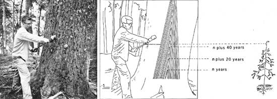
The age of a tree is estimated from a count of annual rings in a section or a core extracted from a tree with an increment borer (fig. 1). The 3/16 inch-diameter core is then placed in a special clamp, cut across the grain with a razor-sharp knife, and rings counted. The age, species, sample number, core height, and trunk diameter are recorded. Back in the office annual rings in each core are again counted.
|
| FIGURE 1—Top: Samples can be taken from larger trees no closer than 2-3 ft above the ground; so the error in age determination is equal to the age of a small tree 2-3 ft tall and may be as much as 50 years. This 43.4 in. western hemlock was 4 ft tall in A.D. 1542 and is growing on an old Carbon Glacier moraine, area 8 (fig. 1 on pl. 5). Bottom: Each annual ring, seen here diagrammatically in vertical section, consists of an elongated cone; the trunk is composed of ever-larger cones superimposed one upon another. The upper tip of each cone was once the tip of a small tree and, with the cone, remains in the same position throughout the life of the tree. Each line represents the tree shown in the photograph as it probably appeared in A.D. 1542. |
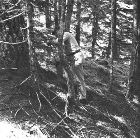
By sampling several trees of each species at a locality, the authors were able to identify the probable oldest tree at that locality. By sampling at many localities, we are able to plot ages of the oldest trees on a map. Lines then are drawn to connect points with similar ages; thus, positions of the glaciers during several periods in the last 600 years are shown. In the study, a total of 1,373 trees were cored. A diligent attempt was made to include the center ring of each tree at a level as close to the ground as possible (fig. 2), and it is the year that this ring grew that is listed in the table. This date is obtained by subtracting the number of annual rings in a complete sample from the number of the year after the outer ring was formed. The next year must be used, for although the last year of growth of a tree is not complete by midsummer, for dating purposes the outer ring and growth year are complete.
|
| FIGURE 2—Trees are sampled at the lowest possible level to determine their age. Carbon Glacier started to recede from here about 1845 (area 11, Carbon Glacier) (fig. 1 on pl. 5). July 17, 1963. |
The error in determining absolute tree ages increases with the size of the tree. The age of the smallest and youngest, up to 3 inches in diameter and 20 to 30 years old, is exact because most of the few trees of this size were already cut, and a section that provides a complete set of rings was taken from the lowest part of the trunk. Other larger trees were cored as close to the base as possible; so the error in age determination of trees up to 2 feet in diameter and 200 years old is probably less than 10 years. Age determinations of these trees are fairly accurate because the age of the oldest trees at different places on nearly continuous moraines is nearly the same. The error in age of trees up to 4 feet in diameter and 400 years old, however, may be as much as 50 years. Core samples cannot be taken easily lower than 2 to 3 feet above the ground because of the length of the borer handle and the physical effort required to core large trees.
Each vertical aerial photograph included in this report shows positions of former ice margins that are marked by prominent moraines or by other field evidence. Positions of significantly different age, generally a hundred years or more, are differentiated by colored lines. Positions marked by lines of the same color on different plates indicate our belief that different glaciers occupied these positions contemporaneously. Prominent ground features can be identified on the photographs unless the features were destroyed since the photograph was taken. With the aerial photographs, the maps, and the ground photographs of selected key places, the interested person can locate himself with reference to moraines and other surface features. The photographs are not orthographically true; that is, the scale of the photograph varies from place to place depending upon the distance between the ground and the aerial camera. This distortion on the photographs accounts for the anomalous curvature of some lines. Measurements made from the photographs, further more, are inaccurate.
The glacier maps, made by photogrammetric methods from 1960 aerial photographs, are believed to be sufficiently accurate for general cartographic measurements to be made from them. They are included, not only to permit measurements to be made, but to identify named features discussed in the report and to show the location of features that may be destroyed in the future by glacier advance or other cause.
The dated lines on the photographs and maps represent the position from which the ice started to recede at the date specified. The dates are derived by adding five years (for seedlings to become established) to the age of the oldest tree and rounding the figure to the next older five years. For example, if the innermost ring of the oldest tree sampled in 1967 grew 121 years ago, then the approximate date the ice began receding is 121 + 5, subtracted from 1968, yielding 1842, rounded to 1840. The interval between the computed date and the present date represents the minimum time that the area has been free of glacial ice.
The periglacial feature designated for each area is a general descriptive name for the site. Some are common terms, but certain features may not be familiar to all readers. Old surface (OS) refers to an area that has not been glaciated for periods as long as 10,000 years. Outwash (OW) is a deposit of the sand, gravel, and boulders left by the melt-water stream emanating from the glacier. Melt-water channel (MWC) is a small valley or gully cut through a moraine by melt water and floored with outwash. Flood plain (FP), as used in this report, is the surface inundated by the glacial melt-water stream once a year or more often.
| <<< Previous | <<< Contents >>> | Next >>> |
pp/387-B/intro.htm
Last Updated: 28-Mar-2006