
|
Geological Survey Bulletin 1393
The Geologic Story of Arches National Park |
GRADUATION TO A PARK
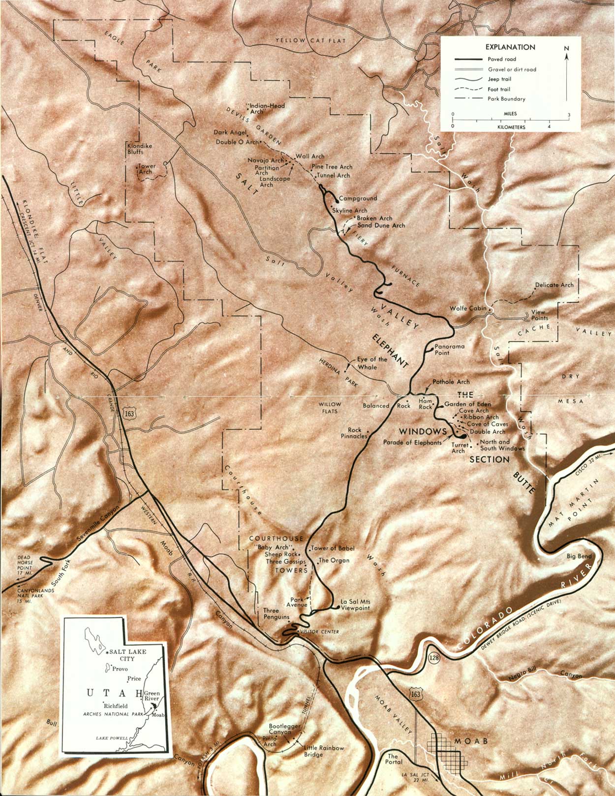
ARCHES GRADUATED to a full-fledged national park when President Richard M. Nixon signed a Congressional Bill on November 16, 1971. The change in status was accompanied by boundary changes that reduced the area to about 114 square miles. The loss of most of Dry Mesa, just east of the present boundary (fig. 1), was offset in part by gains of new land northwest of Devils Garden. The present (1974) boundaries, roads, trails, and named features of the park are shown in figure 1.
The park was virtually completed at graduation time, and so far this change in status has shown up mainly in new entrance signs, a new 1972 brochure and map, and a very informative "Guide to an Auto Tour of Arches National Park," keyed to numbered signs at parking spaces. About all that remain to be added are new wayside exhibits, some boundary fences, and spur roads and trails.
|
| ARCHES NATIONAL PARK (overleaf), showing location in Utah, boundaries, streams, highways and roads, trails, landforms, principal named features, and the city of Moab. The reader is referred to figure 7 and to road maps issued by the State or by oil companies for the locations of other nearby towns and features. Visitors also may obtain pamphlets, from the entrance station or from the National Park Service office in Moab, which contain up-to-date maps of the park and the latest available information on roads, trails, campsites, and picnic sites. (click on image for an enlargement in a new window) (Fig. 1) |
Although Arches had officially become a park in November 1971, it was not formally dedicated until May 15, 1972. The ceremony began by having the Federal, State, and local dignitaries and other guests totaling 140 persons board the Canyon King, a 93-foot replica of a Mississippi River sternwheeler (Lansford, 1972; Lohman, 1974, fig. 69), for its maiden voyage down the Colorado River. After about half an hour, the heavily laden boat became stuck on a sandbar, and after a 90-minute wait the passengers were rescued by jet boats. This delayed a luncheon at the Visitor Center put on by the Moab Lions Club. Following the luncheon, Park Superintendent Bates Wilson made a brief welcoming address, then introduced J. Leonard Volz, Director of the Midwest Region of the National Park Service, who served as master of ceremonies. Speakers included Utah Governor Calvin L. Rampton, Senator Frank E. Moss, a representative of Senator Wallace F. Bennett, Representatives Sherman P. Lloyd of Utah and Wayne Aspinall of Colorado, and Mitchell Melich, Solicitor General of the Department of Interior, representing Secretary Rogers C. B. Morton. After the speeches, a commemorative plaque, donated by the Canyonlands Natural History Association, was unveiled by Senator Moss and Mr. Melich.
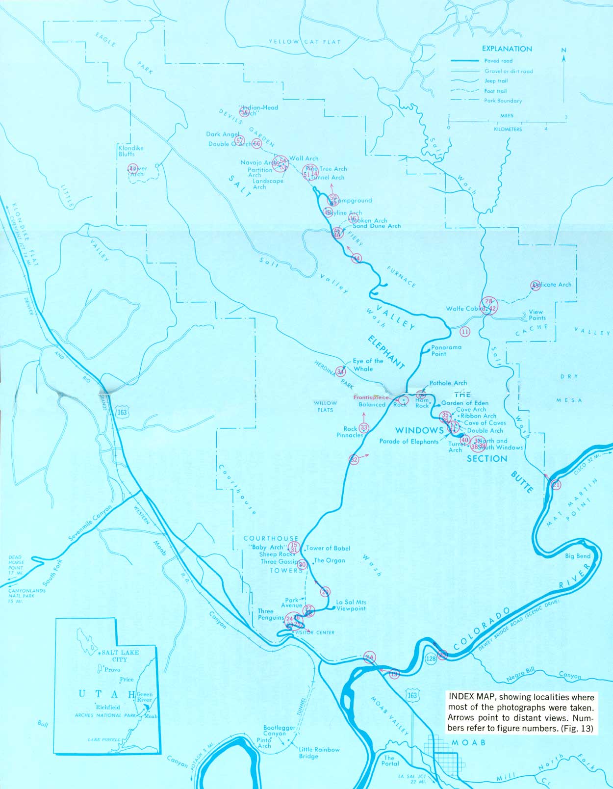
Most of the color photographs were taken by me on 4- X 5-inch film in a tripod-mounted press camera, using lenses of several focal lengths, but a few were taken on 35-mm film, using lenses of various focal lengths. I am grateful to several friends for the color photographs credited to them in the figure captions. The black and white photographs were kindly loaned from the Moab and Arches files of the National Park Service. The points from which most of the photographs were taken are shown in figure 13.
|
| INDEX MAP, showing localities where most of the photographs were taken. Arrows point to distant views. Numbers refer to figure numbers. (click on image for an enlargement in a new window) (Fig. 13) |
| <<< Previous | <<< Contents >>> | Next >>> |
bul/1393/sec2.htm
Last Updated: 8-Jan-2007