
J. Axel - NPS The oldest established volcanics in Parashant occurred in the Grand Wash Trough/Pakoon Basin and were part of the Grand Wash Volcanic Field. While it was active it spawned many huge flows 4 - 6 million years ago. These highly fluid lavas traveled long distances, perhaps tens of miles from vents between Mud Mountain and Pakoon Spring. Some traveled all the way into the Colorado River that had just established itself and began cutting the Grand Canyon. The crumbled remnants of these flows can be seen in the basin. They now makes up a series of lava rock-capped escarpments all throughout the basin. Most of the lava rock in the lower half of the basin has since eroded into the Colorado River. The eruptive vents in the Pakoon Basin are so eroded they are hard to see to the untrained eye. However, a few eruption sites are easily visible. The first is the volcanic neck (see photo at top) at Pakoon Springs. It is the remnant of a large eruption dated to 4.4 to 4.8 million years ago. The next is Olaf Knolls, located just south of the mouth of Hidden Canyon and a mile east of the BLM1007 road on BLM1072. Dated to 4-4.5 million years ago, this eruptive event featured olivine alkali flows. Unlike most of the flows in the Grand Wash Volcanic Field, the Olaf Knolls flows traveled only a mile from the eruptive center. Olaf Knolls also has what appears to be a crater near its center that could have been formed by a phreatic eruption where rising lava heated ground water. This caused the aquifer to flash to steam and blow out the rocks above, leaving a round shallow crater called a maar. During the rainiest periods of the last ice age there is evidence of a small lake in the crater due to the presence of beach sands and mollusk fossils. Downcutting erosion from the nearby stream channel has broken open the western rim of the maar so it can no longer fill with water. It is an easy walk from the 4x4 BLM1072 road to Olaf Knolls. Look for several magma feeder dikes around the high point. To its north at the mouth of Hidden Canyon is a sequence of lava flows that eroded by the Hidden Canyon stream channel. Volcanic activity in the Uinkaret and San Francisco volcanic fields is trending to the east as older eruptions are found on the west side of the local volcanic fields. This is in line with the general southwestward movement of the North American Plate as it slides west over lithospheric zone that spawn eruptions. US Geological Survey links to papers and geologic maps of the Uinkaret Volcanic Field: Geologic Map of Clayhole Wash and Vicinity, Mohave County, Northwestern Arizona - Billingsley (Volcanics north of Mt. Trumbull) Geologic Overview of Clayhole Wash and Vicinity - Billingsley Geologic Map of Part of the Uinkaret Volcanic Field, Mohave County, Northwestern Arizona - Billingsley (Volcanics around Mt. Trumbull and Little Springs) Geologic Overview of Part of the Uinkaret Volcanic Field - Billingsley Geologic Map of the Upper Parashant Canyon and Vicinity, Mohave County, Northwestern Arizona - Billingsley (Includes Mt. Dellenbaugh and the Lower Uinkaret Volcanic field/Grand Canyon) Geologic Overview of the Upper Parashant Canyon and Vicinity - Billingsley 
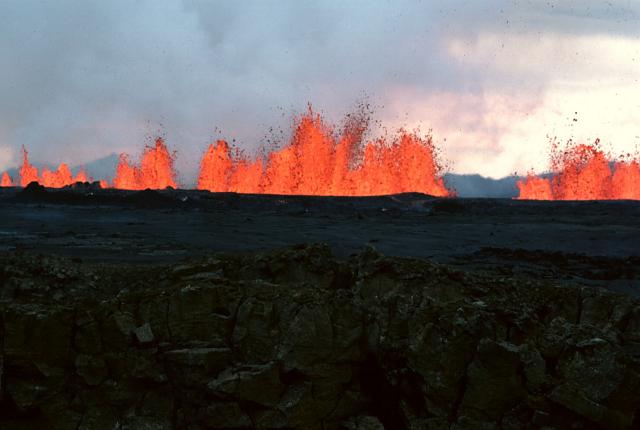
J. Axel - NPS Dramatic Volcanism in Whitmore Canyon 
USGS Depending on how high the lava dams were and how leaky they might be, it took months to a few years to fill one of the lakes after the flow stopped. For perhaps months the Colorado River downstream of Whitmore Canyon would have been dry while the water pooled behind the lava dams. Still, lava dams can be very leaky once they cool. If water was able to work its way though the cooling flow, the water that emerged, at least for many miles, would have been incredibly hot. Meanwhile, only small tributary streams below the lava dam added their meager waters into the river channel. It wouldn't have been until where the Virgin River pours into the Colorado River south of Overton, Nevada, that the Colorado would have flowed again, and that would have been a tiny fraction of its full size. The Virgin only contributes a few hundred cubic feet per second of water, compared to the Colorado River that normally flows at tens of thousands of cfs. For at least a few months the plant and animal life that depended on the river would have been severely impacted. Just think of the repercussions this would have had on the plants and animals downstream in this desert environment, especially the delta wetlands where the Colorado River pours into the Gulf of California. Sections of this vast forest may have died for lack of water. And would the Virgin River and other small tributaries have added enough water for the any water at all to reach the Gulf of California when going through the Mojave Desert in summer where temperatures were over 110 degrees F, or would the water have evaporated long before reaching the Gulf of California? The lake that formed behind the final Whitmore Canyon dam took about a year to fill, eventually stretching 50-100 miles upstream, reaching close to Phantom Ranch. Other lava dams were higher, one was 1,200 feet high at Lava Falls. This may have backed up a lake to the Little Colorado River confluence near Desert View at Grand Canyon National Park. Had one of these lava dams formed in modern times, visitors at the South Rim in Grand Canyon National Park would have looked down on the sparkling waters of a lake in the canyon bottom. Once the lake filled, silt and sand would have built up, slowly filling the reservoir with mud. This would have allowed a large willow and cottonwood forest to grow on newly deposited sediments and along the edge of the lake. If the lava dam lasted over a century, the reservoir would have filled with sand and silt. Once that happened the lake would have transitioned into a wetland and eventually a broad, flat forested plain with the Colorado River meandering slowly toward the top of the lava dam. However, there has not been good evidence found for this hypothesized forest as no lake sediments have yet been identified. The lake evidence so far seems to indicate these lava dam lakes were short lived, lasting maybe a decade or two, with the largest lasting at best a century or two. Evidence from studying the lava flows shows that after lava blocked the river and flowed downstream many miles, eventually the river overtopped or worked its way through the highest part of the dam where the lava poured into the canyon. Keep in mind that while the lava dams were 300-1,200 feet high, downstream of that the lava flows thinned substantially to maybe 50 feet high or less. If river water did work its way through the top of the dam, it would have emerged on the downhill side of the dam then flowed on top of the rest of the flow. Studying the cooling cracks in the lava shows that it the river resumed flowing over the top of the lava while the base of the flow was still cooling. The evidence for this is that the top of the lava flow basalts downstream of dams are made of a jumble of irregularly shaped pieces, called entablature. As basalt cools, it shrinks and cracks. The faster it cools, the more irregular the cracking. If lava cools very slowly, it forms columnar basalt. Some of the lava flows show that the majority of the lava flow is made of entablature, indicating that cooling happened quickly from water quenching rather than air cooling. This indicates that the river resumed flowing over the tops of some of the flows while they were still molten at the bottom. 
NPS - J. Axel Some of the flows traveled a great distance. Of the more recent group, the Lower Black Ledge lava flow was the longest. It traveled at least 75 miles to the end of the Grand Canyon. At that point there is no more evidence for that flow downstream, but since it is so old this may just mean that basalt further downcanyon has simply been washed away or just not been found yet. Based on its rock type matching an eruptive vent at Toroweap, it probably traveled 84 miles if not more. The highest lava dam of all flowed out of Prospect Canyon at Toroweap, creating the Prospect Lava Dam. This happened around 542,000 years ago. The flow was so voluminous that it may have made a lava dam over 2,300 feet high. While still being researched and still very hypothetical, if the Prospect Lava Dam was well sealed, it could have created a lake that stretched clear into Utah hundreds of miles upstream. However, as mentioned before, geologists are troubled by a lack of upstream lakebed deposits that would have been left behind by this hypothesized reservoir. In addition, they have not yet found matching lava rocks on the north side of the Grand Canyon across from Prospect Canyon at Toroweap. Until deposits are found on the north rim across from Prospect Canyon that chemically match the rest of the Prospect flow, geologists can not say this flow blocked the river, or at least didn't block it to the full 2,300 foot level. This means that perhaps the lava flow pooled to a depth of 2,300 feet in Prospect Canyon but the final dam was much lower, resulting in a smaller reservoir. Research is ongoing by the US Geological Survey to examine this question. Lava makes for a weak dam even if it filled the bottom of the canyon and then stretched miles downcanyon like a huge plug. The reason a lava dam is not as strong as concrete is because when intensely hot lava hit water, it flash cooled and transformed into structurally weak pillow basalts, air pockets, hyaloclastite, and a yellow crumbly mineral called palagonite, all of which are made of water-quenched fragmented lava. Basalt cracks when it cools, adding yet more instability to the dam. As water forced its way through or over the unstable dam, the fine grained clays and lava fragments would erode away first, leaving voids. In particular, during the glacial periods of the ice age, the Colorado River was several times its current volume of 20-30,000 cfs. During the last ice age, annual spring runoff routinely exceeded 250,000 cubic feet per second in some years. For comparison sake, 250,000 cfs is the volume of the Columbia River. This vastly increased its ability to destroy lava dams compared to what we see today. As the river flowed over and through a lava dam, it would have made a series of dramatic cascades where crashing water broke away bits of basalt from the end of the flow. This created a receding waterfall cataract that slowly eroded upstream, dismantling the lava flow. Niagara Falls is a good example of a modern receding waterfall where cascading water erodes the precipice from below, weakening the lip of the waterfall until it breaks off. Once it washes downstream, the falling water erodes more rock behind the waterfall, the next lip collapses, and so on. This constant collapsing action makes the waterfall precipice retreat upstream. All of these erosive forces conspired to weaken each lava dam to the point of failure. At some point the lava rock would have been washed away, leaving only the two edges of the lava flow clinging to canyon walls on both sides as the river runs between them. Once a lava dam is fully breached, at least some of the dams failed catastrophically. In the reservoir itself the quickly falling water level immediately begins to cut a deep gorge in the loose material that had been deposited at the upstream end of the reservoir. The new forests growing on the sediments would have been devastated by the lava dam failure. It likely took only a few hours for the river to rip through the sediment. Landslides started all along the Grand Canyon taking cottonwood and willow trees into the churning water. The landslides happened because the water in those lakes that had been pushing out against the sedimentary rocks of the canyon walls was now gone. This causes the slopes to slide. The floodwaters were full of trillions of rocks rolling along at high speeds. Called 'tractive bedload,' the bottom of the flood was as much rolling boulders as it was water. River-rounded limestone rocks have been found mixed with sand and gravel far downstream. Only a huge outburst flood could have eroded angular boulders into rounded ones and rolled them far from where they used to be. Just think about the debris roaring right past Whitmore Canyon from trees to animals, silt, sand, gravel, and giant boulders. They all would have washed out of the Grand Canyon in dramatic fashion. After the deluge, the river resumed its normal flow and life could return to normal, at least until the next dam formed and the process repeated. As time passed, the old lava rock boulders broke off and fell into the river. This created the adventurous rapids like Lava Falls that raft trips navigate today. Will there be more eruptions and lava dams? Probably. The Uinkaret Plateau remains volcanically active. A new eruption could happen at any time. The Lava Falls flow at Vulcans Throne at Toroweap dropped its lava in the river about 72,000 years ago. More eruptions are inevitable, but it could be thousands of years before the next eruption adds its fiery decoration to this landscape. Looking at the dated lava flow layers, it seems that volcanic activity comes in pulses. There has been a 72,000 year lull since the last giant lava outpouring into the canyon. The last eruption in this volcanic field was only 950 years ago at Little Springs by Mt Trumbull, just a few miles from Whitmore Canyon. While the odds are low, one day people will see lava dam up the Colorado River again. Continue to Section 4 to learn about the most recent eruption in Parashant at Little Springs and when we think the next eruption will happen. If you would like to learn more about Grand Canyon volcanism, information in this section was partially summarized from this free scholarly publication from the Geological Society of America 
NPS - J. Axel 
NPS - J. Axel |
Last updated: February 25, 2020