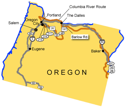
Below are driving directions to follow the Oregon National Historic Trail to Oregon, from Idaho, and along the Columbia River. A simple map showing the general route is below the directions.
To follow the Oregon National Historic Trail to Oregon, from Idaho:
-
Take State Route 20/26 north to State Route 201.
-
Turn west onto State Route 201.
-
Take State Route 201 west to Interstate 84.
-
Turn west onto Interstate 84.
-
Take Interstate 84 west to U.S. Route 197.
-
Turn south onto U.S. Route 197 at The Dalles.
-
Take U.S. Route 197 south to State Route 48.
-
Turn west onto State Route 48.
-
Take State Route 48 west to State Route 35.
-
Turn west onto State Route 35.
-
Take State Route 35 west to U.S. Route 26.
-
Turn west onto U.S. Route 26.
-
Take U.S. Route 26 west to State Route 211.
-
Turn west onto State Route 211.
-
Take State Route 211 west to State Route 224.
-
Turn west onto State Route 224.
-
Take State Route 224 west to State Route 213.
-
Take State Route 213 to Oregon City and the trail's end.
To follow the trail along the Columbia River:
-
Take State Route 20/26 north to State Route 201.
-
Turn west onto State Route 201.
-
Take State Route 201 west to Interstate 84.
-
Turn west onto Interstate 84.
-
Continue on Interstate 84 west through The Dalles to Interstate 5.
-
Turn south onto Interstate 5.
-
Take Interstate 5 south to Oregon City and the trail's end.
Total original route miles in Oregon: 524

