Last updated: September 19, 2024
Article
Geologic Overview of Muir Woods

NPS/ Jace Ritchey
The geologic history of Muir Woods began long ago and far out at sea. Geologic forces work very, very slowly over time, and the story of Muir Woods has gone through many changes. It involves all three rock types: igneous, sedimentary and metamorphic. Igneous rocks are those that were formed by the cooling of lava and magma. Sedimentary rocks began as tiny particles that slowly cemented together to form rocks. Metamorphic rocks began their life as one kind of rock, but through high temperature, pressure or both have undergone a physical transformation to another kind of rock.

Save the Redwoods League
The Franciscan Formation
Muir Woods is located within the Coast Range, a mountain range that extends down the length of California. 12 miles north of the Golden Gate Bridge, Muir Woods is located in the shadow of Mt. Tamalpais, elevation 2571 ft. The rocks of the area are known as the Franciscan Formation. This formation is a chaotic mixture of many different rocks and began as crumpled seafloor. It was first laid during the Jurassic period, about 150 - 80 million years ago. The name comes from the fact that it was first studied in San Francisco, but it is found from southern California to Oregon. Fossils are very uncommon in the Franciscan Formation.
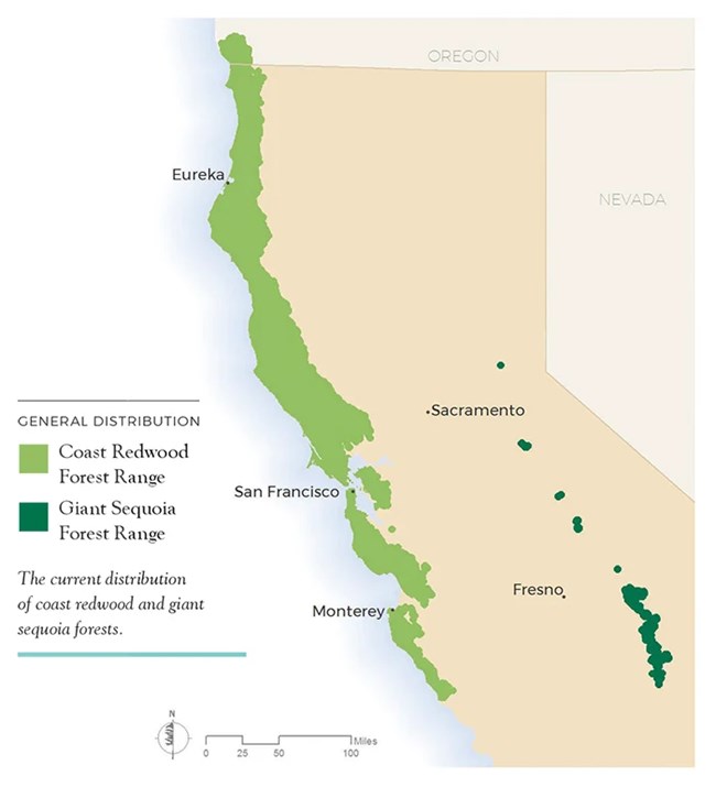
The Franciscan Formation provides ideal soil for the Coastal Redwoods. The redwoods are found only in places where the rocks are of Franciscan age. In Marin County, they’re restricted to the Muir Woods and Mount Tamalpais region. They are not found north where more recent sediment has covered the Franciscan rocks, or to the west of the San Andreas fault on the Point Reyes peninsula which is part of the oceanic plate. Redwood distribution, therefore, is intimately linked to the geologic history of the region.

John St. James
The Rocks of Muir Woods
Basalt
The igneous rocks of the area are basalt and were formed in underwater volcanoes on the ocean floor far out in the Pacific Ocean. Unlike the towering mountains we think of on land, these were little more than cracks in the ocean floor that spewed out lava slowly over the centuries to form the rocks we encounter today. Basalt is dark in color, and like all erupted lava, has tiny holes in it from gas bubbles in the lava. The basalt of the area is called pillow basalt because as it erupted into the seawater, it quickly cooled into pillow-shaped blobs a yard long.

Radiolarian Chert
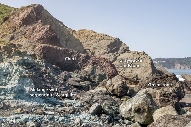
Plate tectonics moved these rocks closer to the North American continent until they collided. As the two plates collided, the oceanic plate was pushed under the continental plate because it is heavier and denser. Rocks scraped up onto the continental plate and began the formation of the Coast Ranges, where Muir Woods is located. Still under water, sediment began to build up on the igneous basalt. This was primarily composed of the skeletons of tiny animals called radiolaria. Radiolaria are single-celled plankton that have elaborate skeletons composed of silica (the same mineral as glass and quartz)The sedimentary buildup of radiolaria over many, many years hardened into a rock substance known as chert. Chert in Muir Woods is red-brown in color, but may vary depending on the mineral found with it. It was laid in thin strips no more than 2 or 3 inches thick, and separated by a thin strip of siltstone sediment blown across it from the continent known as shale. Chert can be seen in the road cuts on the drive into Muir Woods. It is the hardest substance in the area. The Coast Miwok, indigenous to the area known today as Marin, traditionally use it for spear heads and stone knives.

Serpentine
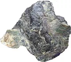
As the plates further collided, the rocks were pushed above the sea creating Mt Tamalpais as we know it today. The colossal pressures of this collision resulted in severely deformed landscapes. Local folding of the rocks resulted in mountain building forces, which further raised peaks above sea level. Because this folding was so tremendous and happened on a local scale there are no regularities in the peaks and valleys of the region. The warped and twisted formations exposed on the road cuts above Muir Woods show that they have been subjected to enormous pressures. Further erosion and weathering has exposed underground rock and resulted in valleys such as Muir Woods' Redwood Canyon.As the oceanic plate was pushed further under the continental plate, it hit the earth's mantle just under the crust. The force of this collision sent rock from the mantle up through cracks in the rocks above. The terrible forces these rocks were subjected to as they were forced to squeeze their way to the surface changed them to a new rock. One of the most common of these rocks is serpentine. Serpentine, a metamorphic rock, forms when peridotite, the material most of the earth's mantle is made of, reacts with water, usually beneath the earth's crust. California’s state rock, serpentine is a bright green, blue or gray in color. There are several outcrops of serpentine along the trails in Muir Woods.
Muir Woods Today
The rock cycle continues in Muir Woods. Geologic time makes it difficult to discern the current events, but the processes of rock building, erosion and change still take place. Over the millennia, these geologic forces will shape and change Muir Woods in unknown ways. One certainty is that, due to their longevity and Muir Woods' protected status, the redwoods will still be around to see the changes.For More Information
Geologic Activity - Golden Gate National Recreation Area (U.S. National Park Service) (nps.gov)
The Franciscan Formation: Where the Rock and Plate Tectonic Cycles Converge (berkeley.edu)
USGS: Geological Survey Bulletin 612 (Itinerary) (nps.gov)
Serpentinite FAQ - Golden Gate National Recreation Area (U.S. National Park Service) (nps.gov)
Chert FAQ - Golden Gate National Recreation Area (U.S. National Park Service) (nps.gov)
Basalt at Point Bonita (U.S. National Park Service) (nps.gov)
Franciscan Complex - Wikipedia Bedrock geology of the San Francisco Bay Area: A local sediment source for bay and coastal systems - ScienceDirect
Geologic Thrusts From The Past - Presidio of San Francisco (U.S. National Park Service) (nps.gov)
NPS Geodiversity Atlas—Muir Woods National Monument, California (U.S. National Park Service)
MtTamalpais_031011_web.pdf (savetheredwoods.org)
Geologic Thrusts From The Past - Presidio of San Francisco (U.S. National Park Service) (nps.gov)
