|
The stark beauty of a land shrouded in ice, bordering the ocean, and teeming with wildlife covers a plot taking place underneath it all. Beneath the splendor, larger forces are at work. The movement of tectonic plates and the delivery and formation of various rock types prescribe where birds nest, where Steller sea lions breed, and where glaciers flow. The varying rock of the fjords underwrites the spectacle seen above- in one place eroding into graceful arches, in another withstanding the ocean's constant blows. Crustal Collision Continental plates are pieces of crust visible as the continents of the Earth. Oceanic plates are heavier pieces of crust, sinking lower into the mantle and are covered by oceans. The collision of plates builds mountains at their edges, and the build-up and release of stress at the boundaries causes earthquakes. Mysteries of Movement In the park, as the North Pacific oceanic plate subducts beneath us, pressue builds up and pushes the edge of the continent upward. Since the 1990's, GPS measurements record this upward movement along the coast of the park at an average rate of 10mm/yr. When the pressure along the subduction boundary releases in the form of a large eaerthquake, the ground that was being pushed upward rapidly drops. For example, during the 1964 Great Alaska Earthquake, the coast of Kenai Fjords dropped between 3 and 8 feet. On a longer timescale, sea level has risen and drowned the coast of the park. In the heyday of the last Ice Age, which began about 25,000 years ago, ice built up in the curve of every peak, gouging out cirques; high valleys that nourished glaciers. A warming climate raised sea level 10,000 years ago and snow falling at lower elevations melted in the summers, no longer transforming to glacial ice. The cirques are now drowned in ocean water and the peaks that edged above Pleistocene ice are now islands surrounded by sea. Capes and Cliffs On the opposite side of the bay, the shore is eroded into spires, cliffs, and coves. Exposed areas reveal buckled layers of ancient sediment. Mud, transformed by heat and pressure, becomes shale, a fine-grained, dark-colored stone with many thin layers. With more time and more pressure, the shale becomes slate. If there is sand mixed with the original mud, it may become greywacke instead. These softer layers crumble into the sea more rapidly than basalt. Arches and spires form from the erosive action of waves. As you round the corner to the west, moving out of Resurrection Bay, Cape Aialik juts into the tumultuous water. The rock here is granodiorite, part of a massive pluton that extends down the shore, cropping up again at the entrance to Northwestern Fiord. Granodiorite is of a lighter color than the ocean sediment rocks. It is also more resistant to weathering, such as by the action of glaciers upon its surface. Where glaciers have carved the bedrock into impossibly steep cliffs, the slate crumbles once the ice melts away - but the granodiorite stands, its sheer surfaces draped with waterfalls. Cliffs and islands of greywacke, like Nuka Island, have virtually no seabirds nesting on them because their softer surface is too easily eroded to make a safe home. Granitic islands, on the other hand, are packed with birds. The Chiswell Islands, pinnacles of granodiorite stretching up from the sea floor, are home to tens of thousands of puffins, murres, and auklets. The affinity birds seem to have for granite is one of many ways that bedrock influences the life found on its surface. Sea lions, too, congregate on smooth granitic slabs washed by ocean swells to mate, give birth, and rest. 
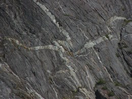
NPS / Paul Ollig Seams So Real As park glaciers retreat, more bedrock is exposed. Signs of past events are visible in the white seams of quartz shooting through the dark greywacke and in layers of upended slate which give silent testimony to the slow, inexorable compression of plates. Ice has left its scouring marks across every surface. Once the ice is gone, these signs of the past are quickly engulfed by a verdant wave of life which flows across the landscape, rushing forth to fill every conceivable niche and to hide the larger forces at work.
The Kenai Fjords National Park Geologic Resources Inventory has more information about the geologic formations here in Kenai Fjords National Park
|
Last updated: September 6, 2020
