Last updated: August 29, 2024
Article
2021 Horne Fire on Isle Royale

Abigail Winters
Fire on Isle Royale
The summer of 2021 was warm and dry across the northern Midwest. Temperatures were above average, and rainfall was dramatically below normal, leading to a drought. This weather contributed to the spread of several wildfires across the Lake Superior region.
Despite its isolation, Isle Royale is not immune to elevated fire conditions. On August 10, 2021, lightning struck the island several times during a major storm event. These lightning strikes resulted in multipe small fires on the island's northeastern end.

Mike Ausema
Island Ablaze
The most signifact of these fires ignited near the Duncan Bay/Tobin Harbor Portage Trail. Initially, this small fire burned with a low flame and spread slowly. But on August 22, 2021, the fire expanded significantly when strong west winds pushed it up and over the Greenstone Ridge. Following the blowup, the fire officially became known as the Horne Fire.
The Horne Fire would go on to burn approximately 335 acres, becoming the third largest wildfire in recorded Isle Royale history, and the most significant wildfire since 1948.

Abigail Winters
Suppression Efforts
Wildland firefighters from four different agencies across five states assisted in fire suppression efforts. Aircraft was used to monitor the size and spread of the fire. A single-engine air tanker (SEAT) delivered suppressant by scooping water from Lake Superior and strategically dropping it over the fire. Other tactics included creating firelines, backfiring, monitoring, and creating defensible space around structures.

Kassandra Klein
Containment
Eventually, rainfall increased. Although fire activity diminished, the fire continued to smolder in some places within thick duff layers. Isle Royale closed for the season on October 31, 2021, and the fire was inspected a final time before being left to extinguish in the winter elements. In the spring, staff assessed the burn area. The fire was declared contained on June 6, 2022, and officially out on June 10, 2022.

NPS
Lasting Impact
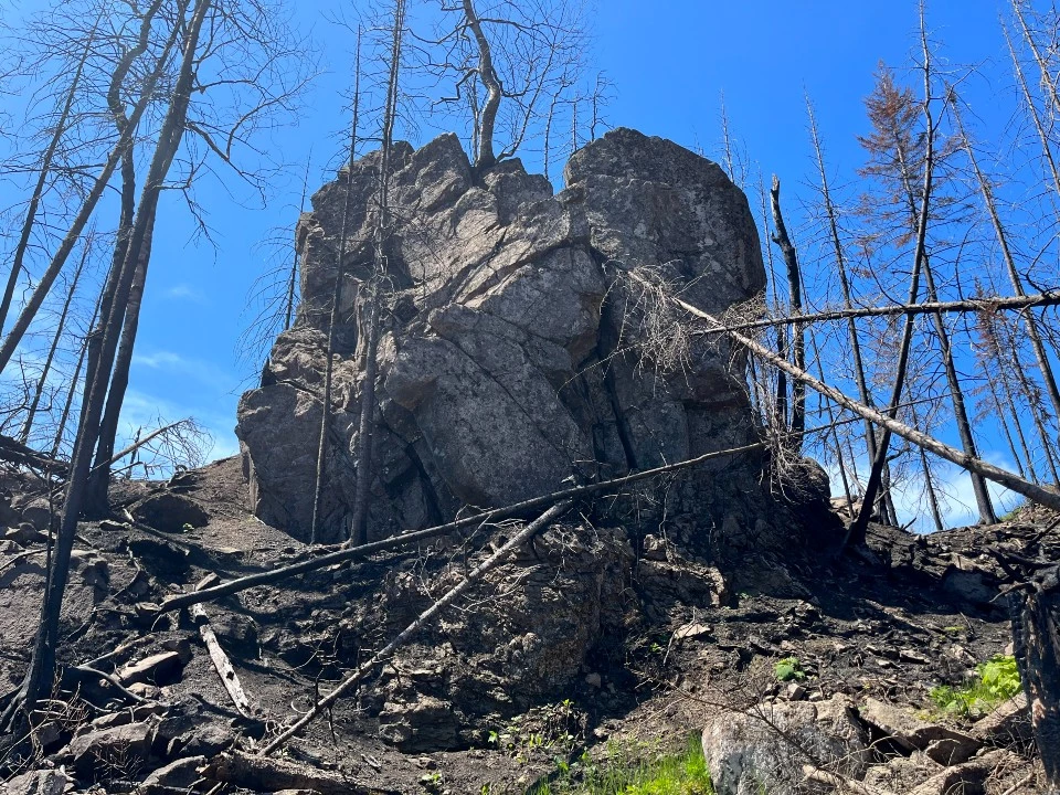
In its wake, the Horne Fire left only remains of what used to be a dense boreal forest. Monument Rock, previously shrouded by dense vegetation, has reclaimed its position as an icon of the ridge and is now visible from Hidden Lake. Prior to the fire, moss-covered boulders and lichen extending from spruce and fir branches lined the trail to Lookout Louise. Now the trail is marked by burned snags, naked boulders, and a charred understory.
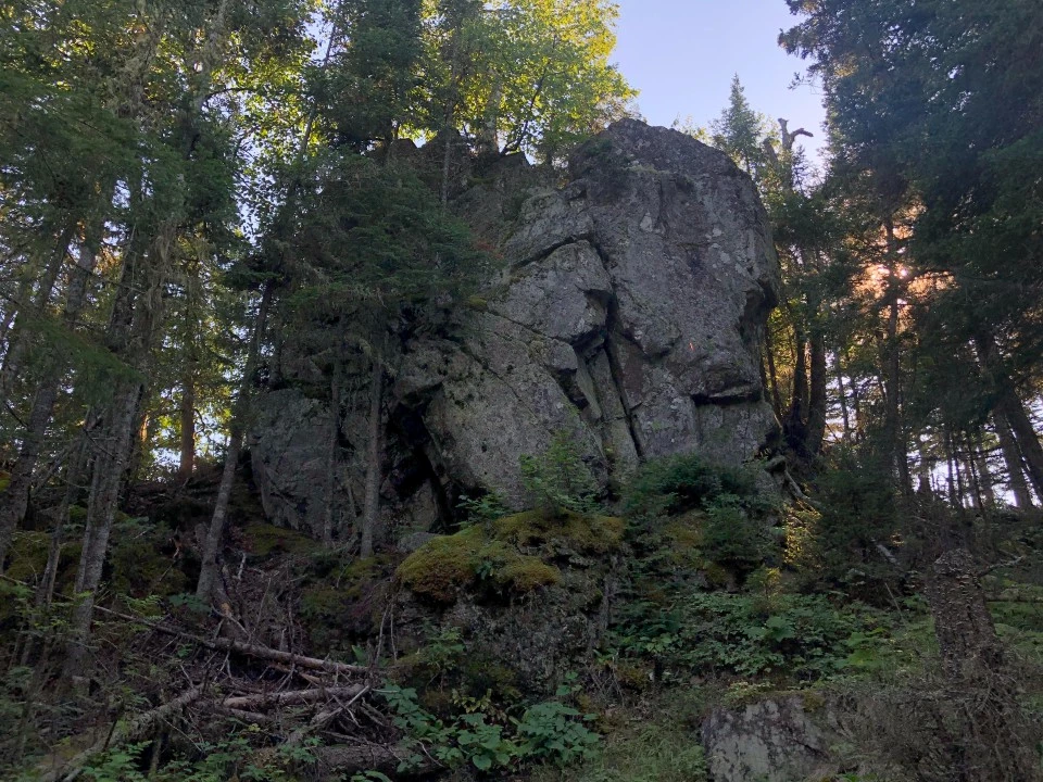
Left image
Large boulder near Lookout Louise in 2020, pre-fire.
Credit: Bridget Byrne
Right image
Large boulder near Lookout Louise in 2022, post-fire.
Credit: Bridget Byrne

Valerie Martin
Research
The area may look different, but wildfire is an agent of necessary change. Fire's role in an ecosystem is known as fire ecology. At the site of the Horne Fire, Isle Royale ecologists now have a living laboratory, and these researchers can begin to study the relationships between fire, living things, and an island environment.
In 2022, researchers began monitoring the freshly scarred landscape for invasive species, and surveyed for new moose exclosures to be constructed in order to study the impact of moose browse in a burn area.
Timeline
General fire ban goes into effect on Isle Royale due to ongoing drought conditions and elevated fire danger. All areas of the park are closed to the lighting and maintaining of wood or charcoal fires.
There are several lightning strikes on Isle Royale in a major storm event. One of the strikes ignites a small fire near the Duncan Bay/Tobin Harbor Portage Trail. A small, separate lightning-caused fire ignites on West Caribou Island, going undetected until August 27th.
A Type 3 incident commander from the National Park Service Midwest Regional Office arrives at Isle Royale and assumes command of the fire near the Duncan Bay portage trail.
The Horne Fire is mapped at 0.3 acres. Fire activity is minimal, smoldering is exhibited.
Strong westerly gale force winds push the Horne Fire up and over the Greenstone Ridge, greatly expanding fire size and spread. A fire ignites on Minong Island, located in northeastern Tobin Harbor near Scoville Point, from a suspected spot fire.
Isle Royale Superintendent issues closure orders affecting eastern Isle Royale trails, campgrounds and docks, closing Duncan Narrows Campground, Duncan Bay/Tobin Harbor Portage Trail, Tobin Harbor Dock (with the exception of seaplane dock for concession seaplane operation as conditions allow), Hidden Lake Dock, Hidden Lake Trail and Lookout Louise, Greenstone Ridge Trail east of the Duncan Bay/Tobin Harbor Portage Trail junction, Stoll Trail and Scoville Point.
Fire crews from four different agencies begin arriving on Isle Royale to assist with fire management.
Single engine airtankers begin conducting water-drops on hot spots.
Closures expand to include Lane Cove Trail and campground, Greenstone Ridge Trail east of Mount Franklin junction, Mount Franklin trail between the Greenstone Ridge Trail and Tobin Harbor Trail, Merritt Lane Campground and dock, and cross-country zones 8, 9, 10, 11, 34, 35, 36.
The Horne Fire is mapped at 200 acres and is 15 percent contained. Fire activity is minimal.
Fire crews conduct mop up operations and patrol structures.
Air support is coordinated through the National Wildfire Coordinating Group and Minnesota Department of Natural Resources to provide reconnaissance and monitoring from the air. Fixed wing aircraft are being used as needed to provide additional confirmation of fire size and spread.
The Horne Fire is mapped at 245 acres and is 15 percent contained.
A fire on West Caribou Island, an island in Rock Harbor near Middle Islands Passage, is detected. The fire is out and determined to be a single tree torching event, burning .10 acres.
A fire on West Caribou Island, an island in Rock Harbor near Middle Islands Passage, is detected. The fire is out and determined to be a single tree torching event, burning .10 acres.
The Horne Fire is 20 percent contained.
Fire crews conduct operations to create defensible space around Kemmer Cabin, a cabin near Hidden Lake, and Rock Harbor developed area. It is determined that no structures have sustained fire damage, except a Minong Island outhouse on August 21.
It is determined that the fire on Minong Island ignited from a lightning strike, not a spot fire.
Fire activity is minimal due to overnight rainfall amounting .5 to .7 inches.
Prep work on Duncan Bay/Tobin Harbor Portage Trail and Greenstone Ridge Trail is 90 percent complete. Hose is laid and sprinklers are utilized to defend Kemmer Cabin. Structure protection preparation at Tobin Harbor structures begins.
The Horne Fire is mapped at 245 acres and is 20 percent contained. Relative humidity is high, resulting in low fire activity.
Prep work on Tobin-Duncan portage trail and Greenstone Ridge Trail is completed. Kemmer Cabin, Minong Island, and Gale Island are monitored for further fire activity.
The Horne Fire is mapped at 370 acres and is 35 percent contained. Fire activity is low.
Fire crews begin to depart the island.
Closures at Lane Cove Trail and campground, Mount Franklin Trail, Duncan Bay Campground and dock, Stoll Trail and Scoville Point are lifted.
Fire crews conduct maintenance burns around Mott Island and Rock Harbor.
Mop-up is completed and equipment is removed from Duncan Narrows Campground and Kemmer Cabin areas.
Isle Royale National Park closes for winter season, remaining staff members depart the island.
The Horne Fire is inspected a final time. Fire continues to smolder in some places, in thick duff layers.
Final mapping, reflecting the most accurate measurements, shows 335 acres burned.
Staff visits the site of the Horne Fire to monitor and assess damage. No visible smoke is recorded. There is a tremendous amount of dead and down trees.
Due to lack of snow cover and unseasonably warm weather in the island's interior, the fire is not yet officially declared out.
A fire crew arrives on Isle Royale to assist with clearing hazard trees from the burn area.
The Horne Fire is declared 100 percent contained.
The Horne Fire is officially declared out.

Matt Kania
Wildfire Through A Creative Lens
Over the course of three years, artist Matt Kania investigated the Horne Fire burn area through the lens of creativity. The result of Kania's exploration was After the Burn: Beauty and Renewal on Isle Royale – 24 plein air and 7 studio oil paintings and drawings documenting the visual scars of the Horne Fire and the subsequent process of vegetative renewal.Check out the After the Burn: Beauty and Renewal on Isle Royale digital exhibit.
Reflections on a Burn
Loading results...
Tags:
fire
,
wildland fire
,
isle royale
,
greenstone 2022
,
succession
,
the greenstone
,
wildfire
,
horne fire