An official website of the United States government
Here's how you know
Official websites use .gov A
.gov website belongs to an official government
organization in the United States.
Secure .gov websites use HTTPS A
lock (
) or https:// means you've safely connected to
the .gov website. Share sensitive information only on official,
secure websites.
The new park map shows the changes that occurred to Halema‘uma‘u and Kīlauea caldera in 2018.
NPS Map
On the Road to Recovery
In 2018, a new eruption of Kīlauea volcano changed the island of Hawai‘i forever. From May through August, large lava flows covered land southeast of the park destroying over 700 homes and devastating residential areas in the Puna District. At the same time, the summit area of the park was dramatically changed by tens of thousands of earthquakes, towering ash plumes, and a massive collapse of Kīlauea caldera.
Although the eruption has ended, the park faces a challenging road to recovery. Damage to park infrastructure was severe and included wrecked buildings, massive rock falls, collapsed and cracked roads and trails, and numerous breaks to water and sewer lines. Recovery began in August, 2018 with assessment and stabilization of park infrastructure, restoration of utilities, and mitigation of safety issues. Most of Hawai‘i Volcanoes National Park is now open and welcoming thousands of visitors each day as the recovery process continues.
Rebuilding and Reopening a Park
Areas reopened:
Uēkahuna bluff (Jaggar Museum parking lot and viewing areas)
Chain of Craters Road
Volcano House
Crater Rim Drive to Kīlauea Overlook
Halema‘uma‘u Trail via Crater Rim Trail by Volcano House
Devastation Trail
A 1.1-mile section of Byron Ledge Trail that connects Devastation Trail to Kīlauea Iki Trail
Steam Vents
Sulphur Banks
Kīlauea Iki Trail
Nāhuku (Thurston Lava Tube)
Pu‘upua‘i Overlook
Kīlauea Military Camp
Crater Rim Trail from Kīlauea Overlook to Kīlauea Iki Overlook
Ka‘ū Desert Trail to Hilina Pali (the six-mile section west of Jaggar Museum remains closed)
Kīpukapuaulu
Tree Molds off Mauna Loa Road
Hilina Pali Road is open to Kulanaokuaiki Campground to vehicle traffic, and to pedestrians and cyclists beyond
Mauna Loa Summit (may temporarily close on occasion due to severe weather conditions)
Kahuku Unit
Nāpau Trail beyond the campground to the base of Puʻuʻōʻō (Puʻuʻōʻō remains closed due to instability)
Byron Ledge Trail from Halema‘uma‘u Trail to Kīlauea Iki Trail
Areas undergoing evaluation:
Ka‘ū Desert Trail from Mauna Iki Trail to Crater Rim Trail
Crater Rim Drive and Trail from southwest of Jaggar Museum (Uēkahuna) to Keanakāko‘i Crater
A new loop between Crater Rim Drive and Crater Rim Trail near Keanakāko‘i.
Byron Ledge Trail along the edge of the caldera floor
Areas closed indefinitely:
‘Iliahi Trail
Halema‘uma‘u Trail across caldera floor
Crater Rim Drive beyond Uēkahuna
Jaggar Museum
Recovery Chronology
June 9, 2021: Uēkahuna bluff reopens including the parking lot, restrooms, and viewing areas around the former Jaggar Museum which remains closed.
November 6, 2020: Park unveils new wayfinding wayside exhibits that include the transformed topography and several wayside exhibits discussing the 2018 eruption
October 17, 2020: Crater Rim Trail along Waldron Ledge (Kūpinaʻi Pali) reopens
August 19-22, 2019: a National Park Service geomorphology team visited areas of the park damaged by last yearʻs seismic events. The team found that some trails and areas identified as unstable a year ago continue to have safety concerns while other areas and trails have been reopened or will be repaired.
July 23-26, 2019: Engineers and representatives from the Central Federal Lands Highway Division of the Federal Highways Administration, Hawai‘i Department of Transportation, and park leaders completed a Road Safety Audit (RSA) of the park. The RSA is a formal safety performance examination of an existing park transportation infrastructure by an experienced, independent, multi-disciplinary audit team. The primary focus of an RSA is to quantitatively estimate and report on potential road safety issues and identify opportunities for improvements in safety for all road users. The RSA will help inform recovery projects.
July 11, 2019: Nāpau Trail from the campground to the base of Puʻuʻōʻō reopened.
July 9-10, 2019: A team of National Park Service planners and park managers conducted a site review to identify potential options for disaster recovery funding.
June 6, 2019: President Donald Trump signed a $19.1 billion disaster aid bill. Included in the bill is $78 million for the National Park Service to recover from hurricanes, wildfires, earthquakes, volcanic eruptions and other natural disasters that damaged national park sites in 2018.
June 4, 2019: The park reviewed a draft report on safety conditions of Nāhuku (Thurston Lava Tube) and is preparing to implement the recommendations to mitigate safety concerns and install monitoring equipment. While working to ensure that Nāhuku can be accessed safely, the park is also working on addressing parking congestion and related safety issues at the popular site, which were a concern prior to the 2018 eruptive events.
May 30, 2019: U.S. Secreatary of the Interior David Bernhardt visited the park and toured the damaged Jaggar Museum and Hawaiian Volcano Observatory. Secretary Bernhardt expressed support for park recovery efforts stating, "I wouldn’t be here if I didn’t think this was going to be a priority.”
May 17, 2019: The Federal Highways Administration has created a project web page for the work to repair park roads damaged in 2018.
May 9, 2019: 120 community members attend the “Road to Recovery” After Dark in the Park presentation where park leaders share recovery accomplishments and updates.
April 19, 2019: Most of Kīlauea Iki Trail reopened following extensive repairs to the earthquake-damaged trail. Park at Kīlauea Iki Overlook, and hike Crater Rim Trail towards the closed lava tube parking lot to pick up the trail. Hike in and hike out the same way, a 2.4-mile one-way trek. The section of trail leading to and on Byrons Ledge is badly damaged and remains closed.
March 29, 2019: The park interdisciplinary team conducted a field survey for potential new trails.
February 26, 2019: The park interdisciplinary team conducted a field survey for potential new trails.
February 19, 2019: Hawai‘i Volcanoes National Park reopens two trails and Mauna Loa Road - news release.
November 23, 2018: Crater Rim Drive between Keanakāko‘i Crater and Halema‘uma‘u reopens; park extends the open area of road several hundred feet to the second large earthquake fracture. This section of Crater Rim Drive remains open to pedestrians and bicyclists only and is not open to vehicle use.
November 23, 2018: Crater Rim Trail, from the trailhead at Chain of Craters Road, to the south rim of Keanakāko‘i Crater (approximately one mile), re-opens to the public.
November 23, 2018: The Ka‘ū Desert Trail from Highway 11 to Mauna Iki Trail, to the Mauna Iki Trailhead near Kulanaokuaiki Campground (8.8 miles of trail), reopens. Due to large amounts of volcanic ash, everyone is strongly advised to bring protective eye wear and an N95 dust mask if attempting this hike. People with respiratory illness and young children should avoid this trail when ash is present.
October 26, 2018: The Volcano House breakfast, lunch and dinner service resumes at The Rim, and Uncle George’s Lounge resumed its bar menu service - news release.
October 19, 2018: Coastal backcountry reopened - news release.
Hilina Pali Road is open to vehicle traffic to Kulanaokuaiki campground and is open to foot traffic beyond to the overlook. Most of the park is now open!
October 8, 2018: Mauna Loa Road and Mauna Loa backcountry reopen.
October 5, 2018: Mauna Loa Road and Mauna Loa i are scheduled to reopen Monday, October 8, 2018 (Discoverer's Day).
September 22, 2018: the park partially reopens - news release.
September 21, 2018: the park water system was inspected and certified to be potable (safe to drink) by Hawaiʻi state authorities.
September 20, 2018: the park interdisciplinary team met with facility experts and a structural engineer to review initial assessments of park buildings damaged by earthquakes. Several assessment teams will submit detailed reports in the coming weeks to help park managers plan for long term recovery.
September 18, 2018: 149 out of 184 park buildings and structures have been inspected for earthquake damage. 26 out of the 42 wastewater systems in the park have also been inspected.
September 17: Park managers met to review final plans for the park reopening on Saturday September 22.
September 13-14,2018: Orientation briefings were held with permitted commercial tour guides at Kīlauea Visitor Center to review new park conditions, limited parking challenges, and what areas and facilities will open. Inspectors with the Emergency Relief of Federal Roads and Trails of the Federal Highways Administration presented their findings after assessing the park.
September 12, 2018: Eight out of 43 building septic systems are determined safe for use. As news release listed critical safety concerns for visitors.
September 11, 2018: a Federal Highways Administration team began assessing earthquake damage on park roads and making emergency repairs.
September 10, 2018: Inspections of sewage lines at Kīlauea Visitor Center were completed finding no damage and the most critical public restrooms in the park are now determined to be safe for use.
September 5, 2018: The park announces a partnership with Mainstreet Pāhoa Association to loan exhibit features from Jaggar Museum to a visitor center site in downtown Pāhoa.
September 4, 2018: Assessments continue and the park interdisciplinary team meets for reopening planning.
August 30, 2018: A community "Talk Story" event about the future of Hawai‘i Volcanoes National Park was held at 10 a.m. at the Kahuku Unit.
August 29, 2018: 32 park buildings have been inspected for earthquake damage. The geomorphology team completed an initial interior inspection of Thurston Lava Tube. Further assessments with LIDAR scanning are needed to determine if the lava tube is safe to reopen.
August 28, 2018: Non-potable water has been restored to nine park buildings including the visitor center. 17 park buildings have been inspected for earthquake damage. Water has not yet been restored to the Volcano House and the entire park water system remains unsafe to drink.
August 27, 2018: Assessments continue as a park backcountry team met to review initial findings and prepare reopening plans.
August 24, 2018: The geomorphology team resumed park assessments.
August 23, 2018: Hurricane Lane impacts the island becoming the wettest storm in state history with rainfall accumulations of over 52.02 inches measured near the park.
August 22, 2018: a National Park Service geomorphology team began evaluating seismic stability of areas damaged or potentially weakened by earthquakes. Results help determine what areas are safe for visitors. Later that afternoon, the park temporarily paused all recovery efforts in preparation for Hurricane Lane.
August 21, 2018: Superintendent Cindy Orlando announces the park has set a goal of reopening some closed areas by September 22 – National Public Lands Day.
August 2, 2018: Summit collapse events and heightened earthquake activity end.
May 16, 2018: Onset of summit explosions and ash plumes.
May 11, 2018: Most of the park closes.
May 10, 2018: Halema‘uma‘u lava lake drains. USGS scientists anticipate explosive events at the summit to begin in a few days.
May 7: The park reopens.
May 4-6, 2018: The park is closed to assess damage from the earthquake on May 4.
May 4, 2018: A magnitude 6.9 earthquake, the biggest since 1975, shakes the island.
April 30, 2018: Pu‘u ‘Ō‘ō collapses.
Do you have a question about the recovery progress? Please send us your questions: e-mail us
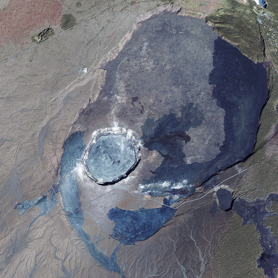
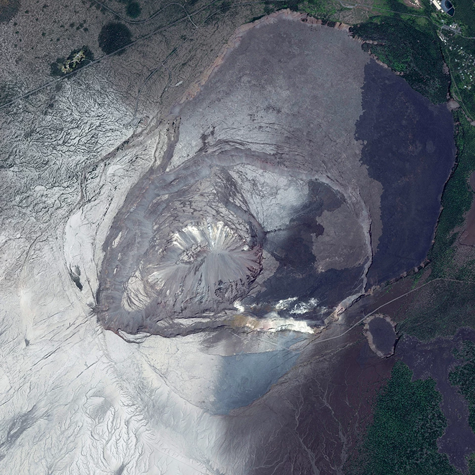
Kīlauea Summit - Before & After
Left image
NASA image taken on January 14, 2003
Right image
USGS photo taken on August 7, 2018
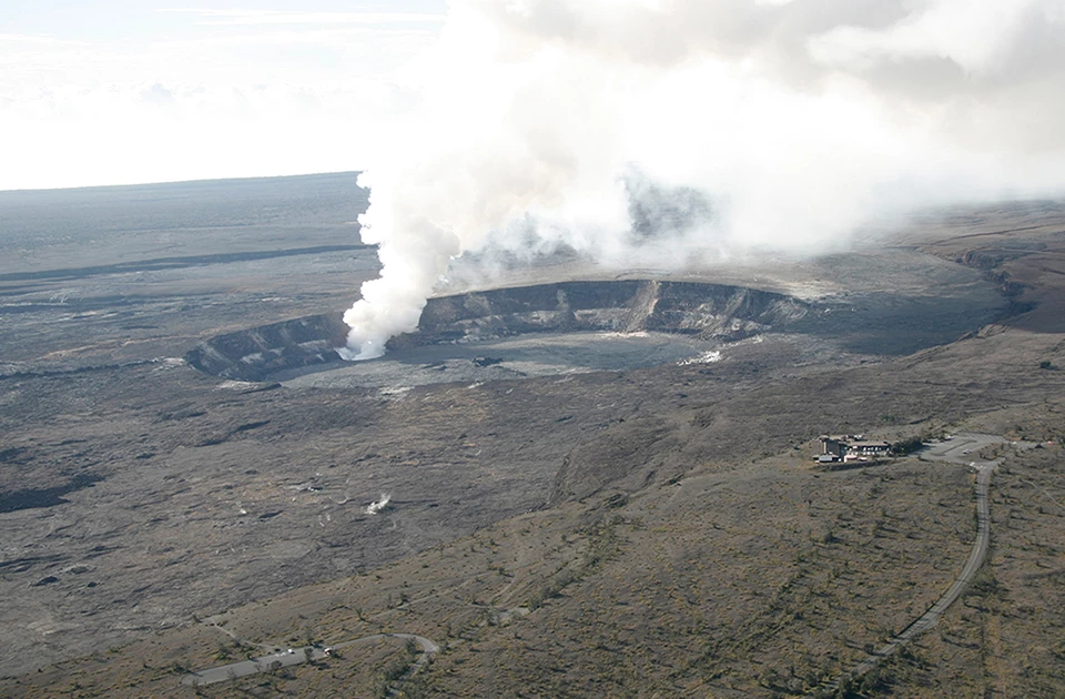
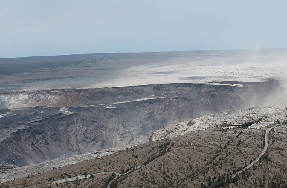
Kīlauea Summit - Then and Now
Left image
Kīlauea summit on November 28, 2008
Credit: Photo courtesy USGS - Hawaiian Volcano Observatory
Right image
Kīlauea summit on August 1, 2018
Credit: Photo courtesy USGS - Hawaiian Volcano Observatory
USGS - Hawaiian Volcano Observatory: Then and now. It has proven difficult to exactly match past and present views of Kīlauea's summit to show the dramatic changes in the volcanic landscape, but here's our latest attempt. At left is a photo taken on November 28, 2008, with a distinct gas plume rising from the vent that had opened within Halema‘uma‘u about eight months earlier. At right is a photo taken on August 1, 2018, to approximate the 2008 view for comparison.