
|
Lobby > Exhibits > Scientific Research > Research in The Deep Research in the DeepCHARTING YELLOWSTONE LAKE A final frontier lies within the cold waters of Yellowstone Lake. The earliest known attempt to measure the lake and map its shoreline occurred during the Hayden Expedition of 1871. Hayden’s group worked under the most primitive conditions. They used a small wooden boat with a woolen blanket for a sail. 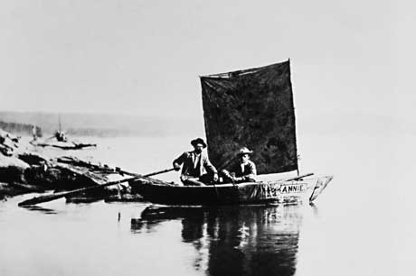 Mapping took 24 days. Hayden's group used a knotted rope tied with lead sinks to determine the depth of the lake and took approximately 300 soundings. They estimated the lakes shoreline was 130 miles (209 km). They also located the deepest part of the lake, calculating it to be somewhat less than 500 feet (152 m) deep. Modern surveys place the lakes shoreline at 141 miles (227 km), while its greatest depth is 430 feet (131 km).
You need to upgrade your Flash Player
Next | 1 > 2 > 3 > 4 | Next Section: Spires of the Deep |
|
||||||||||||||||||||||||||||||