Nenana River Trails Environmental Assessment


Denali National Park is considering developing approximately 17 miles of trails in the area of the park between the Nenana River and the Parks Highway (the ‘Nenana River corridor’ - see map below). This project is intended to encourage many visitors to interact with the landscape of the park in a way that does not depend on access to the Park Road and does not impact wilderness.

These ideas are described and analyzed in an Environmental Assessment which is summarized below and can be read in full on the Planning, Environment, and Public Comment (PEPC) page for the Nenana River Trails project.

Please review the information below and provide your thoughts via the PEPC page for this effort during March 1 – 30, 2023.

Two informational meetings were held on March 9 and 10. Watch a recording of the virtual meeting.

Background

 
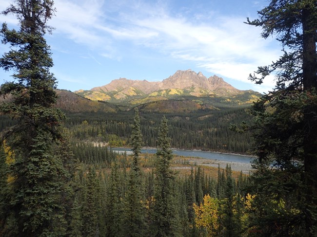
A landscape looking down a forested hill onto a river. On the far side of the river, forested slopes rise up to a tall, rocky mountain. The green hillsides of spruce trees are mixed with yellow and orange fall colors from deciduous trees.
Looking east from the corridor across the Nenana River

NPS Photo

The Nenana River corridor extends from the Park Road entrance south to milepost 231 on the Parks Highway and is bounded to the west by the Parks Highway and to the east by the Nenana River.

This area is primarily a mixed white spruce broadleaf forest, a taiga forest community comprised largely of white spruce and aspen along with black spruce, willows, Labrador tea, blueberry, low bush cranberry, and sphagnum moss. It provides habitat for many avian species, small mammals, and larger mammals such as moose and bears.

This non-wilderness area is currently undeveloped, but has been considered for trail construction since at least the 1997 Frontcountry Development Concept Plan, which also proposed the development of a campground in this area. These ideas were later incorporated into the 2006 Backcountry Management Plan.

More recently, the Nenana River corridor was chosen as part of the route for the proposed Alaska LNG pipeline which would be mostly buried through the area. A wayside and trailhead was constructed at the southern end of this area at Parks Highway milepost 231 in 2022. The Alaska Department of Transportation-led Parks Highway Planning and Environmental Linkages Study considers transportation improvements along the Parks Highway through the Nenana River corridor, including ideas for non-motorized and pedestrian access.

Trails developed in this area have the potential to:

  • Provide easily-accessible and low-cost recreational opportunities for visitors and local residents
  • Provide on-trail opportunities for multiple uses, varying skill levels, and diverse user groups
  • Connect local communities and commercial enterprises to the park with non-motorized routes
 
A map of a small area in the northeast corner of Denali national park and preserve. The map covers from the park entrance and Riley Creek day use area south to where the Parks Highway crosses the Nenana River approximately 6 miles south of the park entran
Map of the proposed 17 miles of trail in Denali National Park

NPS Image

 
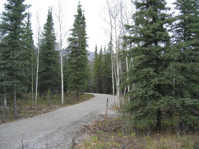
A gravel path that is flat and smooth makes a wide turn through the forest. The path is over six feet wide.
Example of a multiuse trail

NPS Photo

The Proposed Action

The Proposed Action would create a total of approximately 17 miles of trail in the Nenana River corridor.

Of this total, approximately eight miles would be a Class IV multiuse trail designed for safe concurrent use by bicyclists and pedestrians. The multiuse trail would be approximately eight feet wide and would have a primarily crushed gravel surface. Trail location and design would create adequate sightlines, grades, and curves to reduce wildlife and user conflicts as well as encourage moderate cycling speeds.

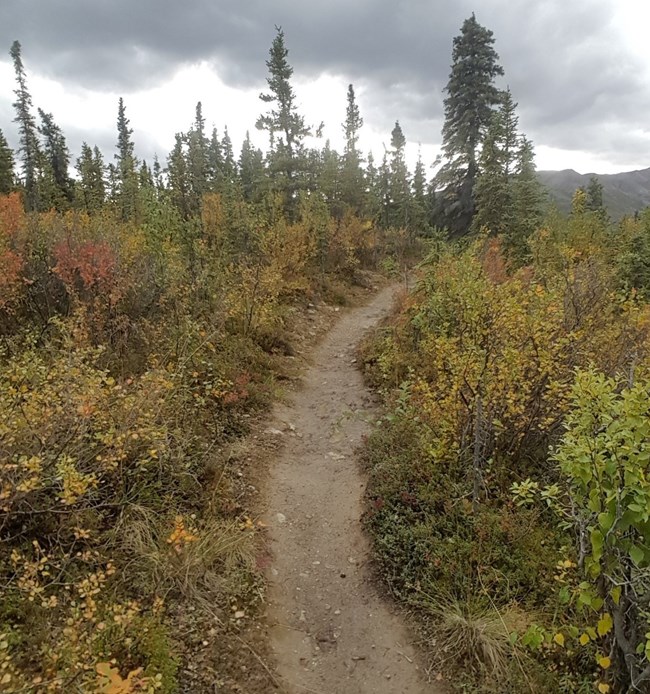
An additional approximately nine miles of trail in the project area would be open to pedestrians only. The majority of these hiking trails would be Class II, approximately one to two feet wide with a primarily natural surface.

The southernmost mile of the hiking trails would form a universally accessible loop from the trailhead at mile 231 of the Parks Highway in conjunction with the southernmost mile of the multiuse trail. This mile of accessible pedestrians-only trail would be approximately 5 feet wide and would have a crushed gravel surface.

 
A dirt path cuts through a brushy landscape. The path is narrow, only one to two feet wide and small rocks are visible embedded in the trail surface.
Example of a hiking trail

NPS Photo

In addition to wayfinding signage on the trails, there may be other facilities constructed along the trails, including benches, interpretive signs, or overlook areas. These additional facilities would be concentrated near trailheads.

An approximately eight-foot-wide bridge allowing for safe concurrent use by pedestrians and cyclists would cross Riley Creek and connect the trail system to the Riley Creek day use area on the northern end of the project area. The bridge could be constructed as a single span of 250’ or as two 125’ segments. One 125’ span would be sufficient to cross the stream channel, while a second 125’ span would improve accessibility and keep the trail out of the floodplain on the north side of Riley Creek.

No other facilities would be constructed on or near the trails under the proposed action.

All trails would be open for their respective uses year-round. Although the 2020 Winter and Shoulder Season Visitor Services EA authorized motorized grooming of trails in this area, the NPS does not intend to formalize any winter recreational activities or trails in the project area as of 2023.

Commercial use would be allowed on the trails under existing laws, NPS policies, and park planning documents. Any novel commercial uses that might be proposed in the future would be evaluated by standard park compliance and commercial services processes.


Alternatives to the Proposed Action

In addition to the Proposed Action described above, the NPS has explored a few other options for recreational development in the Nenana River corridor.

No Action

The NPS could take no action in the area, not developing any trails or other infrastructure.

Wait for the Railroad Realignment

This alternative (Alternative 3) would look like the Proposed Action described above, but the multiuse trail would only be constructed if the railroad were realigned out of the area to the west side of the highway. If the railroad is never realigned, no multiuse trail would be built by the NPS.

Trails and Campgrounds

This alternative (Alternative 4) would look like the Proposed Action, but would add two small walk-in campground to the network of trails. One campground would be located just to the east of the former gravel pit near mile 234 of the Parks Highway and one campground would be located in the vicinity of the confluence of the Nenana River and the Yanert Fork of the Nenana.

Both campgrounds would be rustic and provide three to seven tent pads each. Additional facilities associated with the campgrounds would include cooking shelters with or without picnic tables, wildlife safe food storage lockers, water catchment systems as needed, and pit or composting toilets. Campgrounds would potentially require reservations and/or user fees and would not be available for use during winter months. The intent of the campgrounds would be to provide a visitor experience that is distinct from camping in a drive-up campground and from the trailless backpacking otherwise offered in Denali.

All other aspects of Alternative 4 would be the same as described in the Proposed Action.

 
Two maps of the proposed area side by side. On the left, alternative 3 shows that the hiking trail and multi-use trail are contingent on railroad realignment. On right, both trails are built and two campgrounds exist along the hiking trail.
Left: In Alternative 3, the multiuse trail is only constructed if the railroad is realigned to the west side of the highway. Right: In Alternative 4, two small campgrounds would be constructed along with the 17 miles of trail described in the Proposed Action.

NPS Images

Summary of Alternatives

Action Alternative 1: No Action Alternative 2: Construct Multiuse and Pedestrian Trails (Preferred Alternative) Alternative 3: Wait for the Railroad Realignment Alternative 4: Trails and Campgrounds
Multiuse Trail None 8 miles None if the railroad is not realigned to the west of the Parks Highway. If the railroad is realigned, 8 miles of multiuse trail would be constructed, including 2 miles on the former railroad alignment. 8 miles
Hiking Trail None 9 miles 10 miles 9 miles
ABA Accessible Trail None 2 miles Before realignment: 1 mile
After realignment: 2 miles
2.5 miles
Overlooks, Benches, and Interpretive Signs None Possible, concentrated near trailheads Possible, concentrated near trailheads Possible, concentrated near trailheads and campgrounds
Bridge Over Riley Creek None Multiuse bridge connecting to Riley Creek Day Use Area Multiuse bridge connecting to Riley Creek Day Use Area Multiuse bridge connecting to Riley Creek Day Use Area
Winter Use No change, area available for off-trail day use Trails available for day use, no grooming at present Trails available for day use, no grooming at present Trails available for day use, no grooming at present
Commercial Use Managed according to existing guidance Managed according to existing guidance Managed according to existing guidance Managed according to existing guidance
Campgrounds None None None Two walk-in campgrounds with 3-7 tent spaces each and associated facilities including cook shelters, food storage, and pit or composting toilets
 

Environmental Consequences

If the NPS took action on any of the alternatives described above there would be consequences for the environment. Some of the key issues of concern include:

Wildlife

  • Human-wildlife interactions: Increasing the number of visitors on the landscape in the Nenana River corridor could increase the potential for human-wildlife interactions, leading to displacement of individual animals, the potential for unsafe wildlife encounters, and the potential for habituation and food conditioning.
  • Habitat and movement patterns: Development of trails in the Nenana River corridor could fragment available wildlife habitat and alter wildlife movement patterns.

Vegetation and Wetlands

  • Removal and disturbance: Trail development would remove approximately 11 acres of vegetation and would require the fill or disturbance of 0.6 acres of wetlands.
  • Composition change: Development of trails could lead to vegetation composition change, particularly immediately adjacent to trail corridors.
  • Invasive species: Construction and use of trails in the Nenana River corridor could introduce invasive species to the area.

Cultural Resources

  • Visitor disturbance: The development of trails and the introduction of visitor use in the Nenana River corridor could increase the potential for cultural resource disturbance.

Recreation Resources and Visitor Experience

  • Development in undeveloped area: Creating developed recreational opportunities in the Nenana River corridor would introduce infrastructure and visitor use to an area of the park that largely has neither, increasing the amount of bicycle and pedestrian activity in the area.
  • Miles of trail vs. trail-less area: Trail development would increase the miles of developed trails in the park available to visitors and would decrease the overall amount of trailless terrain in Denali.
  • Multimodal connectivity: Establishment of a multiuse trail would increase non-motorized connectivity between the park entrance area and nearby visitor accommodations and residential areas.
 

Summary of Environmental Impacts

The environmental impacts from each alternative area are summarized in the table below.

Issue Alternative 1: No Action Alternative 2: Construct Multiuse and Hiking Trails (Proposed Action and Preferred Alternative) Alternative 3: Wait for the Realignment Alternative 4: Campgrounds and Trails
Wildlife:
Human-wildlife interactions
No change to the potential for human-wildlife interactions. Increased potential for human-wildlife interactions from use of the trails. Before Realignment: Same as Proposed Action except no multiuse trail or bicycle use, less opportunity for surprise human-wildlife interactions.
After Realignment: Same as Proposed Action.
Same as Proposed Action with a greater likelihood of human-wildlife interactions due to concentrations of human food at the campgrounds and the possibility of wildlife becoming conditioned to receiving human food.
Wildlife:
Habitat and movement patterns
No change to wildlife movement patterns. Wildlife may be attracted to the trails as travel corridors or may avoid the trails due to human presence. Trails may fragment existing habitat or prevent wildlife access to habitat. Before Realignment: Same as Proposed Action but to a lesser degree due to no multiuse trail.
After Realignment: Same as Proposed Action.
Same as Proposed Action with greater impacts to wildlife movement due to the longer-term, more stationary visitor use of the campgrounds and the attraction or avoidance that wildlife may exhibit to that type of use.
Vegetation and Wetlands:
Removal and disturbance
No vegetation removal or wetlands disturbance. 11 acres of vegetation removal.
0.85 acres of wetlands crossed by trails.
0.6 acres of wetlands filled.
Before Realignment: 4 acres of vegetation removal. 0.17 acres of wetlands crossed by trails. 0.23 acres of wetlands disturbed.
After Realignment: Same as Proposed Action.
Same as Proposed Action, but with 6 additional acres of vegetation removal for establishment of campgrounds and an increased possibility for social trail development near campgrounds.
Vegetation and Wetlands:
Composition change
No direct influence on vegetation composition change. Vegetation composition change immediately adjacent to 17 miles of trail as the disturbed ground favors particular species. Before Realignment: Same as Proposed Action but along only 10 miles of trail.
After Realignment: Same as Proposed Action, less two miles of multiuse trail on the former railroad alignment.
Same as Proposed Action, with additional vegetation composition change within and around the campgrounds.
Vegetation and Wetlands:
Invasive species
No change in the probability of invasive species spread. Increased possibility for invasive species spread along 17 miles of trail. Before Realignment: Same as Proposed Action but only along 10 miles of trail.
After Realignment: Same as Proposed Action.
Same as Proposed Action, with additional possibility for invasive species spread in and around the campgrounds.
Cultural Resources: Visitor disturbance No change. Increased potential for cultural resource disturbance from use of the trails. Before Realignment: Same as Proposed Action but only along 10 miles of trail.
After Realignment: Same as Proposed Action.
Increased potential for cultural resource disturbance from use of the trails as well as two small campgrounds.
Recreation Resources and Visitor Experience:
Development in undeveloped area
No change to the level of development or visitor use in the area. Change in Nenana River corridor from a largely undeveloped area to a visitor destination supporting trails and visitor use of the trails. Before Realignment: Same as Proposed Action except no multiuse trail or bicycle use.
After Realignment: Same as Proposed Action.
Change in Nenana River corridor from a largely undeveloped area to a visitor destination supporting trails and campgrounds and visitor use of these facilities.
Recreation Resources and Visitor Experience:
Miles of trail vs. trail-less area
No additional construction of trails or loss of trail-less area in the park. 17 miles of trail added to the existing 40 miles across the park. Loss of approximately 2,850 acres of trail-less terrain of the 6 million acres in the park. Before Realignment: 10 miles of trail added to the existing 40 miles across the park.
After Realignment: Same as Proposed Action.
17 miles of trail added to the existing 40 miles across the park. Two small hike-in campgrounds provide a novel visitor experience. Loss of approximately 2,850 acres of trail-less terrain of the 6 million acres in the park.
Recreation Resources and Visitor Experience:
Multimodal connectivity
No increase in multimodal connectivity, pedestrians and cyclists continue to use Parks Highway shoulder. Multiuse trail for dedicated pedestrian and bicycle connection to the park entrance from trailhead at mile 231 of the Parks Highway. Before Realignment: No increase in multimodal connectivity, pedestrians and cyclists continue to use Parks Highway shoulder.
After Realignment: Same as Proposed Action.
Multiuse trail for dedicated pedestrian and bicycle connection to the park entrance from trailhead at mile 231 of the Parks Highway.
 

Mitigations

In addition to following best management practices in trail construction, the NPS would incorporate the following mitigations into any trail development in this area.

Wildlife

  • Trail construction and debris deposition avoided on the steep, sandy bluffs that provide important insect and pollinator habitat
  • Vegetation cut only during times of year least likely to impact migratory bird species, per guidelines established under the Migratory Bird Treaty Act
  • Trails routed to avoid food-dense areas (e.g., soapberry patches)
  • Trails established with adequate sightlines to reduce the possibility for human-wildlife encounters, especially with regard to bicycles on the multiuse trail

Vegetation and Wetlands

  • When possible, vegetation cut in the fall in preparation for the next year’s construction to avoid attracting spruce bark beetles
  • Trails routed to minimize the need for vegetation removal and wetlands impacts
  • Wetlands addressed with boardwalks rather than fill whenever possible
  • Tundra mats saved for revegetation of borrow pits and other disturbed areas whenever possible
  • When not hauled off-site for disposal, cut vegetation would be scattered to encourage decomposition and minimize impacts to vegetation that would be covered by piles of removed vegetation

Cultural Resources

  • Trails routed and infrastructure placed to avoid cultural resource sites
  • Archaeology monitor to be on site during project implementation
  • Any route changes or borrow pits would be surveyed for cultural resources prior to trail construction and any discovered cultural resources would be avoided
  • If cultural resources or items protected by the Native American Graves Protection and Repatriation Act were discovered during project implementation, all project-related activities in the vicinity of the discovery would be stopped and the park archaeologist would be notified immediately. The NPS in consultation with the State Historic Preservation Officer and other consulting parties would determine a course of action.

Visitor Use and Experience

  • When possible, mechanical equipment or helicopter use concentrated in low-visitation times of year
  • Helicopters routed away from wilderness areas or high-visitation areas
  • Equipment and construction activity staged away from visitor areas whenever possible

Soundscapes

  • When possible, mechanical equipment or helicopter use concentrated in low-visitation times of year
  • Helicopters routed away from wilderness areas or high-visitation areas
  • Motorized equipment will use noise-reducing backup alarms whenever possible
 
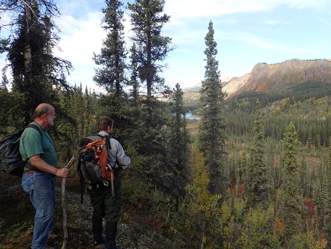
Two hikers stand at the top of a forested slope. The men look out across a wooded valley to a mountain and river in the distance.
Hikers enjoy a view from the Nenana River Trails area.

NPS Photo

Get Involved

Please tell the National Park Service what you think about these ideas!

The Environmental Assessment fully describing and analyzing the information summarized on this webpage can be read in full on the Planning, Environment, and Public Comment (PEPC) page for the Nenana River Trails project.

Please provide your thoughts via the PEPC page for this effort during March 1 – 30, 2023.

Two informational meetings were held on March 9 and 10. Watch a recording of the virtual meeting.

Thank you for providing feedback!

Last updated: March 16, 2023

Park footer

Contact Info

Mailing Address:

PO Box 9
Denali Park, AK 99755

Phone:

907 683-9532
A ranger is available 9 am to 4 pm daily (except on major holidays). If you reach the voicemail, please leave a message and we'll call you back as soon as we finish with the previous caller.

Contact Us