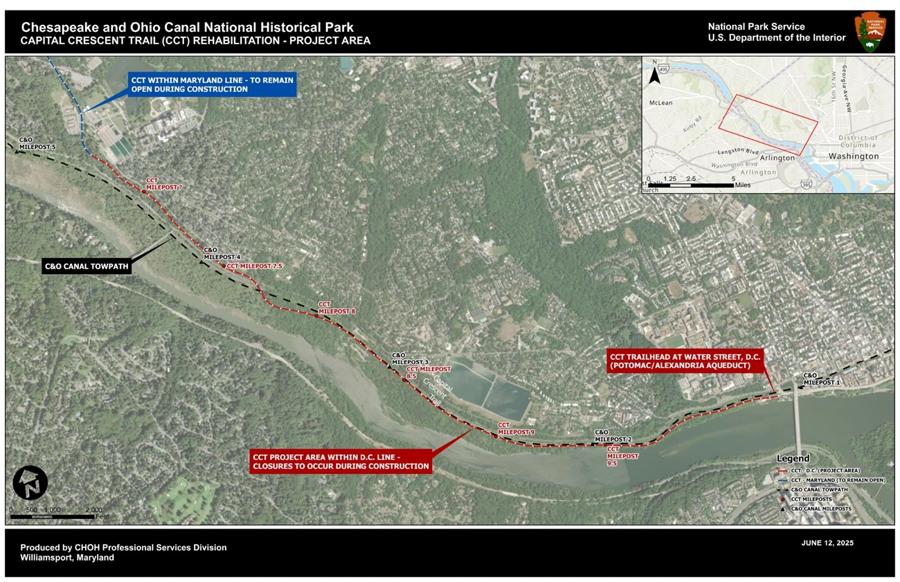
NPS | Professional Services Division – C&O Canal National Historical Park The CCT between the Maryland/DC line and the Water Street, DC, trailhead (approximate CCT mile 6.7 to 10.4) is open.The National Park Service (NPS) plans to rehabilitate 3.7 miles of the Capital Crecent Trail (CCT) located between the Maryland/DC line and the Water Street, DC, trailhead at the Potomac/Alexandria Aqueduct. The CCT is a shared-use trail that runs from Georgetown, DC, to Bethesda, MD. The NPS oversees the lower 3.7 miles extending from Georgetown to the MD/DC border. Generally, the project consists of resurfacing the 10-foot wide asphalt pavement surface and reestablishing the 2-foot wide stone dust shoulders throughout the project area. The project will also include signage upgrades, trail striping, slope stabilization, replacement of deteriorated retaining wall and railings, and repairs to the Arizona Avenue Bridge. The design of the entire 3.7-mile section is currently in progress, and the construction of the project is anticipated to begin in phases starting in 2027. During construction, sections of the CCT will be closed as the work is performed in phases. Trail users will be detoured around the work zones to the adjacent Chesapeake & Ohio (C&O) Canal Towpath and neighboring, low-volume roads. This webpage will be updated with the latest information on the project schedule, closures, and detours. The alignment of the trail is situated within the bed of the former Georgetown Branch of the Baltimore & Ohio Railroad, which operated from 1910 until 1985. The NPS acquired the right-of-way to the lower 3.7 miles in the 1990s and subsequently constructed the paved, shared-use trail as it currently exists in 1994. The existing condition of the CCT is exhibiting signs of deterioration due to vegetative root infiltration into the pavement wearing course, deteriorated timber retaining walls and railings, eroded slopes, worn out striping, and broken/missing signage. According to trail counter data, the CCT is one of the most heavily trafficked rail trails in the United States. This project to rehabilitate the trail and its associated features is critical for providing sustainable infrastructure for current and future users. 
NPS | Professional Services Division – C&O Canal National Historical Park 
NPS | Professional Services Division – C&O Canal National Historical Park CURRENT DETOURS AND CLOSURESThe CCT between the Maryland/DC line and the Water Street, DC, trailhead (approximate CCT mile 6.7 to 10.4) is open. Detours are currently being developed as part of the ongoing design effort and will be posted to this webpage when available. The extent of trail rehabilitation is shown in the mapping below. Visitors are asked to follow the signage and exercise caution around work areas. FREQUENTLY ASKED QUESTIONS (FAQs)What is the need for the project?The existing condition of the CCT exhibits signs of deterioration, due to nearly three decades of heavy use since the trail was originally constructed in 1994. The deficiencies include a compromised asphalt wearing surface, deteriorated railings and retaining walls, broken/missing signage, and encroaching vegetation. What does the project include?Generally, the project consists of resurfacing the 10-foot wide asphalt pavement surface and reestablishing the 2-foot wide stone dust shoulders throughout the project area. The project will also include signage upgrades, trail striping, slope stabilization, replacement of deteriorated retaining wall and railings, and repairs to the Arizona Avenue Bridge. While design of the entire 3.7-mile long section is currently underway, the project is being developed with a core scope of work component and a series of options that may be awarded for construction in phases, depending upon funding and bids received. The National Park Service (NPS) anticipates the contractor to mobilize many various types of heavy equipment to perform the work. Where will the project take place?This project will take place on approximately 3.7 miles of the CCT from the Maryland/DC line to the Water Street, DC, trailhead (approximate CCT mile 6.7 to 10.4). When will the project begin and end?Site work for the construction will begin in 2027 and is anticipated to continue through completion, weather dependent. Schedule updates for construction will be posted to this webpage. How will this project impact park visitors?To facilitate the work, sections of the CCT between the Maryland/DC border will be closed in phases. Detours will be provided in advance and updated to this website.
How will this project benefit park visitors?Once the project is complete, this portion of the heavily used trail system will be rehabilitated. Many existing deficiencies will be addressed, resulting in a safer and more enjoyable visitor experience. How will this project impact natural and cultural resources?Every project the NPS executes undergoes review by a multidisciplinary team to ensure compliance with Section 106 of the National Historic Preservation Act (NHPA), National Environmental Policy Act (NEPA), and other federal, state, and local laws. What is the park doing to protect those resources during the project?NPS resource protection experts, engineers, and the contractor’s team will be monitoring the CCT rehabilitation work along with contractor operations and visitor safety during the project with the goal of safely protecting the environment surrounding the project. During the design phase relocation of some in-stream resources were identified and relocated outside of the work area. How is the project funded?The rehabilitation of the 3.7 miles of the Capital Crescent Trail will be funded through the Federal Lands Transportation Program (FLTP) and a Transportation Alternative Program (TAP) Grant from the District of Columbia. The Federal Highway Administration (FHWA) – Eastern Federal Lands Highway Division will be administering the project design and construction. Total project cost estimates are currently being developed as part of the project design effort. Who can I contact if I have further questions regarding the project?Additional questions are to be directed to the park headquarters at 301-739-4200. 
NPS | Professional Services Division – C&O Canal National Historical Park 
NPS | Professional Services Division – C&O Canal National Historical Park |
Last updated: January 15, 2026
