
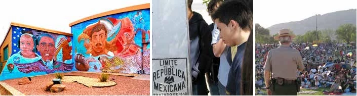
Side 1: ChamizalChamizal National Memorial celebrates the peaceful settlement of a dispute over the international boundary at El Paso, Texas, and Ciudad Juárez in Mexico. On August 29, 1963, after decades of arguing about who owned a piece of land shaped and reshaped by the meandering Rio Grande river, the question was finally settled by diplomacy and technology. The river was constrained within a concrete channel for 4.3 miles, forming a permanent boundary between the two nations. The United States set aside a portion of the former Mexican land received through the Chamizal Convention, or treaty, for recreational and cultural use. At Chamizal National Memorial, established in 1974, music, visual arts, dance, drama, and shared history form cultural bridges as strong as the steel that spans over the Rio Grande. 
Rio GrandeIn the 1860s a dispute arose over a section of Mexican farmland known as El Chamizal. Its original northern border was the Rio Grande, the international boundary. The trouble was that the river’s course was shifting southward (top map), so did it still belong to Mexico? Years later, a flood control project cut off a loop of the river, creating Cordova Island—a detached part of Mexico now north of the Rio Grande (center map). With the sovereignty of El Chamizal unclear and Mexico’s Cordova Island projecting incongruously into El Paso, tensions rose. In the 1960s, technology came to the rescue: a new concrete-lined channel for the Rio Grande was built, bisecting both El Chamizal and Cordova Island (center and bottom maps). The two nations exchanged land, and people and businesses were relocated. Chamizal National Memorial occupies part of old Cordova Island. The Flow of History
1848The Treaty of Guadalupe Hidalgo ends the US-Mexican War; US gains much of its presentday West. Mexico agrees to recognize the Rio Grande as the Texas-Mexico boundary. 1864Massive flooding alters the course of the Rio Grande, initiating a hundred-year-long dispute about exact position of the international boundary. 
1884International boundary is established at the center of the river’s deepest channel. If river course changes abruptly, the old boundary remains in place. 1895Mexico makes a claim on behalf of Pedro I. Garcia, a landowner in El Chamizal. 
1899River channel is straightened to prevent flooding. This creates Cordova Island, a piece of Mexican agricultural land jutting into US territory. 1911Arbitration of the boundary dispute takes place in downtown El Paso, while blocks away, the Mexican Revolution is underway. 
1920-40Cordova Island becomes a drinking and smuggling haven. Efforts, including construction of a fence by Mexico, are made to address the issues. 
JOHN F. KENNEDY PRESIDENTIAL LIBRARY AND MUSEUM 1962With the Cold War escalating, President John F. Kennedy seeks to secure relations with Mexico and travels to Mexico City to meet with President Adolfo López Mateos. The two heads of state resolve to settle the Chamizal dispute. 1963Chamizal Convention signed. Specifies construction of concrete channel to serve as permanent international boundary. Also divides Cordova Island between the United States and Mexico. 
1968President Lyndon Johnson and President Gustavo Díaz Ordaz meet on the Paso del Norte (Santa Fe Street) Bridge to open new river channel. Side 2: Chamizal Yesterday and Today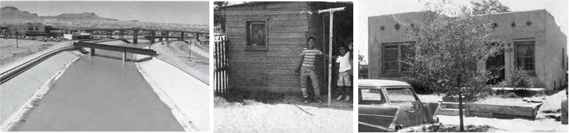

After the Chamizal ConventionThe Chamizal Convention was not just a land swap; thousands of US citizens who lived in the disputed area were forced to relocate, along with businesses, places of worship, schools, and social centers. According to the treaty, the US federal government reimbursed residents for their property, moving, and other expenses. Most structures were demolished. Many Chamizal residents moved to other area neighborhoods while some left for other cities and states. Reaction to the forced relocation was mixed. While people recognized the opportunity to improve their economic conditions or start new lives, they felt injustice and loss when their families and communities were uprooted. These feelings still echo in the hearts and minds of many former Chamizal residents. Both nations have used the exchanged land for improved roads, schools, public buildings, and parks. The US Congress set aside a portion of the old Cordova Island as Chamizal National Memorial. In this setting the National Park Service and other organizations present activities and exhibits celebrating the people who share the borderlands. 
WelcomeStop first at the cultural center. Park staff will answer questions and provide information about the day’s activities and upcoming events. A video presentation introduces the park and its related history and culture. For information about hours and days of operations, visit the park website. Service animals are welcome at the national memorial. The cultural center has museum exhibits, an information desk, park store, 500-seat theater, gallery space, and courtyard with a garden and fountain. The grounds have walking paths. The outdoor stage is just southwest of the cultural center. The park also has picnic areas with tables and grills. 

NPS / ROBERT TOPE For a Safe VisitWatch for traffic while crossing roads and parking areas. Be especially cautious on theater stairs; please use handrails. Find firearms information on the park website. More InformationChamizal National Memorial is one of over 400 parks in the National Park System. Learn more about the National Park Service. To learn more about this park, contact Chamizal National Memorial. 
TheaterThroughout the year, Chamizal’s 500-seat indoor theater comes alive with performances including plays, musicals, modern dance, opera, and ballet folklórico. Park staff and community members also present motion pictures, lectures, and discussions. Outdoor EventsFestivals and programs celebrating the heritage of the borderlands and other special events take place on the park grounds and on the park’s outdoor stage. Franklin G. Smith GalleryExhibits of paintings, drawings, photography, sculpture, and other visual arts fill the Franklin G. Smith Gallery on a periodic basis. Such sharing of the visual arts is intended to promote the spirit of cultural and international cooperation. |
Last updated: January 6, 2022