|
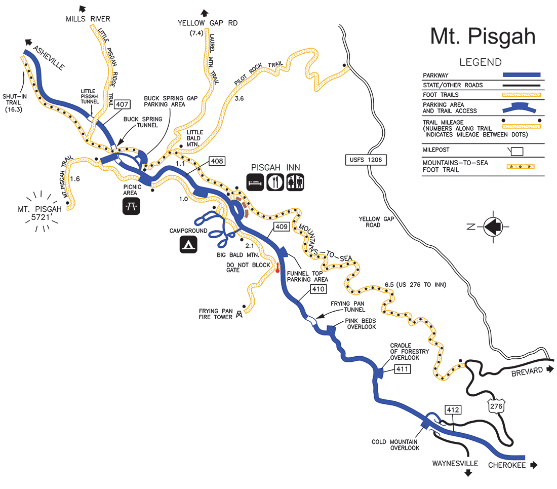
Trails of various lengths and difficulty traverse this area full of natural and historical treasures. Take a leisurely stroll through the surrounding forests or enjoy the challenge of a full day's hike. Whichever you choose, the experience is certain to be rewarding. Mount Pisgah Trail1.6 miles to the summit, begins at the far end of the Mount Pisgah Parking Area. With an ascent of 712 feet, the latter half of the moderate to strenuous hike is fairly steep and rocky. The trail passes through a Northern Red Oak forest to a deciduous heath bald at the summit, which offers a spectacular view including the French Broad River Valley and Shining Rock Wilderness.
Buck Spring TrailThis 1.1 mile-long section of the Mountains-to-Sea Trail runs between the Mount Pisgah Inn and the Buck Spring Gap Parking Area. The trail passes the site where George Vanderbilt's mountain cabin, Buck Spring Lodge, once stood.
Laurel Mountain TrailThis 7.4 mile moderate trail is a spur off the Buck Spring Trail (Mountains-to-Sea Trail). It descends to U.S. Forest Service Road 1206, Yellow Gap Road, about 1,700 feet below.
Pilot Rock TrailThis moderate trail crosses over part of Pilot Rock, a huge rock outcropping used by old-timers as a landmark to get their bearings.
Shut-In TrailThis moderate to strenuous hike of 16.3 miles follows the Mountains-to-Sea Trail. It begins at the Mount Pisgah Parking Area and descends 3,681 feet to Bent Creek near NC 191.
Frying Pan TrailBegins at the entrance to Mt. Pisgah Campground, and crosses through Northern Red Oak "orchards" where the trees are stunted by harsh weather. Groves of shrubby beaked hazelnut, hawthorn, azalea, and tall, shady red spruce, make this trail a favorite among birdwatchers, especially for spring and fall warblers. A moderate to strenuous hike of 2.1 miles, the trail continues into Frying Pan Gap, named for a communal frying pan hung in a tree by mountain herders who camped there. From the Gap, a gravel road leads to a U.S. Forest Service fire tower at the summit, which at 5,450 feet is the trail's end.
|
Last updated: January 27, 2020