Last updated: August 30, 2024
Article
Planning for Resilience: Understanding the Connections Between Forests, Fire, Water, and Drought

NPS Photo
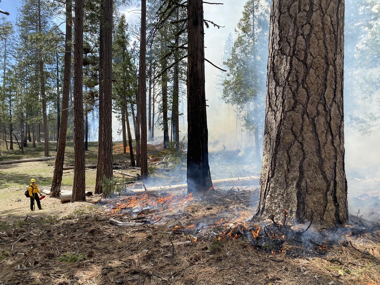
However, in many areas across the Sierra Nevada, including some in Yosemite, forests are dense due to decades of fire suppression that began in the mid-1800s with European colonization. That period also led to a decrease in fires that had been used by Indigenous peoples for millennia to promote healthy forests in Yosemite and elsewhere. Although trees clearly provide important benefits to ecosystems and people, there is a limit on how many trees a landscape like Yosemite can sustain in the long term given the amount of water available and high wildfire risk. Low- and moderate-severity fires play a key role in maintaining dry forests within the park—opening the canopy and allowing water and sunlight through, and reducing the hazardous accumulation of dead, woody debris. Fire also allows for the recycling of nutrients to the soil, which encourages the germination and regrowth of plants.
NPS / Chad Anderson
How did Researchers Conduct the Study?
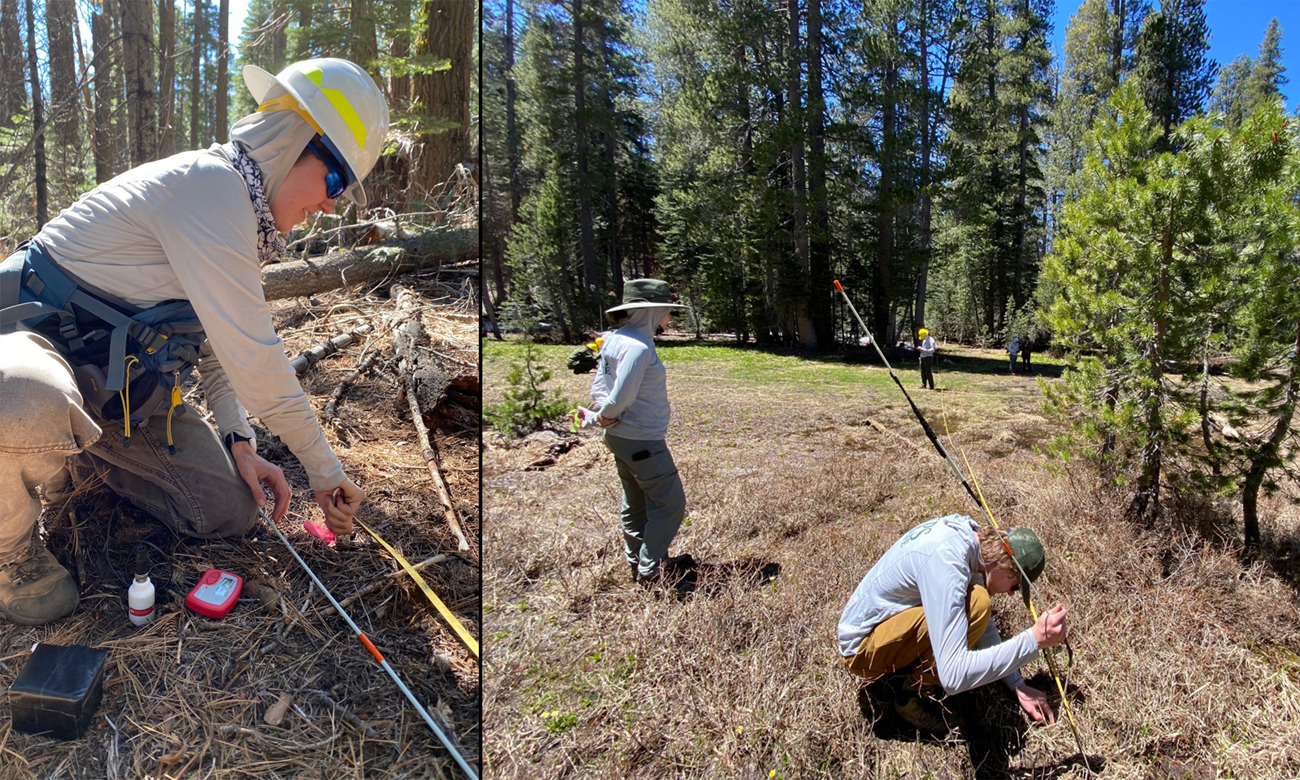
In 2022–2023, researchers used a combination of new field observations, remote sensing, and computer modeling to carry out the study.
- New field observations included measurements of soil moisture, soil water repellency, and infiltration rates. Researchers chose field sites to include a broad range of topography, time since fire, past fire severity, and vegetation density, as well as to span a large portion of western Yosemite National Park. They used statistical models to relate each of the soil property values to topography, vegetation, and fire history. This field work resulted in a unique dataset of soil properties in the park for this and future work.
- Researchers used remote sensing to determine recent vegetation cover. Remote sensing is a surveying method used to collect data about an object from a distance—in this case, the Earth’s surface. They obtained remote sensing information from Lidar and cameras on airplanes.
- Researchers also made use of a multi-year (existing) dataset of snow depth and soil moisture. The dataset included locations under the forest canopy and in adjacent canopy gaps—all along an elevational transect within the park. See Roche et al. (2019) for a description of the dataset.
- Computer modeling—Researchers used models to calculate spatial variations in drought vulnerability and potential fire activity (such as, flame lengths and rate of spread) across the entire western portion of Yosemite. The results were turned into maps identifying areas critical in reducing these threats through management actions. While some models were created explicitly from field observations described above, other simulations of fire, drought stress, and streamflow were provided by Roger Bales at the Center for Ecosystem Climate Solutions (CECS) using models built from satellite data.
NPS / Chad Anderson
Linking Forest Condition and Water Models
It is important to bring the study and management of forests and water together because they are fundamentally connected. Decisions that affect vegetation growth (or removal) will influence how water moves through the landscape (such as how much precipitation evaporates, moves quickly into streams, or seeps into the soil to be available for roots or sustaining streamflows). In turn, these water dynamics will determine how a landscape responds to vegetation changes. Some forested areas might regrow as shrubs following a fire, while others might transition to meadow vegetation or return to forest, depending on how much water is stored in the soil during the growing season. These interactions can be complex, but accounting for them can lead to a more sustainable landscape that better withstands droughts and high-intensity wildfires.
Through its fire management history, Illilouette Creek Basin shows that allowing natural fires can affect the availability of water for plants, wildlife, and people, while reducing drought stress and the intensity of future fires. A more varied landscape (from more frequent fires) also benefits wildlife and plants by providing a wider array of habitats.
What did Researchers Learn?
Forest Density and Snowpack
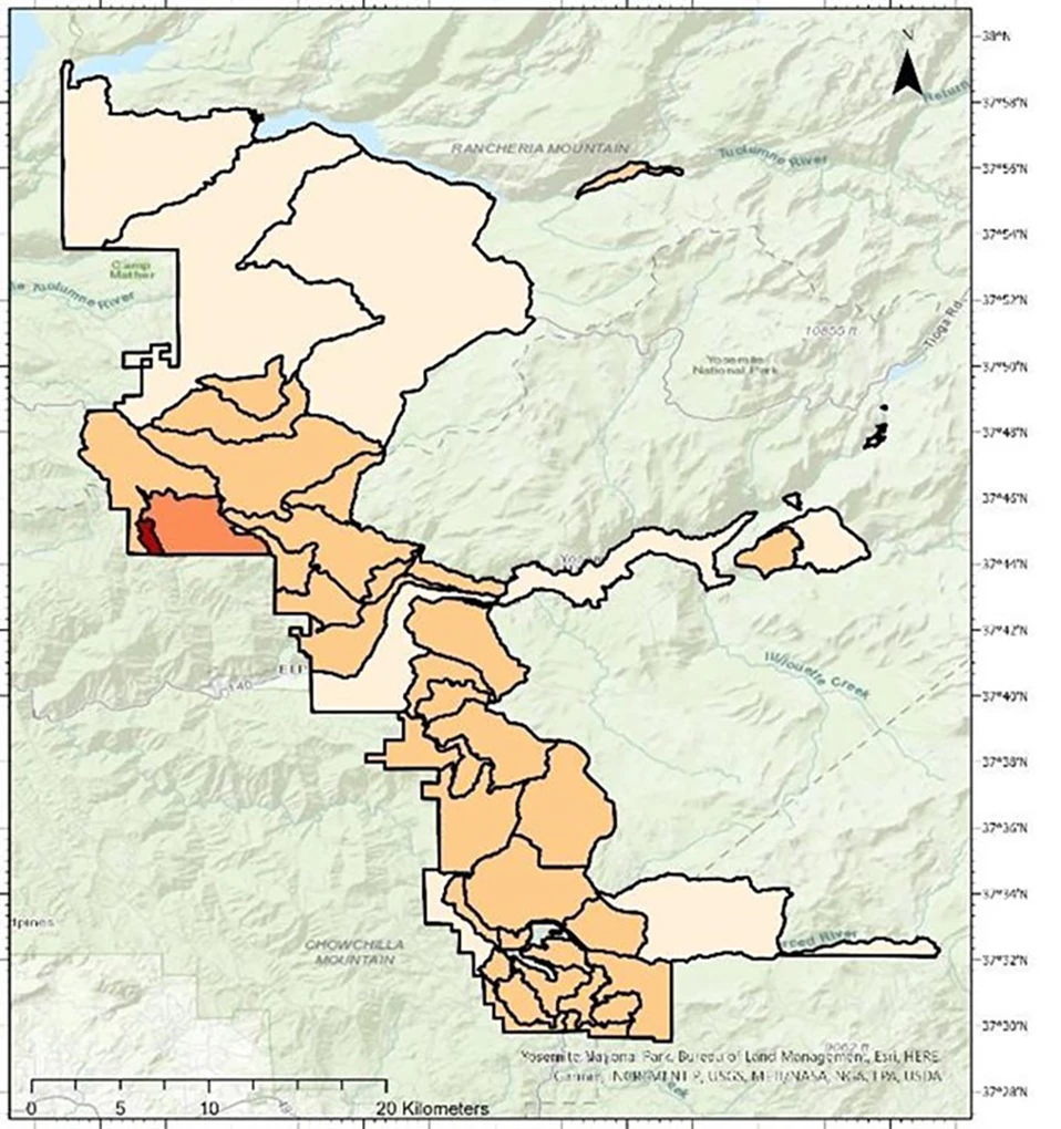
Researchers produced many maps from this work, including Figure 1, which shows forest canopy cover in 2019. The map shows four categories of forest canopy cover, with 75–100% (red in the figure) being the greatest/densest, followed by 50–75% (orange). One can see that areas of densest forest cover are especially in the southwestern portions of the map, but scientists and park managers see something more. They see that the areas in red are the areas with the greatest potential for a reduction in canopy cover (where appropriate), such as through prescribed fire, to achieve multiple benefits. One such benefit is increased snowpack persistence. Snowpack persistence is important because an area’s snowpack stores water as snow during the colder months and gradually releases it as it melts during the warmer months—essentially acting as a reservoir (California Cooperative Snow Surveys Program 2024). Areas with dense forest cover would likely experience long-term snowpack retention benefits with a reduction in canopy cover, because 1) less snow would be trapped in a thinner forest canopy, and 2) less/slower melting would occur due to longwave radiation emitting from dark tree surfaces like tree trunks. Note that the Illilouette Creek Basin (outlined in light blue on the right side of the map) has very little area mapped in red; it has probably achieved relatively healthy levels of forest cover in terms of snowpack.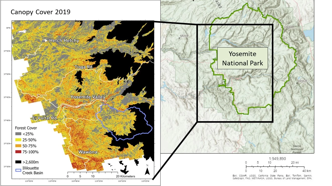
Boisramé et al. (2024—this study)
Drought Stress and Surface Water Runoff
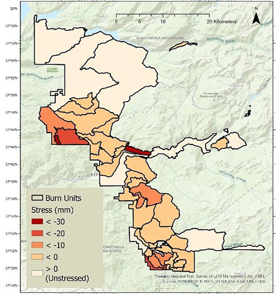
According to model results, researchers found that using prescribed fire across all of Yosemite’s burn units would reduce drought stress (Figure 2) and increase surface water runoff (Figure 3); however, the degree of the effects would vary by location. This finding is consistent with previously published work in the Illilouette Creek Basin (Boisramé et al. 2017, 2019). A burn unit is an organizational unit that park managers use to plan for prescribed fires.Drought stress (or plant water stress) is the amount of water that plants need that is not met by precipitation and stored soil water. Eventually during a drought, trees photosynthesize less (make less food), and this leads to a lack of needed nutrients for survival (Texas A&M Forest Service 2024). When trees do not have the water they need, they become stressed and vulnerable to insect pests, disease, and other threats.
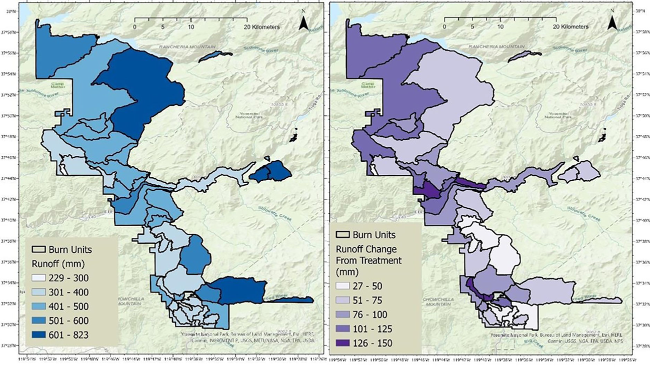
Boisramé et al. (2024—this study), based on models provided by the Center for Ecosystem Climate Solutions (CECS).
Other Important Takeaways of the Study
- During the drought year of 2015, the CECS dataset, which uses satellite imagery and a water balance model to calculate plant water stress, showed higher plant water stress in the southwest part of Yosemite National Park, especially in areas that had not experienced fire in over 20 years.
- Researchers used multiple datasets of snowpack observations to verify that snow persisted longer in open areas compared to under tree canopies within the study area.
- A network of time lapse cameras showed that snow generally melted earlier in forested areas (compared to meadows or shrub fields) in the locations measured.
- Forest management to increase snow retention can also help soil moisture and, therefore, drought resistance.
- Multiple repeat fires are good for water infiltration.
Why are these Findings Important?
While it is widely acknowledged that the forests of Yosemite National Park are denser than they were historically, it can be difficult to quantify how this change has impacted water and forest sustainability. This assessment shows that areas with less tree cover in western Yosemite National Park generally have greater snowpack storage and less drought stress. The analyses suggest that increasing the presence of wildfire on the landscape could reduce the negative impacts of fire on soil properties and alleviate drought stress through increased soil moisture. The CECS models also show the potential to increase streamflow, reduce fire intensity, and reduce drought stress through prescribed fire. The models employed in this study can be used to predict how various management scenarios are most likely to affect different areas in Yosemite National Park.At times, it may seem like there is little we can do regarding climate change, including its effects on precipitation. But keeping snow on the ground longer and reducing the forests’ water needs can help protect our scarce water resources. By using fire as a tool we can manage for more water and encourage more resilient forests, benefitting the entire system, including plants, wildlife, and people. Other research in the park shows that just two fires can help to reduce stress on forests (Hankin and Anderson 2022).
NPS / Paul Bannick
For More Information
- Indigenous Fire Practices Shape our Land: An article about Indigenous peoples’ use of fire for millennia.
- Forest Restoration at Yosemite National Park
- Fire Management at Yosemite National Park overview, with links to related topics, such as Fire Ecology and Monitoring and Fire History.
Glossary of Terms (in order of use in the text):
- Soil moisture is the amount of water in the soil, usually measured as the proportion of a given volume of soil that is filled with water.
- Soil water repellency (or Hydrophobicity) is the property of being water-repellent. If something is hydrophobic (in this case the soil), then it tends to repel water rather than absorb it. This can lead to flooding and erosion during rainstorms, as well as less water reaching the roots of plants.
- Infiltration is the process of water soaking or moving slowly into the soil.
- Topography refers to the physical features of the land, especially the land surface, such as mountains, hills, valleys, and rivers.
- Fire severity “refers to the effects of a fire on the environment, typically focusing on the loss of vegetation both above ground and below ground but also including soil impacts” (Northwest Fire Science Consortium 2024).
- Remote sensing is a surveying method used to collect data about an object from a distance—in this case, the Earth’s surface.
- Snowpack is the snow that accumulates on the ground, storing water in the form of snow during the colder months and gradually releasing it as it melts during the warmer months.
- Drought stress (or plant water stress) is the amount of water that plants need that is not met by precipitation and stored soil water.
- Surface water runoff is precipitation that runs off the land (rather than evaporating or seeping into the ground).
This article is based on the following report, funded in part by the NPS Natural Resource Condition Assessment Program:
Boisramé, G., C. Anderson, and C. Fong. 2024. Assessing Landscape Vulnerability to Drought and Megafires using Linked Forest Condition-Water Models to Guide Resilience Planning. Final Report. Desert Research Institute and National Park Service.References
Boisramé, G. F. S., S. Thompson, B. Collins, and S. Stephens. 2017. Managed wildfire effects on forest resilience and water in the Sierra Nevada. Ecosystems 20(4).Boisramé, G. F. S., S. E. Thompson, C. L. Tague, and S. L. Stephens. 2019. Restoring a natural fire regime alters the water balance of a Sierra Nevada catchment. Water Resources Research 55(7): 5751–5769. Available at https://doi.org/10.1029/2018WR024098.
California Cooperative Snow Surveys Program. 2024. Why is snowpack so important in California? Webpage of the California Department of Water Resources, available at https://snow.water.ca.gov/why#:~:text=Water%20Supply,meltwater%20during%20the%20warmer%20months. Accessed 24 June 2024.
Collins, B. M., J. D. Miller, A. E. Thode, M. Kelly, J. W. Van Wagtendonk, and S. L. Stephens. 2009. Interactions among wildland fires in a long-established Sierra Nevada natural fire area. Ecosystems 12(1): 114–128.
Hankin, L. E., and C. T. Anderson. 2022. Second-entry burns reduce mid-canopy fuels and create resilient forest structure in Yosemite National Park, California. Forests 13(9), 1512. Available at https://www.mdpi.com/1999-4907/13/9/1512.
Northwest Fire Science Consortium. 2024. Fire Facts: What is fire severity? Fact sheet available at https://www.nwfirescience.org/sites/default/files/publications/Fire%20Severity.pdf. Accessed 1 August 2024.
Roche, J. W., R. Rice, X. Meng, D. R. Cayan, M. D. Dettinger, D. Alden, S. C. Patel, M. A. Mason, M. H. Conklin, and R. C. Bales. Climate, snow, and soil moisture data set for the Tuolumne and Merced river watersheds, California, USA. Earth System Science Data, Volume 11, Issue 1 (101–110), https://doi.org/10.5194/essd-11-101-2019.
Stephens, S. L., S. Thompson, G. Boisramé, B. M. Collins, L. C. Ponisio, E. Rakhmatulina, Z. L. Steel, J. T. Stevens, J. W. van Wagtendonk, and K. Wilkin. 2021. Environmental Research Communications 3 081004. Available at https://iopscience.iop.org/article/10.1088/2515-7620/ac17e2/pdf.
Texas A&M Forest Service. 2022. Newsroom: Drought and trees- explained. Available at https://tfsweb.tamu.edu/content/article.aspx?id=32310. Accessed 24 June 2024.
