Last updated: March 19, 2025
Article
Climate and Water Monitoring at Coronado National Memorial: Water Year 2022
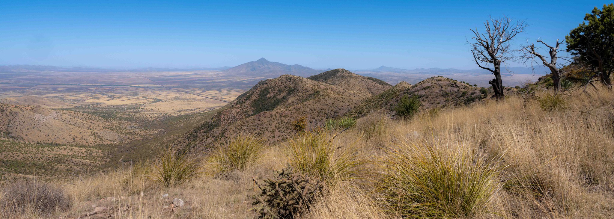
Coronado National Memorial.
Overview
Together, climate and hydrology shape ecosystems and the services they provide, particularly in arid and semi-arid ecosystems. Understanding changes in climate, groundwater, and surface water is key to assessing the condition of park natural resources—and often, cultural resources.
At Coronado National Memorial (NMem) (Figure 1), Sonoran Desert Network scientists study how ecosystems may be changing by taking measurements of key resources, or “vital signs,” year after year—much as a doctor keeps track of a patient’s heart rate and blood pressure over time. This long-term ecological monitoring provides early warning of potential problems, allowing managers to mitigate them before they become worse. At Coronado NMem, we monitor climate, groundwater, and springs, among other vital signs.
Surface-water and groundwater conditions are closely related to climate conditions. Because they are better understood together, we report on climate in conjunction with water resources. Reporting is by water year (WY), which begins in October of the previous calendar year and goes through September of the water year (e.g., WY2022 runs from October 2021 through September 2022).
This article reports on results of climate and water monitoring done at Coronado National Memorial in water year 2022.
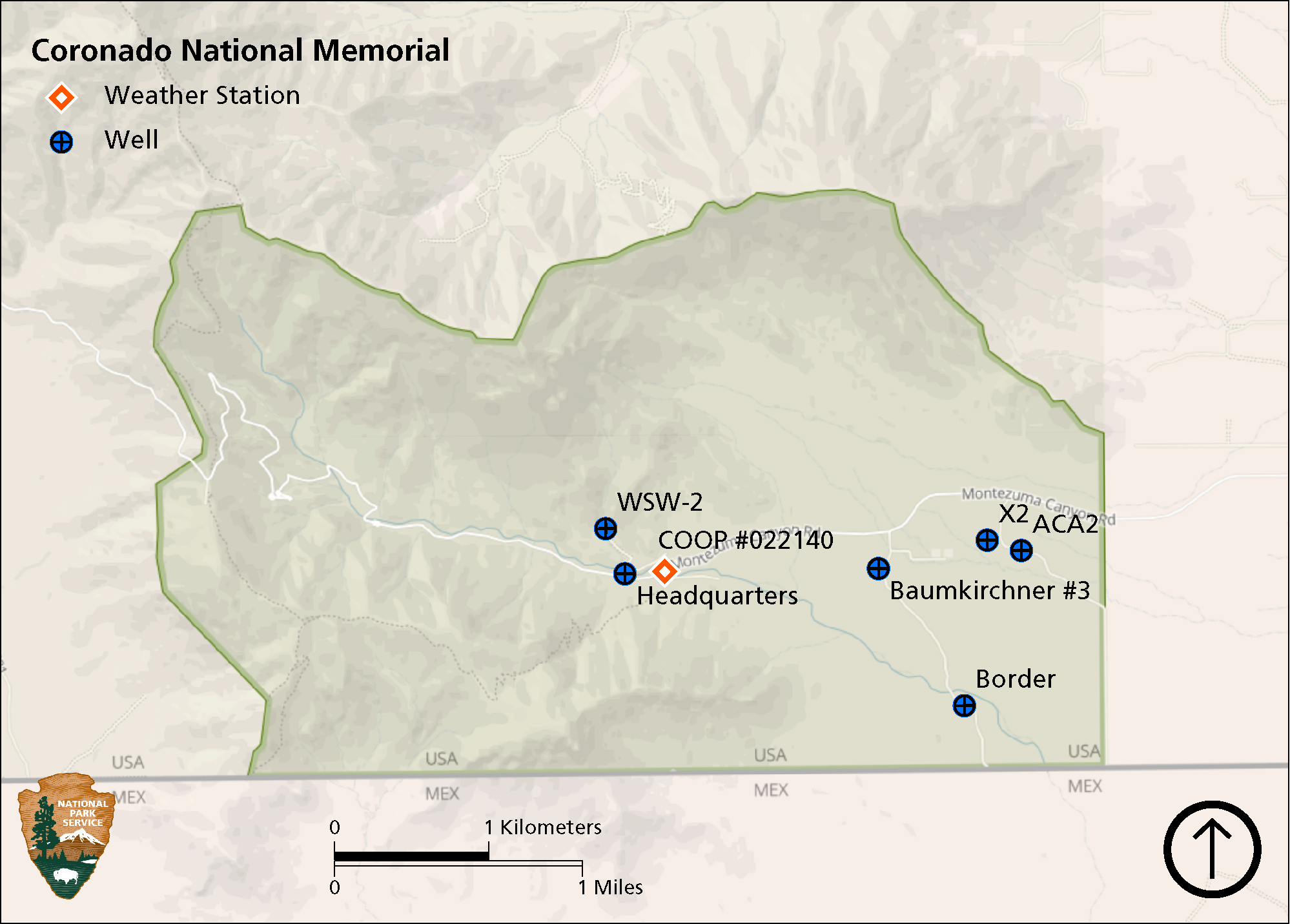
Figure 1. Monitored weather station and groundwater wells at Coronado National Memorial. WSW = water-supply well. COOP = National Weather Service Cooperative Observer station.
Climate and Weather
There is often confusion over the terms, “weather” and “climate.” In short, weather describes instantaneous meteorological conditions (e.g., it’s currently raining or snowing, it’s a hot or frigid day). Climate reflects patterns of weather at a given place over longer periods of time (seasons to years). Climate is the primary driver of ecological processes on earth. Climate and weather information provide context for understanding the status or condition of other park resources.
Methods
Since 1960, Coronado NMem has operated a National Oceanic and Atmospheric Administration (NOAA) Cooperative Observer Program (COOP) weather station (CORONADO NMEM #022140, see Figure 1). This station provides a reliable, long-term climate dataset used for analyses in this climate and water report. Data from this station are accessible through Climate Analyzer.
Findings for Water Year 2022
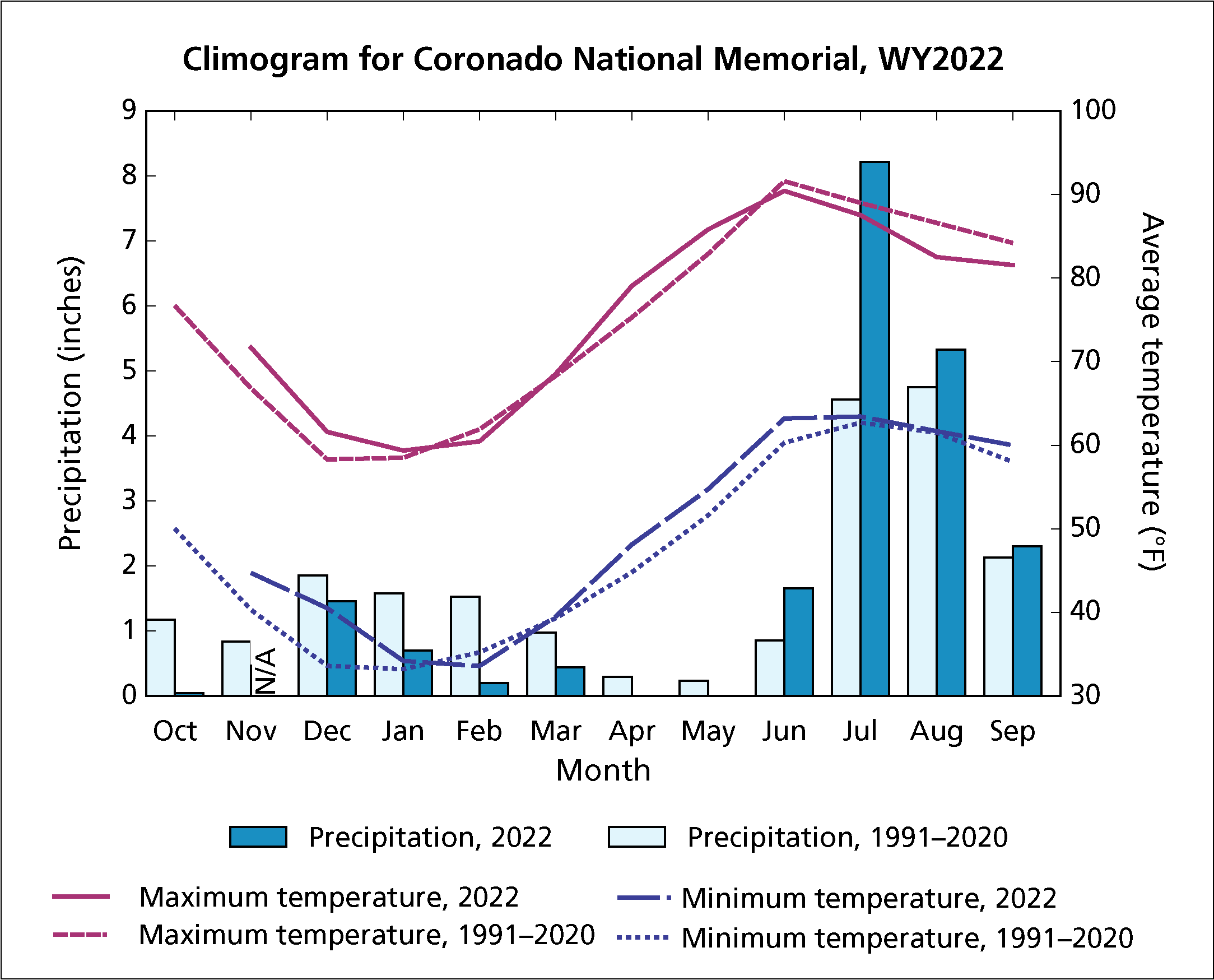
Figure 2. Climogram showing monthly precipitation and mean maximum and minimum temperature, WY2022, and the 1991–2020 means at Coronado National Memorial. Maximum and minimum temperature and precipitation are not shown in October, due to missing data. “N/A” = insufficient data to generate reliable estimates. Data source: Climate Analyzer.
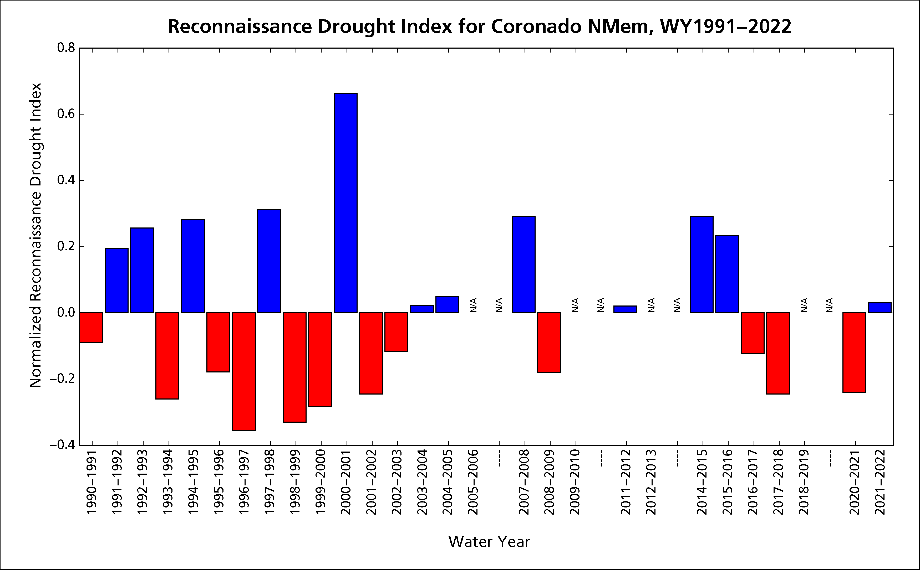
Figure 3. Reconnaissance drought index for Coronado National Memorial, WY1991–2022. Drought index calculations are relative to the time period selected (1990–2022). Choosing a different set of start/end points may produce different results. Data source: Climate Analyzer.
Precipitation
- Annual precipitation at Coronado NMem in WY2022 was 20.6" (52.3 cm; Figure 2), which was 0.17" (0.4 cm) less than the 1991–2020 average.
- Precipitation was below monthly averages for most of the year, except during the monsoon season.
- Rainfall in June and July was nearly twice the average monthly rainfall.
- Extreme daily rainfall events (>1"; 2.54 cm) occurred on six days in WY2022, which was more than the average annual frequency (4.4 days). Extreme rainfall events occurred on:
- December 31, 2021 (1.05"; 2.7 cm),
- July 4, 2022 (1.20"; 3.1 cm),
- July 20, 2022 (1.15"; 2.9 cm),
- July 21, 2022 (1.30"; 3.3 cm),
- August 21, 2022 (1.50"; 3.8 cm), and
- September 21, 2022 (1.69"; 4.3 cm).
Air temperature
- The mean annual maximum air temperature at Coronado NMem in WY2022 was 75.5°F (24.2°C), which was 0.5°F (0.3°C) warmer than the annual average for 1991–2020.
- Mean annual minimum air temperature was 49.6°F (9.8°C), which was 2.1°F (1.2°C) warmer than average (Figure 2).
- Mean monthly maximum and minimum air temperatures also followed this warmer pattern, except in February and during the summer monsoon months, which were slightly cooler than the 1991–2020 averages.
- Extremely hot temperatures (>94°F; 34.4°C) in WY2022 occurred on 7 days, less than half of the average frequency (18.3 days) from 1991 to 2020.
- Extremely cold temperatures (<26°F; −3.3°C) occurred on 10 days, less than the average frequency (13.9 days) for 1991–2020.
Drought
Reconnaissance drought index (Tsakiris and Vangelis 2005) provides a measure of drought severity and extent relative to the long-term climate. It is based on the ratio of average precipitation to average potential evapotranspiration (the amount of water loss that would occur from evaporation and plant transpiration if the water supply was unlimited) over short periods of time (seasons to years). The reconnaissance drought index for Coronado NMem indicates that WY2022 was slightly wetter than the 1991–2022 average, from the perspective of both precipitation and potential evapotranspiration (Figure 3).
Groundwater
Groundwater is one of the most critical natural resources of the American Southwest. It provides drinking water, irrigates crops, and sustains rivers, streams, and springs throughout the region. Groundwater is closely linked to long-term precipitation and surface waters, as ephemeral flows sink below ground to reappear months, years, or even centuries later as perennial and intermittent streams and springs. Groundwater also sustains vegetation and is the primary source of water for almost all humans in the southwestern U.S. Groundwater therefore interacts either directly or indirectly with all key ecosystem features of the arid Sonoran Desert ecoregion.
Methods
At Coronado NMem, groundwater is monitored using six wells (see Figure 1 in the Overview). SODN currently monitors five wells: two using automated methods (ACA-3 and Border) and three using manual methods quarterly (WSW-2, Headquarters, and X-2). The US Geological Survey (USGS) monitors a sixth well, Baumkirchner #3, using automated methods. USGS data for Baumkirchner #3 is available at USGS 312044110141901.
Results for Water Year 2022
Groundwater monitoring results for WY2022 are summarized in Table 1. Well-water levels are shown in Figures 4–6 and grouped by depth-to-water rather than geographic proximity or wellhead elevation.
- Mean depth-to-water at the Headquarters well in WY2022 was higher than in WY2021 (Table 1; Figure 4). Groundwater levels in the other five wells were lower in WY2022 than in the previous water year. However, all were within their historic monitoring records.
- Water levels in the Headquarters well are highly variable, likely increasing in response to runoff events in Montezuma Canyon Wash (Figure 4).
- Water levels in Baumkirchner #3 are relatively stable but exhibit seasonal fluctuations (Figure 4).
- X2 water levels have exhibited low variability over the monitoring record, likely due to the alignment of the aquifer’s geologic formation (Figure 5).
- WSW-2 is the park’s water supply, and pumping can cause nearly 120 feet of drawdown. WSW-2 static water levels have no apparent upward or downward trend (Figure 5).
- Fluctuations in the ACA3 water levels appear to follow those in WSW-2. This may indicate that both aquifers are responding to the same recharge events, although the response at ACA3 is delayed (Figure 5).
- Water levels in the Border well have demonstrated a consistent decline throughout the recent monitoring period (Figure 6).
Table 1. Groundwater monitoring results in water year 2022, Coronado National Memorial.
| Name | State well number | Wellhead elevation (feet amsl)1 | Mean depth-to-water (feet bgs)2 | Mean water-level elevation (amsl feet) | Elevation change from water year 2021 (± feet) | Elevation change from earliest recorded water level (± feet) |
|---|---|---|---|---|---|---|
| Headquarters | 629139 | 5,272.21 | 31.36 | 5,240.85 | 3.91 | 12.64 (1959) |
| Baumkirchner #3 | 629137 | 5,100.00 | 35.52 | 5,064.48 | −0.84 | −6.02 (1998) |
| X2 | 509098 | 5,029.54 | 149.78 | 4,879.76 | −0.52 | −1.47 (2002) |
| WSW-2 | 909747 | 5,454.74 | 212.80 | 5,241.94 | −3.41 | −18.83 (2008) |
| ACA3 | 510144 | 4985.31 | 255.84 | 4,729.47 | −11.16 | 45.16 (1991) |
| Border | 629142 | 4,940.00 | 624.72 | 4,315.28 | −0.32 | 0.18 (1975) |
1amsl = above mean sea level
2bgs = below ground surface
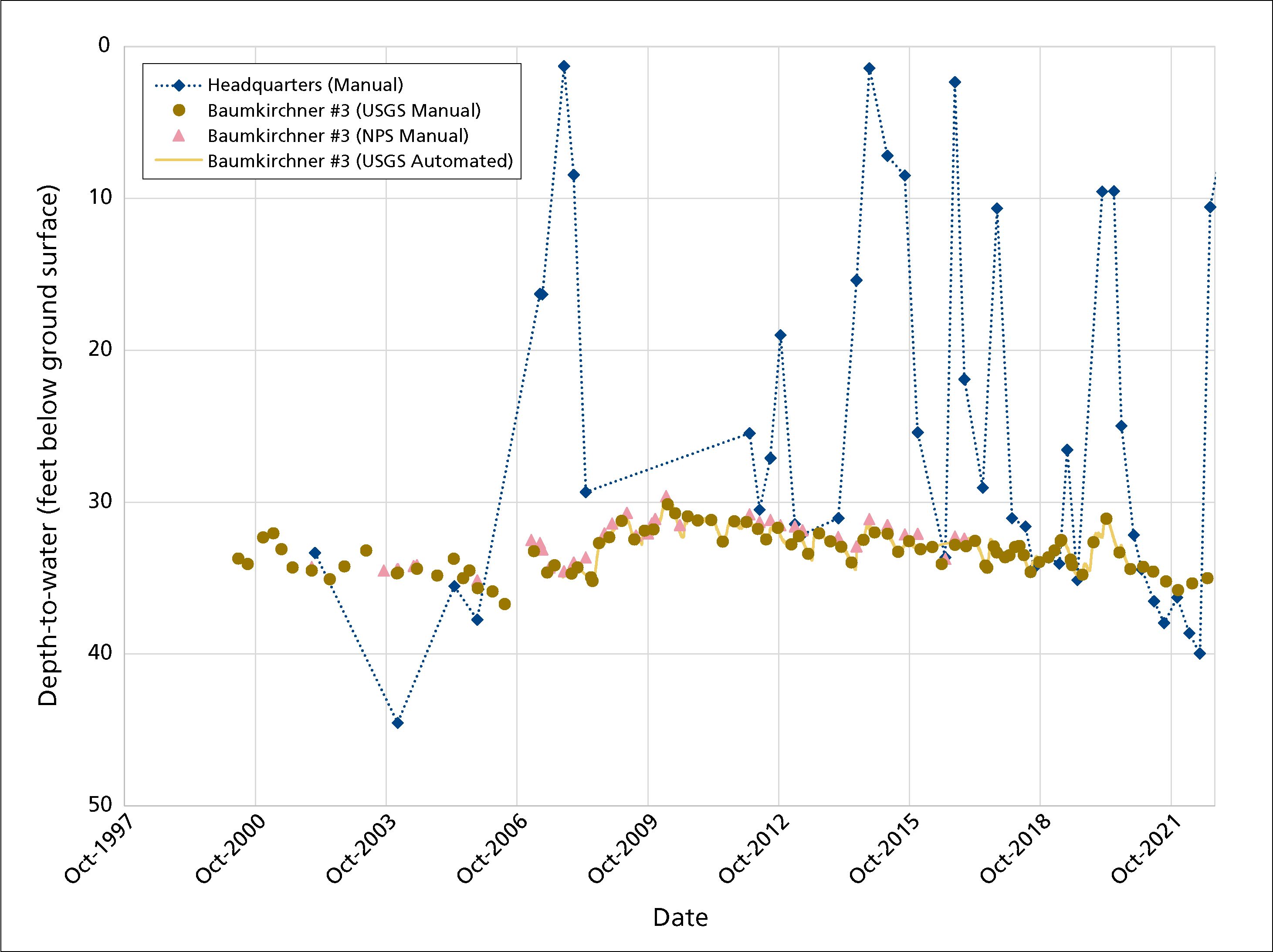
Figure 4. Depth-to-water (feet below ground surface) at Headquarters and Baumkirchner #3 groundwater monitoring wells, Coronado National Memorial, water years 1998–2022.
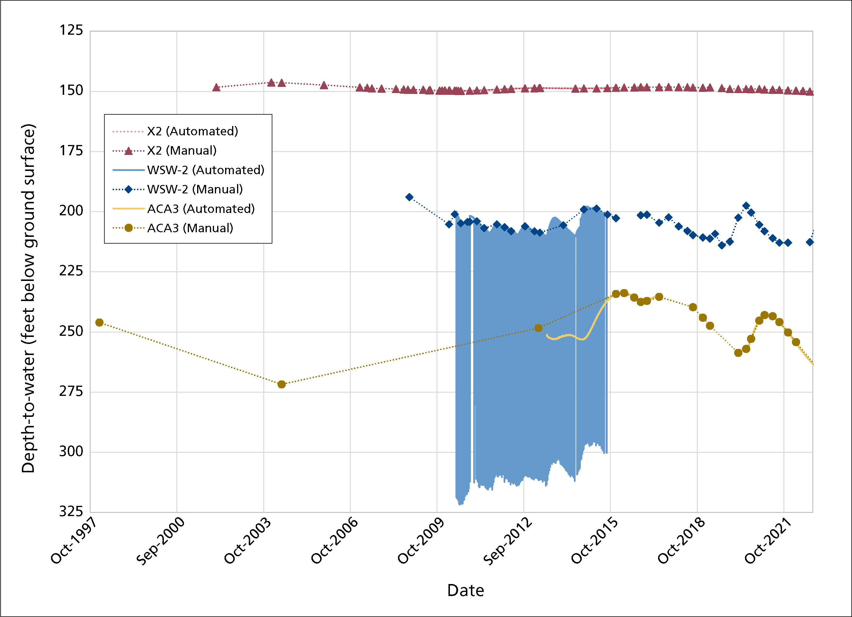
Figure 5. Depth-to-water (feet below ground surface) at X2, WSW-2, and ACA3 groundwater monitoring wells, Coronado National Memorial, water years 1998–2022.
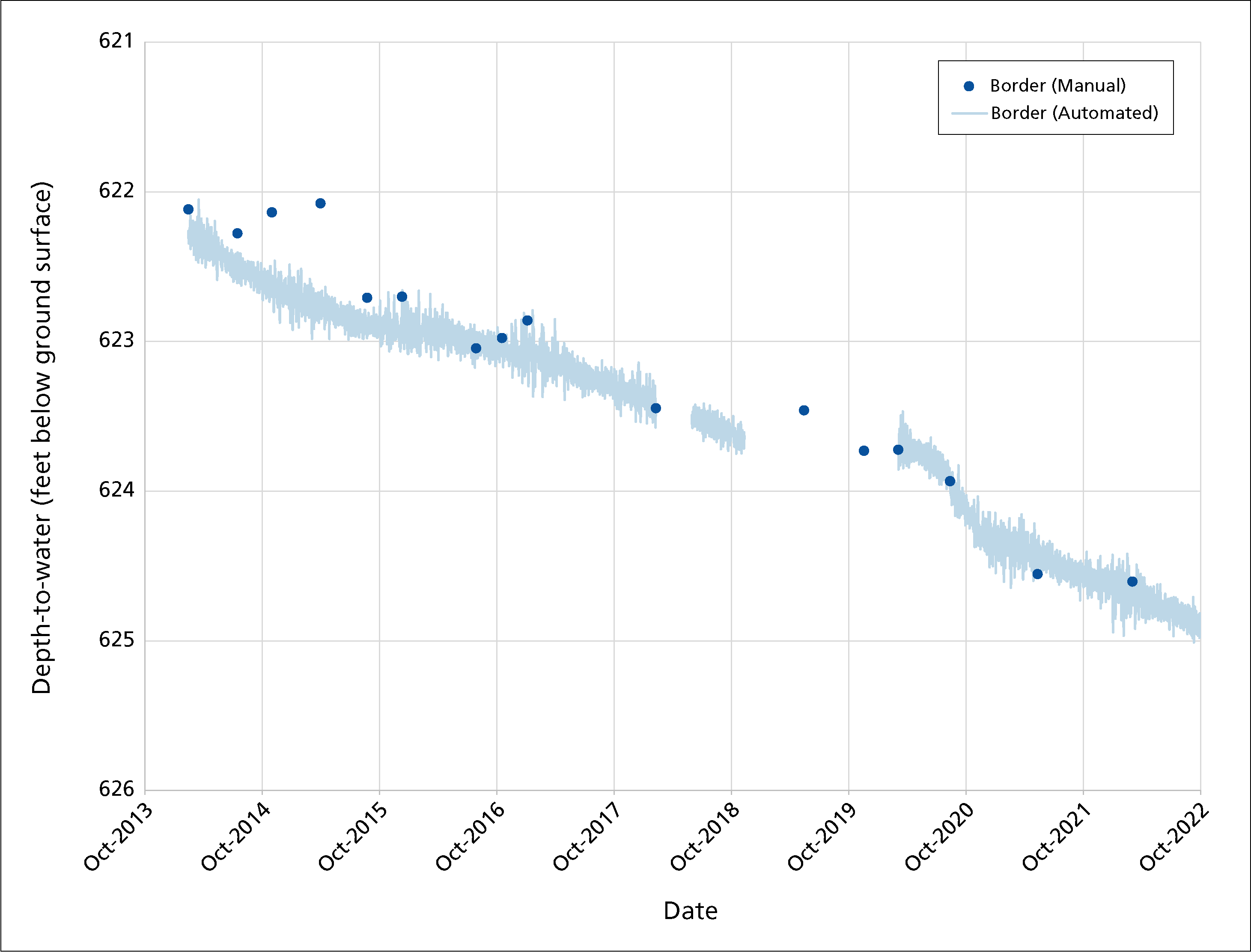
Figure 6. Depth-to-water (feet below ground surface) at the Border groundwater monitoring well, Coronado National Memorial, water years 2014–2022.
Springs
Background
Springs, seeps, and tinajas are small, relatively rare biodiversity hotspots in arid lands. They are the primary connection between groundwater and surface water, and are important water sources for park plants and animals. For springs, the most important questions we ask are about persistence (How long was there water in the spring?), and water quantity (How much water was in the spring?).
Climate change is an emerging impact on springs in the American Southwest. Anticipated changes include increased air temperatures, evaporation rates, and drought intensity; more frequent and extreme rainfall and heat events; and potentially reduced precipitation in the winter and spring. These changes may cause springs to experience reduced flow or even go dry, which may disrupt ecological functions, reduce species diversity, and negatively impact visitor experience.
Sonoran Desert Network springs monitoring is organized into four modules, described below. Results are reported in metric measurements.
Site characterization
This module, which includes recording GPS locations and drawing a site diagram, provides context for interpreting change in the other modules. We also describe the spring type (e.g., helocrene, limnocrene, rheocrene, or tinaja) and its associated vegetation. Helocrene springs emerge as low-gradient wetlands. Limnocrene springs emerge as pools, and rheocrene springs emerge as flowing streams. This module is completed once every five years or after significant events.
Site condition
We estimate natural and anthropogenic disturbances and the level of stress on vegetation and soils on a scale of 1–4, where 1 = undisturbed, 2 = slightly disturbed, 3 = moderately disturbed, and 4 = highly disturbed. Types of natural disturbances can include flooding, drying, fire, wildlife impacts, windthrow of trees and shrubs, beaver activity, and insect infestations. Anthropogenic disturbances can include roads and off-highway vehicle trails, hiking trails, livestock and feral-animal impacts, removal of invasive non-native plants, flow modification, and evidence of human use. We take repeat photographs showing the spring and its landscape context. We note the presence of certain obligate wetland plants (plants that almost always occur only in wetlands), facultative wetland plants (plants that usually occur in wetlands, but also occur in other habitats), and non-native bullfrogs and crayfish, and we record the density of invasive, non-native plants.
Special project: eDNA inventory. In WY2022, SODN implemented an inventory of rare and invasive species and pathogens in perennial springs using environmental DNA (eDNA) techniques. Samples were preserved in ethanol prior to DNA extraction and analysis by the Goldberg Lab at Washington State University. The following rare and invasive species and pathogens were targeted:
- The non-native invasive American bullfrog (Rana catesbeiana), which has been detected near (but not within, to our knowledge) the memorial (Schmidt et al. 2007).
- The pathogen chytrid fungus (Batrachochytrium dendrobatidis), a major threat to amphibians globally that is currently expanding in the American Southwest, but has not been previously detected in the memorial.
- Ranaviruses that can infect amphibians and produce 90–100% mortality in tadpoles and adults and can persist in affected wetlands. Ranaviruses have not been previously detected at the memorial.
- The native amphibian Chiricahua leopard frog (Rana chiricahuensis), a federally designated threatened species which was historically which has been detected near (but not within, to our knowledge) the Memorial (Schmidt et al. 2007). Designated critical habitat is located north of the memorial in the Huachuca Mountains.
- The native amphibian lowland leopard frog (Rana yavapaiensis), a species of conservation concern that has not been previously observed at the memorial (Schmidt et al. 2007).
- The native aquatic northern Mexican garter snake (Thamnophis eques megalops), a federally designated threatened species that has been detected near (but not within, to our knowledge) the memorial (Schmidt et al. 2007), and which has designated critical habitat just west of the memorial boundary.
- The native mammal, jaguar (Panthera onca), a federally designated endangered species historically found within the memorial. All of the memorial lies within designated critical habitat for jaguar recovery.
Water quantity
We measure the persistence of surface water, amount of spring discharge, and wetted extent. To estimate persistence, we analyze the variance of temperature measurements taken by logging thermometers placed at or near the orifice (spring opening). Because water mediates variation in diurnal temperatures, data from a submerged sensor will show less daily variation than data from an exposed open-air sensor; this tells us when the spring was wet or dry. Surface discharge is measured with a timed sample of water volume. Wetted extent is a systematic measurement of the physical length (up to 100 m), width, and depth of surface water. It is assessed using a technique for either standing water (e.g., limnocrene and helocrene springs) or flowing water (e.g., rheocrene springs).
Water quality
We measure core water-quality parameters and water chemistry. Core parameters include water temperature, pH, specific conductivity (a measure of dissolved compounds and contaminants), dissolved oxygen (how much oxygen is present in the water), and total dissolved solids (an indicator of potentially undesirable compounds). Discrete samples of these parameters are collected with a multiparameter meter. If the meter failed calibration check(s), we do not present data. Water chemistry is assessed by collecting surface water sample(s) and estimating the concentration of major ions with a photometer in the field. These parameters are collected at one or more sampling locations within a spring. Data are presented only for the primary sampling location. Each perennial spring is somewhat unique, and there are not water-quality standards specific to most perennial springs in Arizona. Where conditions exceed water-quality standards for other surface waters (rivers, streams, lakes, and reservoirs), we note it, but the reader is advised that these standards were not developed for perennial springs. Our ongoing data collection at each spring will improve our understanding of the natural range in water-quality and water-chemistry parameters for a given site.
Results for Water Year 2022
Blue Waterfall #2
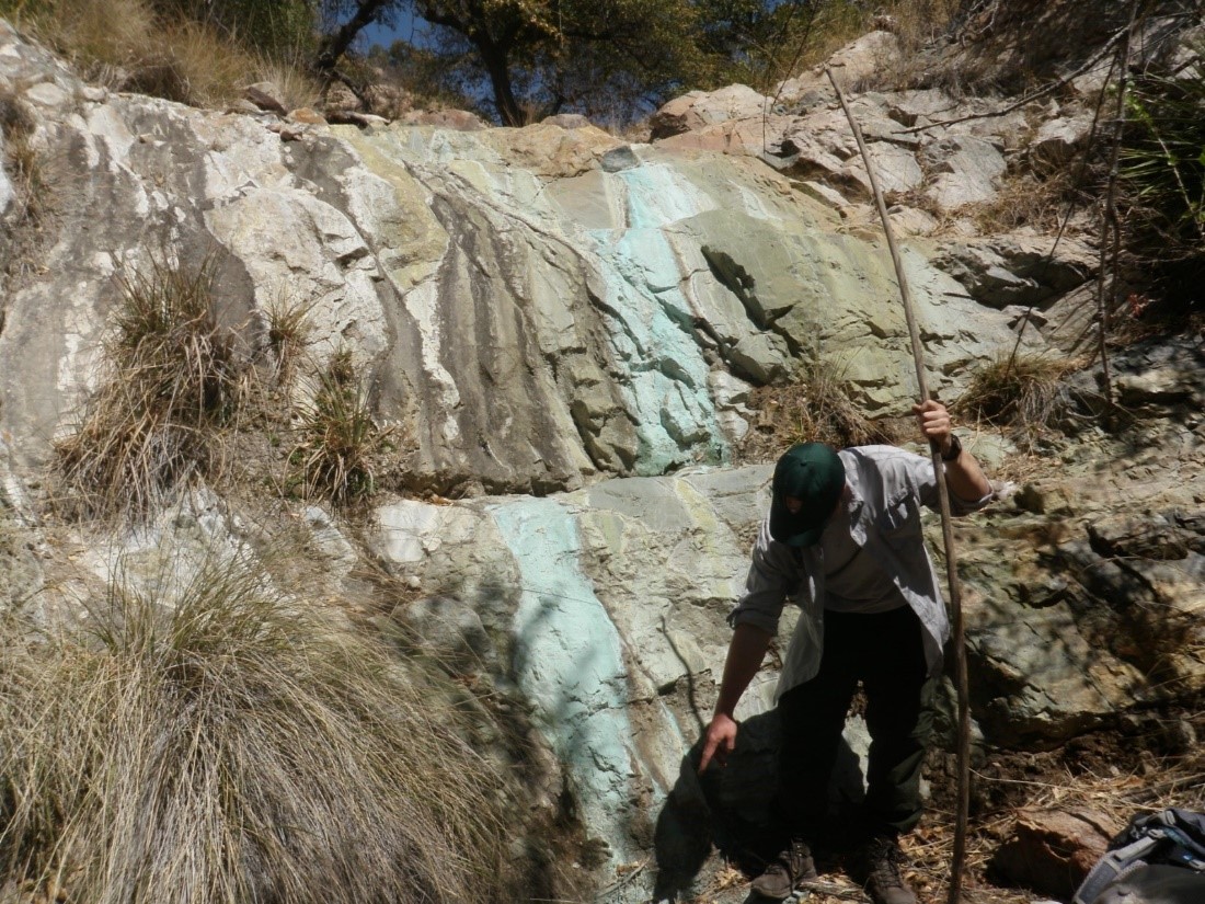
Figure 7. Blue Waterfall #2 at Coronado National Memorial, April 2022. Orifice and pool (where biologist was standing) were dry during visit. NPS photo.
Blue Waterfall #2 (Figure 7) is a rheocrene spring (emerges as a flowing stream) occurring in the middle of a steep, south-facing canyon. Unlike in previous years (2017–2021), the spring was completely dry when sampled on April 6, 2022. As in past years, bright blue water stains occurred on the bedrock cliffs above the dry step pools. Dead branches and other debris were located about one meter up in adjacent trees, and the dry pools contained large amounts of fresh sand, suggesting a major runoff event and sedimentation since the site was sampled in 2021.
Site condition. When visited in WY2022, Blue Waterfall #2 was completely dry—a “highly disturbed” condition due to more extreme drying than in past years. However, fresh deposits of sediment within the main pool, and leaves and other plant debris in tree canopies about one meter above the main pool, suggest recent flooding—likely during the powerful WY2021 summer monsoon season. Discarded water bottles, clothing, and other trash indicated continued “slight disturbance” from contemporary human use of Blue Waterfall #2, as in past years. All other natural and human-caused disturbance types were rated as “undisturbed.”
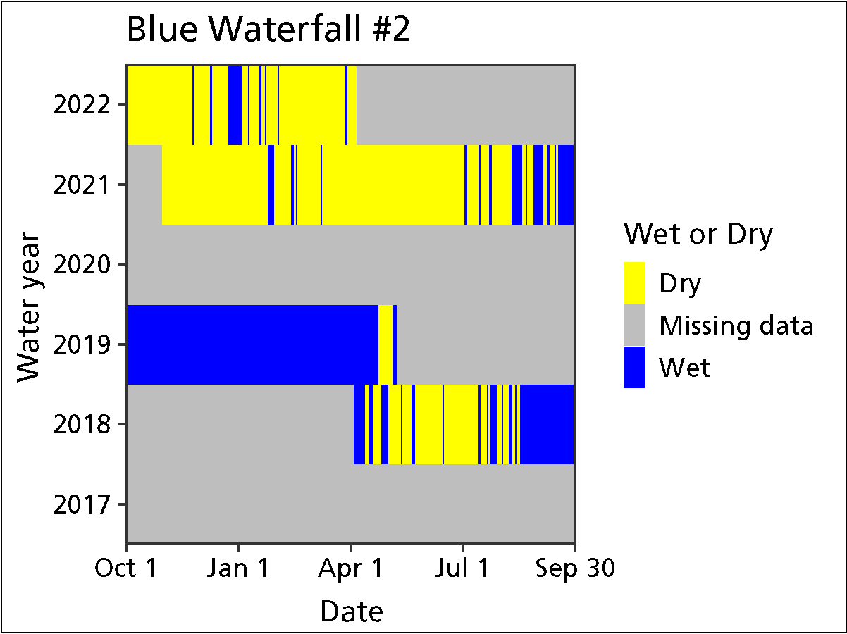
Figure 8. Water persistence in Blue Waterfall #2, Coronado National Memorial.
As in past years, the crew did not observe crayfish or bullfrogs (non-native, invasive aquatic animals) at Blue Waterfall #2, nor did they observe any non-native invasive plants. The crew observed the obligate wetland sedge, Carex sp., as in four of the past five years of sampling.
Water quantity. Because this spring was completely dry when sampled, discharge and wetted extent were not measured. Temperature sensors indicated that Blue Waterfall #2 was “wetted” (contained water) for only 22 (11.7%) of the 188 days measured up to the WY2022 visit (Figure 8). In prior water years, the site was wetted 14.3–94.6% of the days measured and contained sufficient water for discharge and wetted-extent measurements during annual visits.
Water quality. Core water-quality and water-chemistry data could not be collected in WY2022, as the site was completely dry.
Fern Grotto Spring
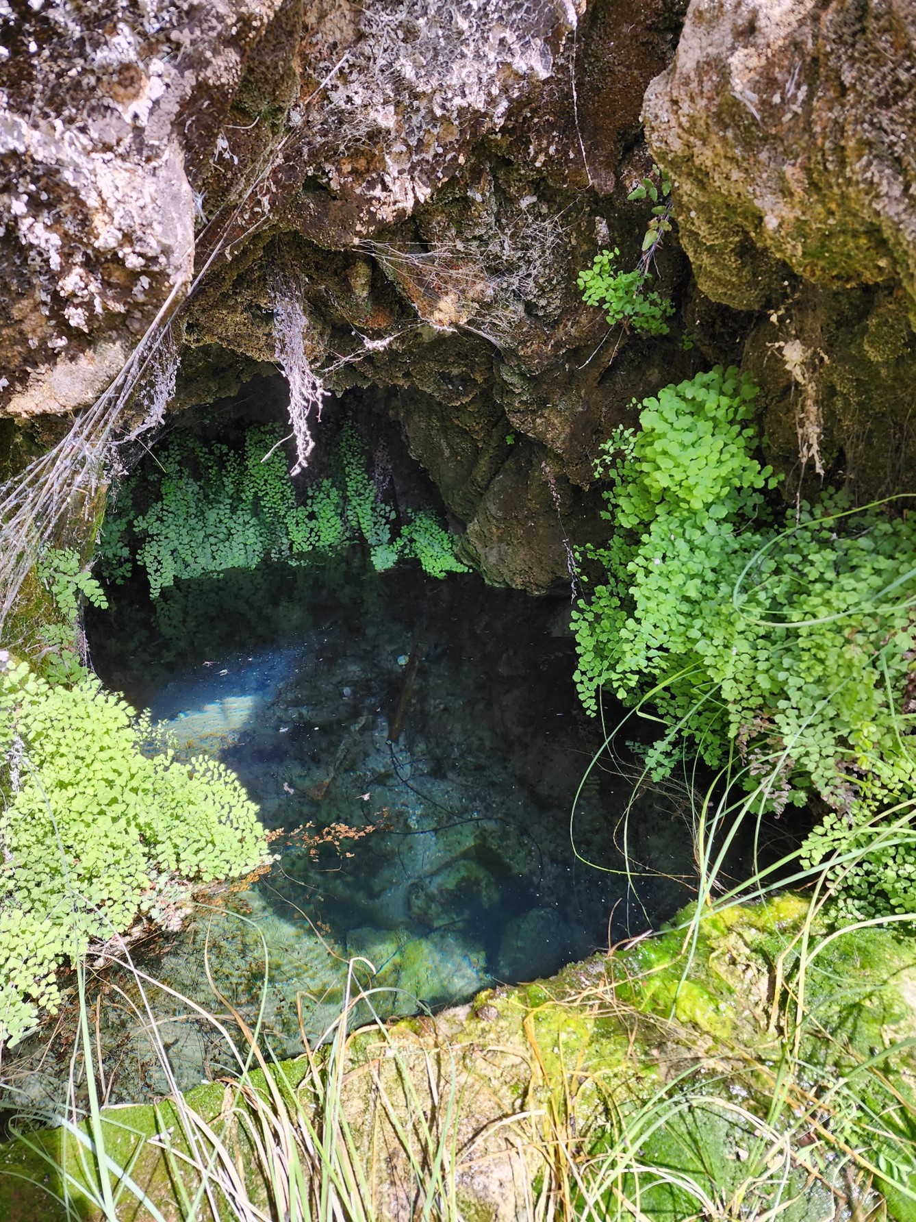
Figure 9. Fern Grotto at Coronado National Memorial, April 2022. NPS photo.
Fern Grotto is a cave spring (emerges entirely within cave and not directly connected to surface flow) that occurs within a 3 × 1.5 × 2-meter cave that is dammed by a one-meter cement wall (Figure 9). When sampled on April 7, 2022, the water was very cold, clear, and still, rising to the lip of the dam. The ceiling and walls of the cave are composed of travertine, and are covered in thick moss, ferns, and monkeyflowers. The cave is in the middle of a steep channel stepping down the south side of a ridge (Figure 10). A second orifice supports a marshy area and small pool (Figure 11) on the slope above the cave. A cattle trough (fed by the spring) and non-functional springbox with pipe are just below. Bees and terrestrial insects are abundant.
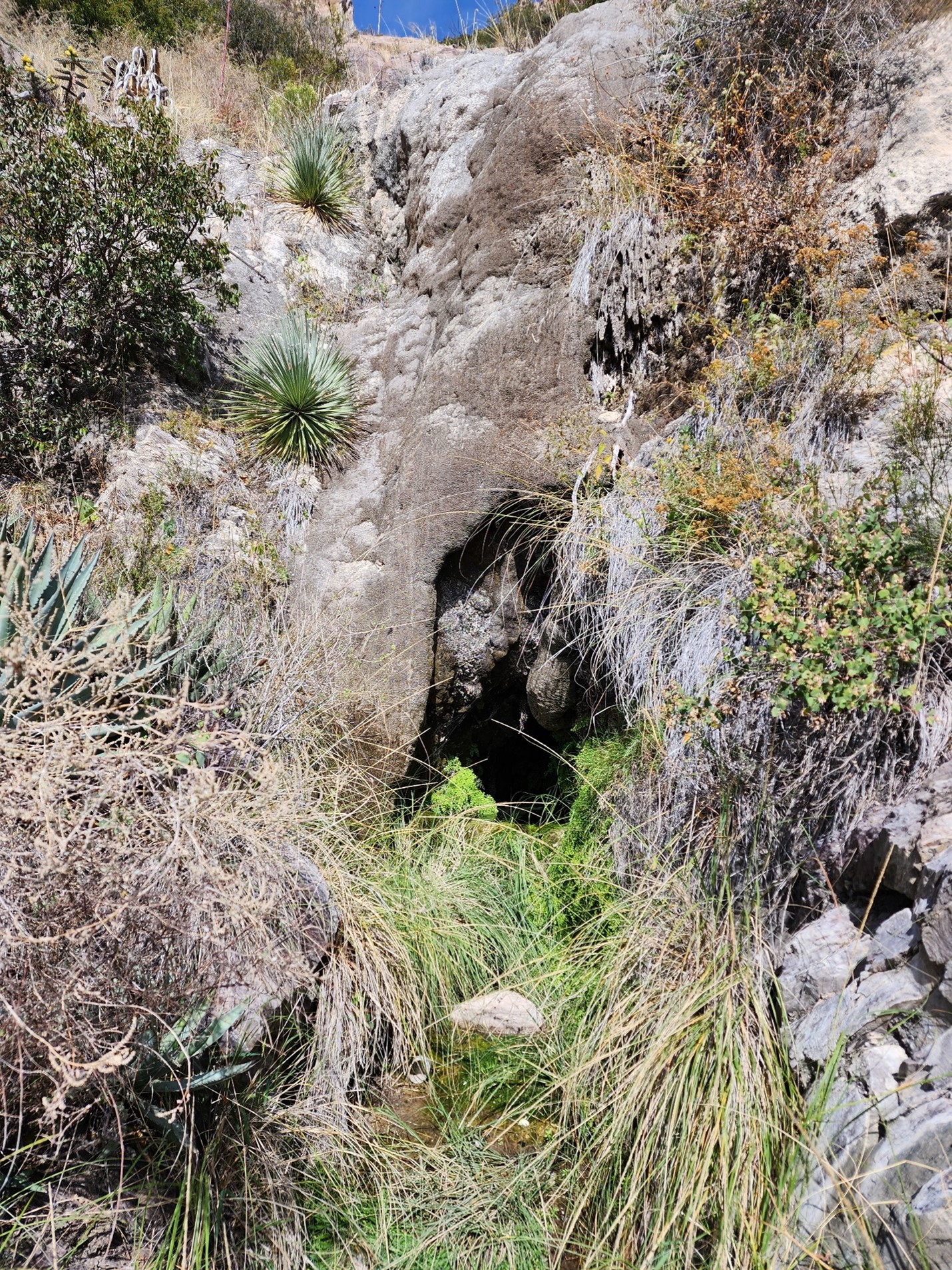
Figure 10. Fern Grotto Cave is located in a steep, south-facing drainage at Coronado National Memorial. A second spring orifice is located on the slope above the cave. NPS photo.
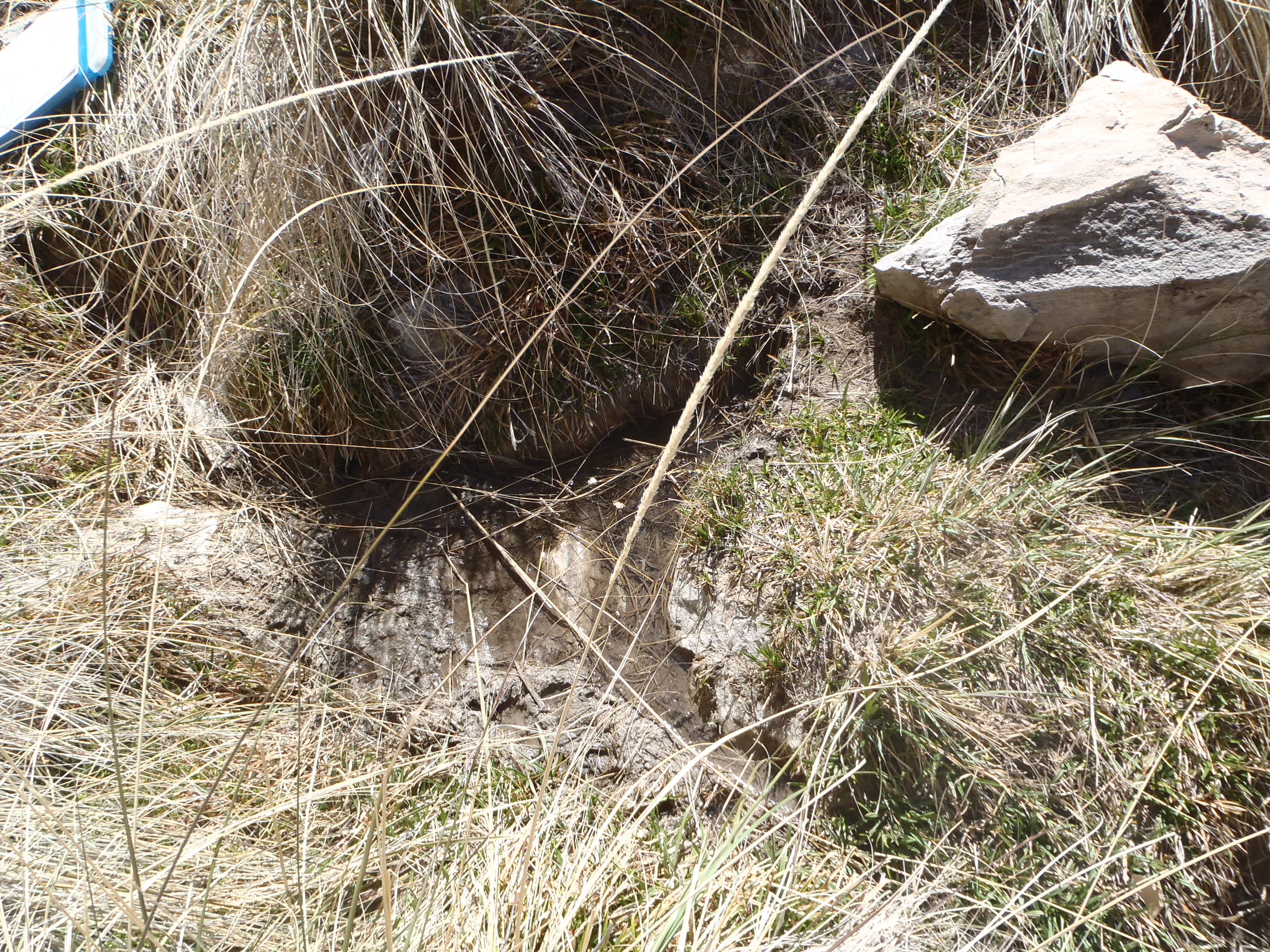
Figure 11. A second orifice to Fern Grotto Spring is located in a marshy area above the cave. NPS photo.
Site condition. In WY2022, disturbance due to human use was greater than in past years. We encountered substantial amounts of scattered trash, discarded clothing, and even human waste around the site, indicating a “highly disturbed” condition. A web of social trails was also observed winding in and around the site, resulting in a “slightly disturbed” rating. These trails were more noticeable and impactful than those observed from 2017 to 2021. The dam, springbox, and cattle troughs still strongly influence springflow and local hydrology despite the cessation of the associated livestock operations decades ago, resulting in a “highly disturbed” condition. As in past years, extensive deer and javelina tracks and other sign (including digging) throughout the site indicate “slight disturbance” due to wildlife use of Fern Grotto—particularly the marshy area around the second orifice and the old livestock trough below the cave.
As in past years, the crew did not observe crayfish or bullfrogs (non-native, invasive aquatic animals) during the April 2022 visit, nor did they detect any non-native plants. The crew observed Fern Grotto’s namesake obligate wetland plant, maidenhair fern (Adiantum sp.), as well as the first observations of monkeyflower (Mimulus sp.) and mule-fat (Baccharis salicifolia) at this site.
Special project: eDNA inventory. Four water samples were collected and filtered (0.45-µm mesh) at Fern Grotto Spring (two from within the cave catchment, two from the abandoned livestock trough) during the April visit. None of our target organisms (see Methods section) was detected. Additional data collection for this inventory is occurring at this site, to be discussed in a future, more detailed report.
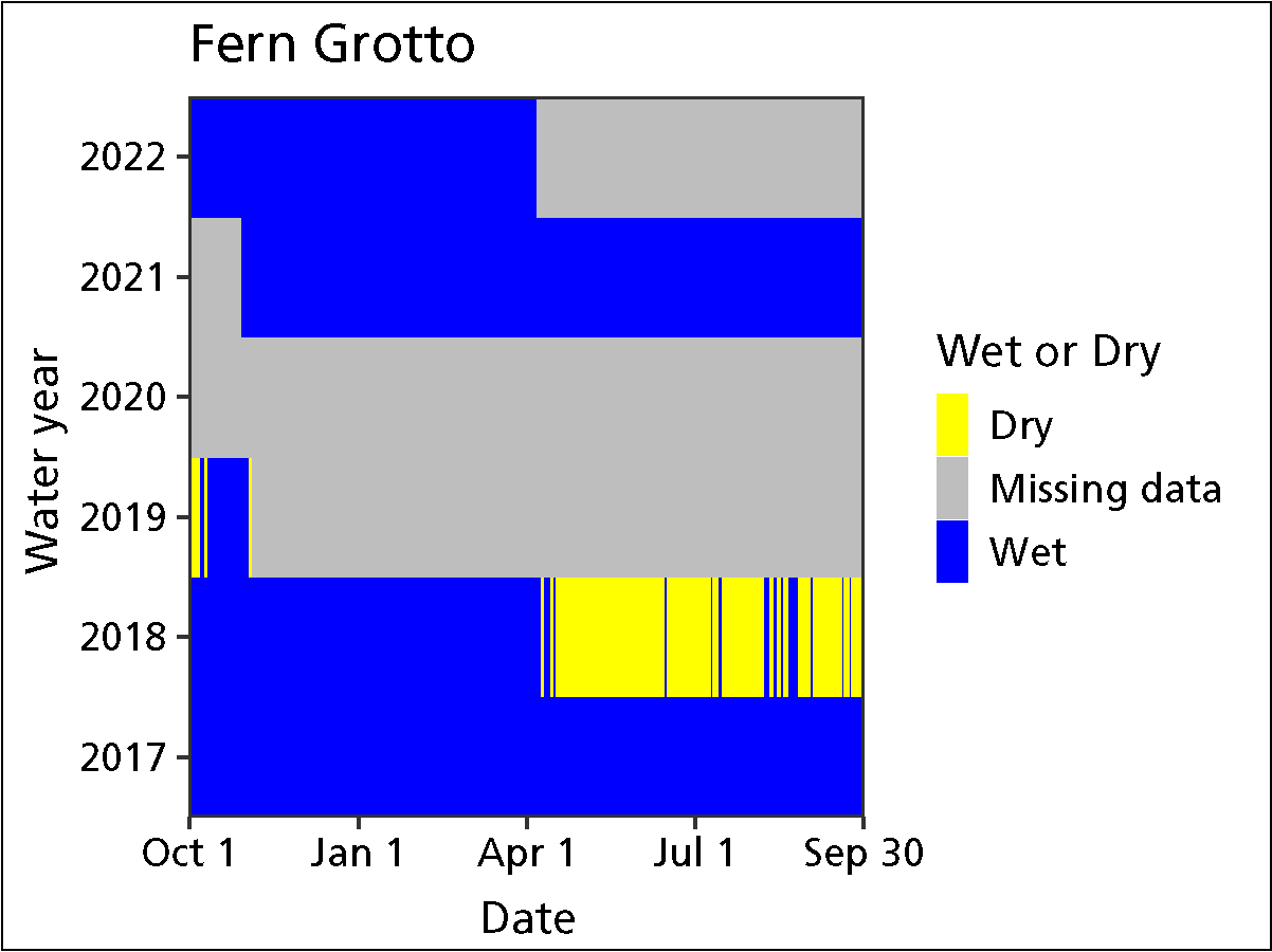
Figure 12. Water persistence in Fern Grotto, Coronado National Memorial.
Water quantity. When sampled on April 7, 2022, both orifices (the cave and marshy pool above) and the livestock trough contained surface water. Although the cave and trough were full, there was no surface outflow, so discharge and wetted extent measurements were not possible.
Temperature sensors indicated that Fern Grotto was “wetted” (contained water) for 189 of 189 days (100%) measured up to the WY2022 visit (Figure 12). In prior water years, the spring was wetted 58.4–100% of the days measured.
Water quality. Core water-quality and water-chemistry data were collected at the primary sampling location. Dissolved oxygen and chloride were slightly higher, and water temperature slightly lower, than observed in prior years (2017–2021). All other water-quality and chemistry values were within the range recorded in prior years (Tables 1 and 2). There was an issue with multi-probe calibration (daily post-calibration not done) that may have influenced our results for core water-quality parameters during this sampling period.
Table 1. Data on core water-quality parameters for Fern Grotto in water year 2022 and a range of values from prior years.
| Sampling location | Measurement location (width, depth) |
Parameter | WY2022 value (range of prior values) |
Prior years measured (# of measurements) |
|---|---|---|---|---|
| 002 | Center | Dissolved oxygen (mg/L) | 6.61 (4.69–5.41) | 2018–2021 (3) |
| 002 | Center | pH | 7.31 (6.92–7.45) | 2017–2021 (4) |
| 002 | Center | Specific conductivity (µS/cm) | 666 (639–678) | 2017–2021 (4) |
| 002 | Center | Temperature (°C) | 15.9 (17.2–18.6) | 2017–2021 (5) |
| 002 | Center | Total dissolved solids (mg/L) | 433 (415–442) | 2017–2021 (4) |
Table 2. Data on water-chemistry parameters (mg/L) for Fern Grotto in water year 2022 and a range of values from prior years.
| Sampling location | Measurement location (width, depth) |
Parameter | WY2022 value (range of prior values) |
Prior years measured (# of measurements) |
|---|---|---|---|---|
| 002 | Center | Alkalinity (CaCO3) | 270 (220–280) | 2017–2021 (4) |
| 002 | Center | Calcium (Ca) | 115 (82–120) | 2017–2021 (4) |
| 002 | Center | Chloride (Cl) | 23 (5–21) | 2017–2021 (4) |
| 002 | Center | Magnesium (Mg) | 11 (11–20) | 2017–2021 (4) |
| 002 | Center | Potassium (K) | 0.3 (0.1–0.6) | 2017–2021 (4) |
| 002 | Center | Sulphate (SO4) | 66 (45–66) | 2017–2021 (4) |
Sparkes Spring
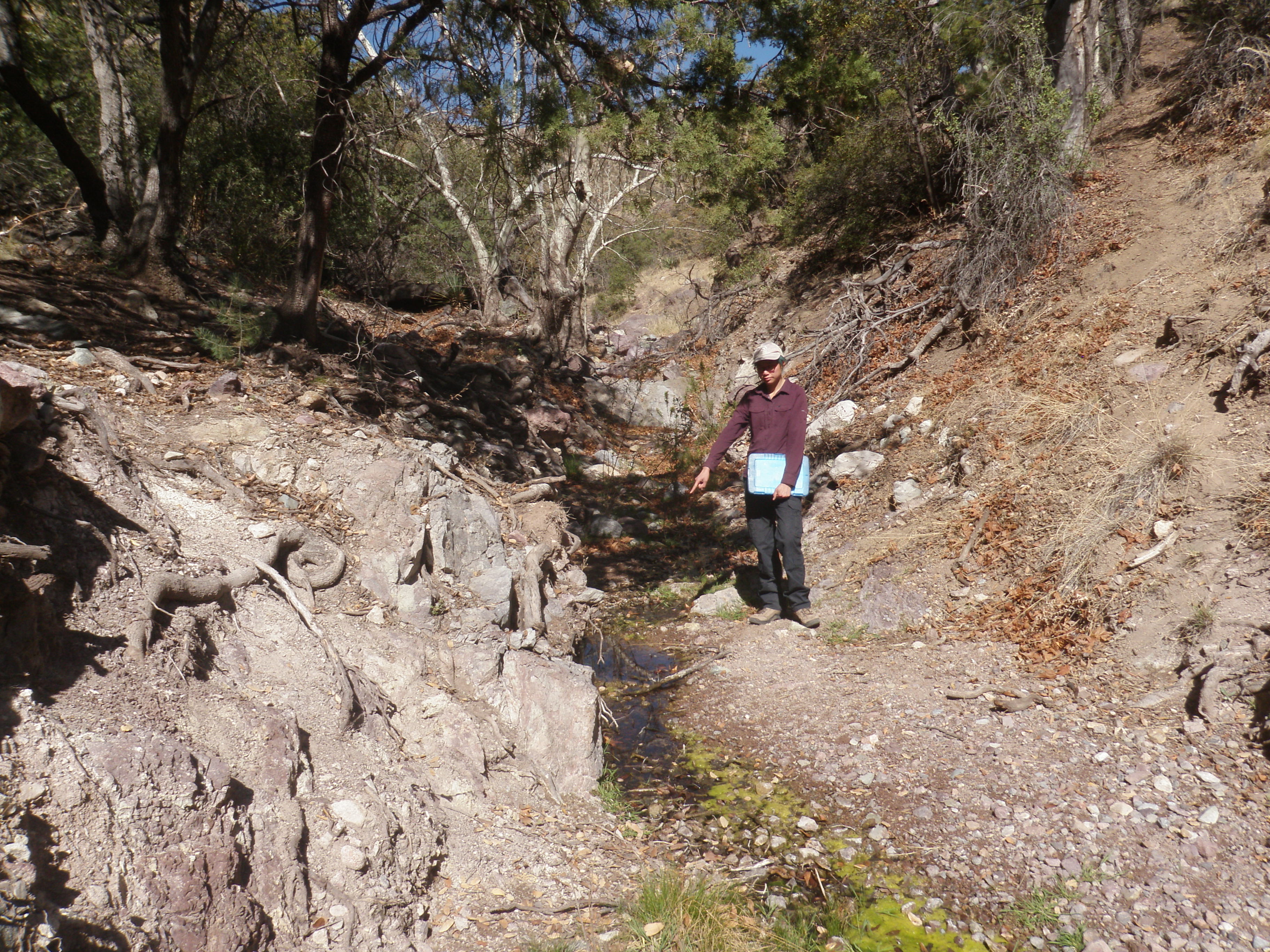
Figure 13. Sparkes Spring at Coronado National Memorial, April 2022. NPS photo.
Sparkes Spring (Figure 13) is a rheocrene spring (emerges as a flowing stream) that comprises a complex of pools. The pools start at the base of a large bedrock outcrop that straddles the channel of Montezuma Canyon. When visited on April 8, 2022, flow throughout ranged from subsurface to surface, with numerous small and medium (but shallow) pools and saturated soils. The channel was about three meters wide, fairly straight, with steep side slopes of soil, cobbles, and vegetation, and lined with small seep willows. The pools contained numerous aquatic and terrestrial insects.
Site condition. In WY2022, the crew noted more social trails, vegetation trampling, and discarded clothing and other trash than in past years. They rated impacts from social trails as “moderately disturbed” and from contemporary human use as “slightly disturbed.” As with Fern Grotto, Sparkes Spring appeared to be receiving more human use in WY2022 than since monitoring started in WY2017. Because the remnants of a dam within the springbrook influence flow, the crew rated the site as “slightly disturbed” due to flow modification, as in past years. Also consistent with past observations, extensive tracks and other sign of deer, javelina, and small mammals were evident throughout the site, making the spring “slightly disturbed” and highlighting its importance to park wildlife.
As in past years, the crew did not observe crayfish or bullfrogs (non-native invasive aquatic animals), nor did they observe any non-native plants. A number of obligate wetland plants that have been consistently detected at Sparkes Spring since monitoring started in WY2017 were also observed in 2022: the tree, Arizona sycamore (Platanus wrightii); the shrub, mule-fat (Baccharis salicifolia); and sedges in the Carex and Eleocharis genera.
Special project: eDNA inventory. Six water samples were collected and filtered (0.45-µm mesh) from six pools located throughout the springbrook at Sparkes Spring during the April visit. None of our target organisms (see Methods section) was detected. Additional data collection for this inventory is occurring at this site, to be discussed in a future, more detailed report.
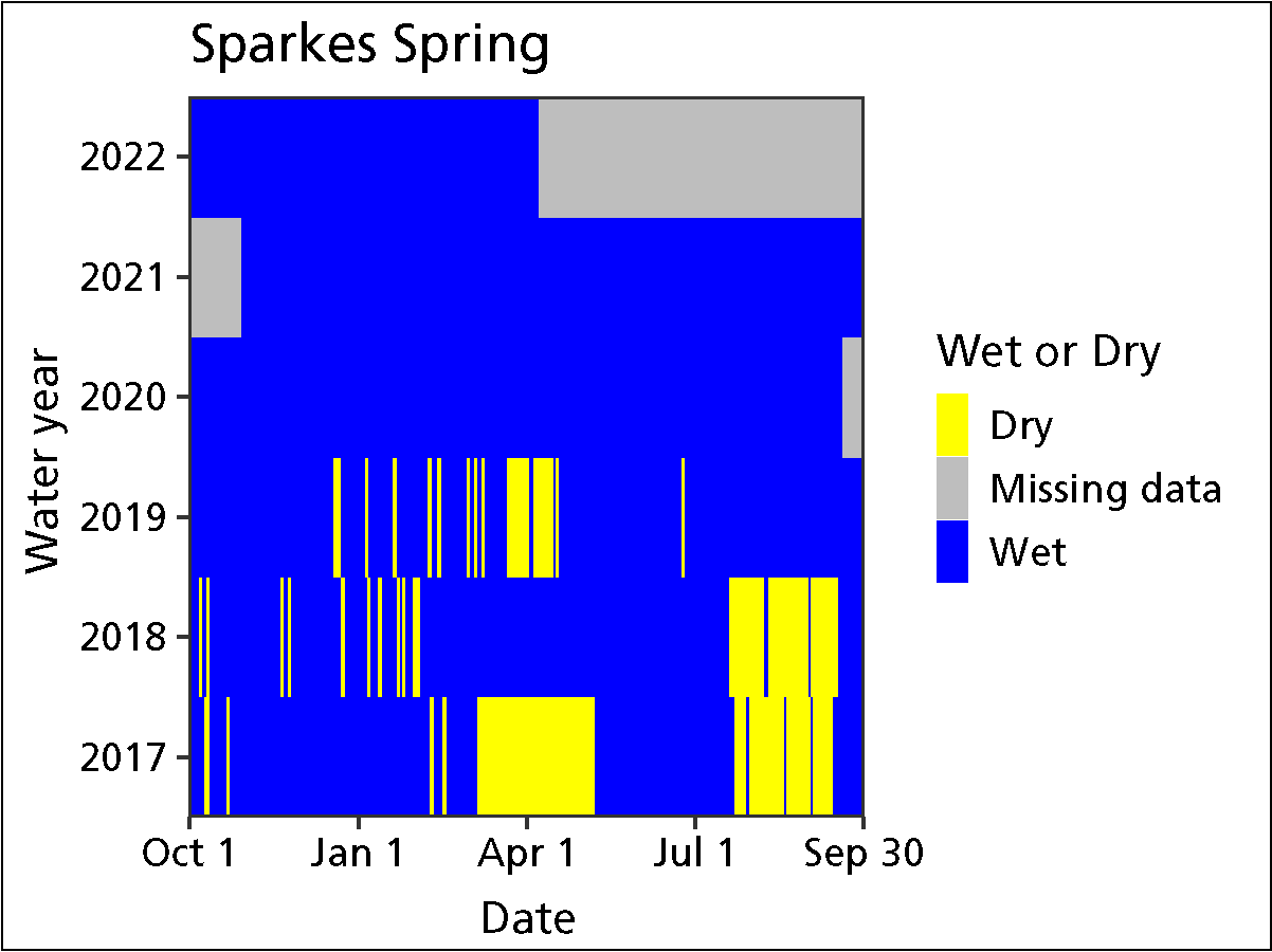
Figure 14. Water persistence in Sparkes Spring, Coronado National Memorial.
Water quantity. When sampled on April 8, 2022, and the spring was wetted. Discharge was estimated at 2.5 ± 0.1 liters per minute in WY2022—well below previous estimates of 4.3–11.5 liters per minute. Wetted extent was also reduced compared to that of previous years, with length (94 m), mean depth (1.6 cm), and mean width (46 cm) all less than values observed in WY2017–2021 (Table 3). Wetted extent was evaluated using a method for flowing water. Temperature sensors indicated that Sparkes Spring was “wetted” (contained water) for 190 of 190 days (100%) measured up to the WY2022 visit (Figure 14). In prior water years, the spring was wetted 66.8–100% of the days measured.
Water quality. Core water-quality and water-chemistry data were collected at the primary sampling location. As in past years, dissolved oxygen was surprisingly low (0.72 mg/L) at Sparkes Spring, perhaps due to the effect of stagnant water at the sampling location and the thick layer of decomposing leaves. Overall water-quality and water-chemistry values for 2022 (Tables 4–5) were generally within or relatively close to the range recorded in prior years, although sulfate (SO4) and chloride (Cl) were substantially higher, and calcium (Ca) lower, than values observed in previous years (Table 4).
Table 3. Average (± SD) width and depth (cm) of Sparkes Spring within springbrook length (up to 100m) in water year 2022 and a range of values from prior years.
| Measurement | WY2022 value (range of prior values) | Prior years measured (# of measurements) |
|---|---|---|
| Width (cm) | 46 ± 32.8 (64.7–99.4) | 2017–2021 (4) |
| Depth (cm) | 1.6 ± 0.6 (1.8–3.4) | 2017–2021 (4) |
| Length (m) | 94.5 (100) | 2017–2021 (4) |
Table 4. Data on core water-quality parameters for Sparkes Spring in water year 2022 and a range of values from prior years.
| Sampling location | Measurement location (width, depth) | Parameter | WY2022 value (range of prior values) |
Prior years measured (# of measurements) |
|---|---|---|---|---|
| 001 | Center | Dissolved oxygen (mg/L) | 0.72 (0.37–0.69) | 2018–2021 (3) |
| 001 | Center | pH | 6.89 (6.75–7.19) | 2017–2021 (4) |
| 001 | Center | Specific conductivity (µS/cm) | 765 (770–788) | 2017–2021 (4) |
| 001 | Center | Temperature (°C) | 17.1 (16.6–18.7) | 2017–2021 (5) |
| 001 | Center | Total dissolved solids (mg/L) | 497 (500.5–513.5) | 2017–2021 (4) |
Table 5. Data on water-chemistry parameters (mg/L) for Sparke Spring in water year 2022 and a range of values from prior years.
| Sampling location | Measurement location (width, depth) |
Parameter | WY2022 value (range of prior values) |
Prior years measured (# of measurements) |
|---|---|---|---|---|
| 001 | Center | Alkalinity (CaCO3) | 330 (300–350) | 2017–2021 (4) |
| 001 | Center | Calcium (Ca) | 32 (80–105) | 2017–2021 (4) |
| 001 | Center | Chloride (Cl) | 13 (0–9) | 2017–2021 (4) |
| 001 | Center | Magnesium (Mg) | 17 (22–43) | 2017–2021 (4) |
| 001 | Center | Potassium (K) | 1.6 (0.2–1.1) | 2017–2021 (4) |
| 001 | Center | Sulphate (SO4) | 83 (49–67) | 2017–2021 (4) |
Report Citation
Authors: Kara Raymond, Andy Hubbard, Cheryl McIntyre
Raymond, K., A. Hubbard, and C. McIntyre. 2023. Climate and Water Monitoring at Coronado National Memorial: Water Year 2022. Sonoran Desert Network, National Park Service, Tucson, Arizona.
Tags
- coronado national memorial
- climate
- groundwater
- springs
- monitoring
- weather
- arizona
- weather and climate
- sodn
- science
- american southwest
- science and resource management
- swscience
- water
- water in the desert
- water in the west
- water quality
- water quality monitoring
- sonoran desert network
- sonoran desert
- monitoring report
