Last updated: August 29, 2025
Article
Study of Macroinvertebrates Finds Emerging Resilience After Massive Coastal Breach
Seawater blasted through Duck Harbor Beach dunes on Cape Cod in January 2021 and became a periodic part of the coastal landscape. The landscape is adapting.
About this article

This article was originally published in the "Features" section of Park Science magazine, Volume 39, Number 2, Summer 2025 (August 29, 2025).
NPS
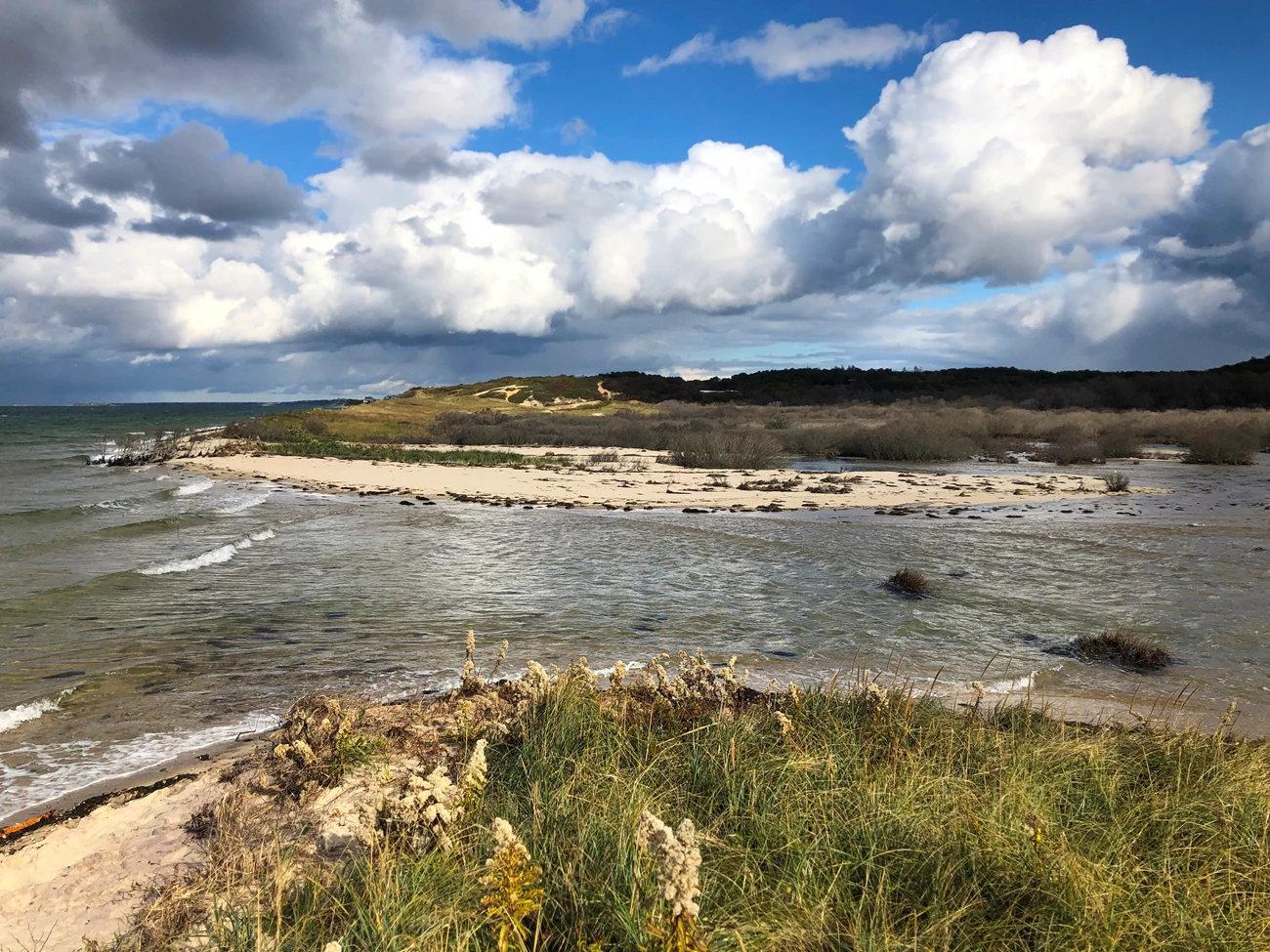
When you stand at the edge of the Duck Harbor parking lot in Cape Cod National Seashore, Wellfleet, Massachusetts, it may not be obvious why this quiet, sandy beach is called a “harbor.”
But historically, ships navigated the Duck Harbor basin when it was still connected to the tidal waters of Cape Cod Bay. Over time, natural sand movement along the outer Cape built up large dunes. By the mid-1900s, these dunes had blocked off the basin from the sea. The area eventually became a landscape of wetland shrubs and pitch pine forest, a scene familiar to locals, visitors, and scientists.
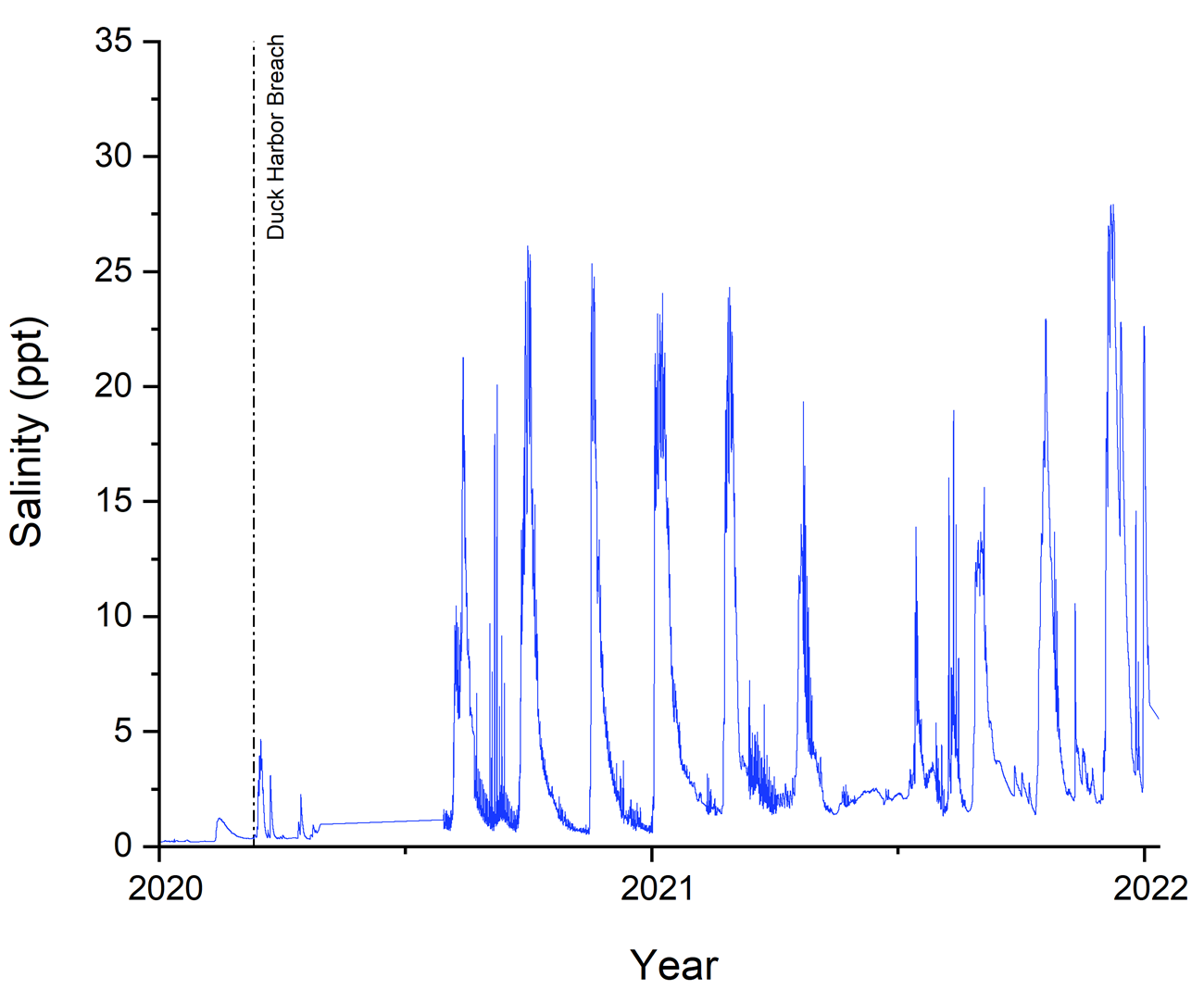
That landscape changed dramatically in January 2021. Astronomical high tides (those caused by the gravitational pull of the sun or moon) caused seawater to breach the barrier dunes at Duck Harbor Beach. It flowed into the basin and parts of the nearby Herring River. Underwater sensors detected a stark rise in salinity—the amount of dissolved salt in the water—more than a mile inland. In some places, the water became 54 times saltier. After the breach, twice-monthly spring tides, and other high tides, continued to introduce more salt water into the ecosystem.
Unlike typical overwash events driven by coastal storms, the breach at Duck Harbor is unique. “While coastal barriers are prone to erosion and change, the frequency and regularity of the overwashes at Duck Harbor are unprecedented on Cape Cod,” said Tim Smith, former restoration ecologist at Cape Cod National Seashore. He said it now only takes a normal astronomical high tide in non-storm conditions for water to enter the Herring River system. He said it gives scientists “a remarkable opportunity to study this living laboratory.”
“Macroinvertebrates are the glue that holds our coastal food webs together. They’re food to every fish you can find on a restaurant menu. No macroinvertebrates—no fish fry.”
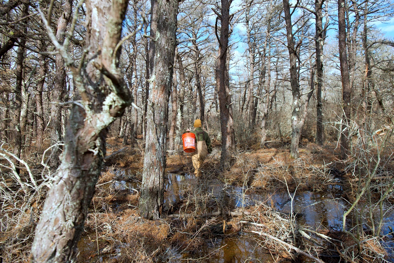
The saltwater influx visibly affected freshwater upland and wetland shrubs. Pitch pines browned from repeated salt exposure, while salt-tolerant plants began to grow, signaling a shift from forest to salt marsh in Duck Harbor. Freshwater macroinvertebrates (small aquatic insects and crustaceans) are also usually sensitive to salinity. But it was unclear how Duck Harbor’s local macroinvertebrate community would respond. That was important to know, because the Herring River’s macroinvertebrate community is deeply connected to the fish, birds, and wildlife that support Cape Cod’s fishing and tourism economy. As local marine ecologist Agnes Mittermayr explained, “Macroinvertebrates are the glue that holds our coastal food webs together. They’re food to every fish you can find on a restaurant menu. No macroinvertebrates—no fish fry.”
NPS / Bridget Ye
In response to the unusual overwash conditions, park scientists surveyed macroinvertebrates in the Herring River in 2023. Our internal results detected a decline in abundance and a change in the variety of species. Two freshwater species, a clam and isopod (a shrimp-like crustacean), disappeared entirely. Other species tolerant of higher salinity, such as non-biting midges, became more common. This shift toward salt-tolerant species could affect fish and other animals that rely on freshwater macroinvertebrates for food. But overall, the river appeared to be still in transition, supporting a productive macroinvertebrate community. Our results show the adaptability of an ecosystem that naturally changes over time.
It's the Little Things
“We often focus on the big things we can see,” said Sophia Fox, aquatic ecologist at Cape Cod National Seashore, “but it’s the tiny organisms that are the foundation. Because of their size, macroinvertebrates are sensitive to their environment and a good place to measure change.” Their sensitivity makes sampling them a key part of water-quality monitoring programs.
The EPA and other agencies use these tiny creatures to assess water contamination or other impairments. Monitoring programs look at factors like how many different species there are and whether pollution-sensitive organisms are present. These data, combined with water chemistry and sediment quality, help determine whether estuaries and tidal rivers are healthy or degraded.
NPS / Kaitlyn Button
Previous macroinvertebrate studies in the upper Herring River were done under stable freshwater conditions. In contrast, our study captured salinity changes in what was historically a freshwater waterway. It offers an early glimpse of how tidal exposure can reshape the river’s macroinvertebrate community. These findings also provide clues on how other tidal rivers may respond to saltwater intrusion from, for example, sea-level rise.
These findings also provide clues on how other tidal rivers may respond to saltwater intrusion from, for example, sea-level rise.
A Great Opportunity
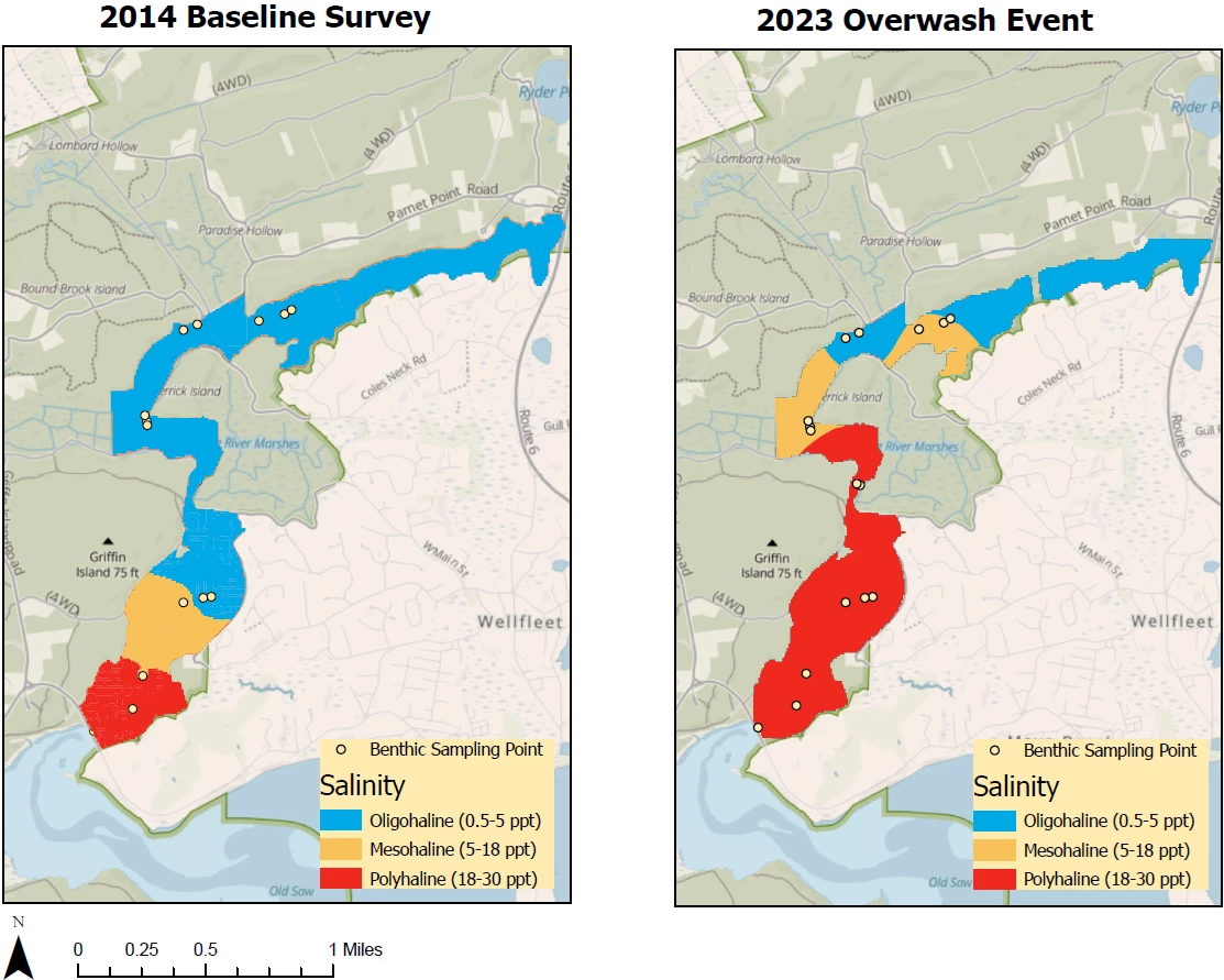
In August 2023, two years after the initial breach, park scientists sampled 15 locations across three different zones of the Herring River:
- a marine zone, where conditions are naturally salty
- an impact zone, where freshwater areas receive pulses of salt water from Duck Harbor
- an upper freshwater zone, unaffected by saltwater intrusion
NPS / Kaitlyn Button
Two brightly colored maps of Duck Harbor. The left map shows the 2014 baseline survey with salinity levels. The right side map is a map of the 2023 overwash event with resulting salinity levels.The legend on both maps lists benthic sampling points as a white dot with a black outline. Salinity is depicted with colors:
-
Blue represents oligohaline (0.5-5 parts per thousand)
-
Yellow represents mesohaline (5-18 ppt)
-
Red represents polyhaline (18-30 ppt)
In 2014
-
9 out of 15 sampling locations in the northern two-thirds of the map measured .5-5 ppt or oligohaline (blue).
-
The sampling locations extend northeast from the bottom of the map, around Griffin Island. Then they head straight north around the western edge of Derrick Island. There are four sampling locations on the west edge and four on the north edge of the island.
-
All locations near the island and the river marshes to the southeast of the island are registered as oligohaline or blue.
-
The bottom third of the map shows three sampling locations. All three are south to slightly southwest of Griffin Island and the inlet from the Ocean.
-
There is one sampling location in the top half of the southern third of the map. It registered as 5-18 ppt or mesohaline (yellow).
-
The second half of the southern third registered as 18-30 ppt or polyhaline (red).
In 2023
-
After the 2023 overwash event, six of the southernmost sampling locations registered as polyhaline (red).
-
The southernmost half of the sampling locations registered as polyhaline (red).
-
Six of the 15 sampling locations registered as polyhaline (red).
Of the remaining northern sampling locations in the north around the side of Derrick Island, four are yellow and three are blue.
At each site, we recorded water temperature, salinity, clarity, dissolved oxygen, and pH. We then collected benthic (bottom-dwelling) macroinvertebrates. We used a ponar grab sampler, a device like a big, heavy, metal clamshell. Lowered into the water on a cable, the “shell” stays open until it hits the bottom. Then it clamps shut and scoops up sediment and benthic organisms from the riverbed.
The 15 sites sampled in 2023 had also been surveyed in 2014 and 2015. This made it possible to compare changes in macroinvertebrate communities over time.
The 15 sites sampled in 2023 had also been surveyed in 2014 and 2015. This made it possible to compare changes in macroinvertebrate communities over time. The older data were particularly useful during overwash events. “A lot of time we’re measuring things after events have happened,” Fox said, “and we don’t have baseline to compare to...this was a great opportunity to examine change.”
NPS / Kaitlyn Button
(Really) Hot Temperatures and Lots of Sifting
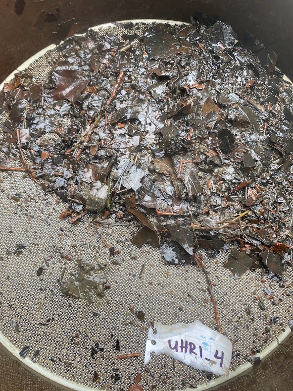
After field sampling, we brought the benthic samples back to the lab. We sifted each of them through a sieve with holes one millimeter in size, about as small as a single sugar crystal. This uncovered the macroinvertebrates. We then preserved them for later identification, storing them in glass jars filled with ethanol and a pink dye called rose bengal. The dye makes the organisms easier to see under a microscope. We carefully examined each organism under a dissecting scope to identify it to its smallest taxonomical group; e.g., genus or species.
To better understand the habitat where we found these organisms, we also analyzed the sediment from the ponar grabs. We did two tests: “loss on ignition” and particle size. These tests helped us describe the habitat conditions that supported the different macroinvertebrate communities we found.
Loss on ignition test: how much organic matter, like plant or animal parts, is in the sediment?
We weighed the sediment sample, then heated it in a furnace to an extremely high temperature, up to 1022 °F. That’s about as hot as lava from a volcano. After the sample cooled, we weighed it again. The difference in weight before and after heating told us how much burnable material (organic matter) was in the sediment. We used the percentage of organic matter in each zone to see whether habitat differences could explain variations in the macroinvertebrate community across the three zones.
NPS / Kaitlyn Button
Particle size analysis: what kind of sediment is it, fine gravel, sand, silt, or other?
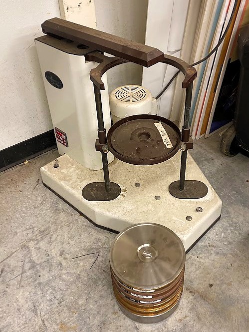
We took 17 grams of sediment and placed it in a motorized stack of sieves. This device looks like several plates with screens stacked on top of each other. The top screen has the largest openings to catch coarse material, while the bottom screen has the smallest openings to catch the finest sediment. When the stack is shaken, the sediment moves downward, with each layer holding particles of a specific size. We then weighed the sediment from each sieve to calculate the percentage of fine gravel (the largest particles), sand, and silt (the smallest particles) at each site. Like for organic matter, knowing the proportions of gravel, sand, and silt helped us determine if sediment type explained macroinvertebrate community variations.
Evolving Conditions
We found an average of 1,800 organisms per square meter, about 167 per square foot, in our samples. That’s a 67 percent decrease from the 5,500 per square meter that researchers found in 2015. We also saw the number of different species drop from 6.6 species per sample in 2015 to about 4.1 species per sample, a 38 percent decrease. The difference in number of species per sample between 2014 and 2023 was smaller (5.6 species). The sediment substrate was mostly sand (79 to 92 percent). The amount of organic matter increased the further upstream we sampled. This was expected because of slower water movement and less tidal flushing in the upstream sites than those closer to the mouth of the river.
The significant decline in density and diversity of macroinvertebrates since 2015 points to new ecological conditions resulting from the tidal breach.
In contrast to the declines found when comparing data across the years, we didn’t find any significant differences in numbers per sample, or numbers of different species within a single year, across the three river zones—marine, impact, and freshwater. The significant decline in density and diversity of macroinvertebrates since 2015 points to new ecological conditions resulting from the tidal breach, such as higher salinity that favors some species over others. To better understand how macroinvertebrate communities were changing, we looked more closely at the specific types of organisms present in each zone.
A Natural Adjustment
We hypothesized that saltwater intrusion after the Duck Harbor breach would significantly affect benthic macroinvertebrates in the impact zone. But we thought the freshwater zone would remain similar to what it was in the baseline study. Our results showed that changes in macroinvertebrate populations from the baseline years of 2014–2015 to 2023 were mainly driven by the loss of two dominant freshwater species. These were a freshwater sow bug and a freshwater fingernail clam. But the potential effect of saltwater intrusion on these species varied between the impact and upper freshwater zones.
In the Duck Harbor impact zone, both the freshwater sow bug and fingernail clam were present in 2014 and 2015 but completely absent in 2023. Other species became more common during that time. Saltwater-tolerant, non-biting midges, for example, increased by 12 percent from 2014 to 2023.

NPS / Sophia Fox
Although we predicted that the freshwater zone would remain stable, the sow bug declined by approximately 94 percent, and the fingernail clam declined by about 71 percent. Unlike the impact zone, there was no increase in non-biting midges. The freshwater zone experienced little direct saltwater intrusion in comparison to the impact zone. This indicated that even small increases in salinity may have contributed to those changes. Or other environmental factors, like nutrients or metals displaced from soils by seawater, may have caused them.
In such a dynamic system, this ongoing change reflects a natural adjustment to evolving conditions rather than a permanent loss.
We expected, and found, changes in the river’s macroinvertebrate community comparable to those in the plant community. But our data show that the overall system remained resilient. Landscape changes opened new niches, allowing different species to move in. “None of the seashore systems are static,” noted Fox. “Everything is always changing.” In such a dynamic system, this ongoing change reflects a natural adjustment to evolving conditions rather than a permanent loss. The Herring River ecosystem appears to be doing fine.
Up Next
Smith said the exposure of old tidal channels and ditches created an opportunity “to document the site’s hydrology and how it influences the dynamic habitat changes currently unfolding.” Although salinity is likely a key reason for the changes we saw, it may not be the only driver. Increased nutrients like ammonium or iron oxides may also play a role, one we could study through in-stream water quality measurements or controlled lab experiments. These nutrients can change oxygen levels in the sediment and water, creating conditions only certain macroinvertebrates can tolerate.
As salinization of the Herring River continues, marine species may begin to colonize areas where freshwater species are in decline.
As salinization of the Herring River continues, marine species may begin to colonize areas where freshwater species are in decline. This recruitment could help maintain essential ecological functions like nutrient cycling, even as species composition shifts. Fox noted that it will be particularly interesting to see how the Herring River changes when it receives new organisms from the Duck Harbor overwashes. A great question for future research—and something to think about at the next fish fry.
About the author
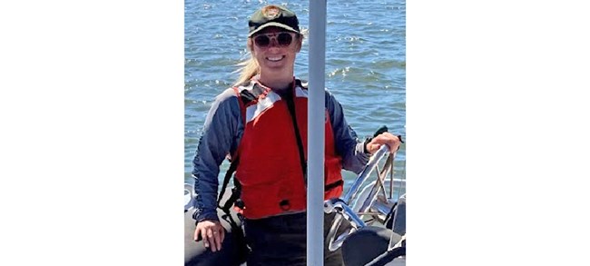
Kaitlyn Button is a biological science technician with the National Park Service, Northeast Coastal and Barrier Network. Prior to that, she worked as a biological science technician at Cape Cod National Seashore, monitoring coastal aquatic resources. In 2024, she completed her final master’s degree project on the impact of saltwater intrusion on freshwater macroinvertebrates in the Herring River, Wellfleet, MA. NPS photo.Cite this article
Button, Kaitlyn. 2025. “Study of Macroinvertebrates Finds Emerging Resilience After Massive Coastal Breach.” Park Science 39 (2). https://www.nps.gov/articles/000/psv39n2_study-of-macroinvertebrates-finds-emerging-resilience-after-massive-coastal-breach.htm
