Last updated: March 11, 2022
Contact Us
Article
Nauvoo Exhibits Audio Description

NPS Exhibit
A Long Journey Exhibit Audio Description
-
Nauvoo National Historic Landmark - A Long Journey Exhibit Audio Description
Listen to the audio description Nauvoo National Historic Landmark - A Long Journey exhibit.
- Credit / Author:
- NPS
001 (Grade 6) Upright Wayside Panel: A Long Journey 905 words / Panel Description: 7.25 minutesIn front of you, is an upright exhibit panel it is 3 feet wide and 4 feet tall, and about 3 feet off the ground. Behind you, is Parley Street. In front of you, is a flat grassy park with scattered deciduous trees. Directly behind the panel and along the edge of the park, is a wood fence with posts about every 4 feet, 3 horizontal wood rails run between the posts. To the left of this panel, there is an opening in the fence, about 4 feet wide. Go through this opening to get to the park. On the other side of the opening, on the left is another exhibit panel. On the park side of the fence, about 150 feet, to your left and toward the river, is a life-sized replica of a ferry with a covered wagon. The river is about 80 feet, or 25 meters, past the ferry.
There is a black banner across the top on the panel. Left side text reads Nauvoo, Illinois. Right side of the panel has the white, orange, and black triangular logo for the Mormon Pioneer National Historic Trail.
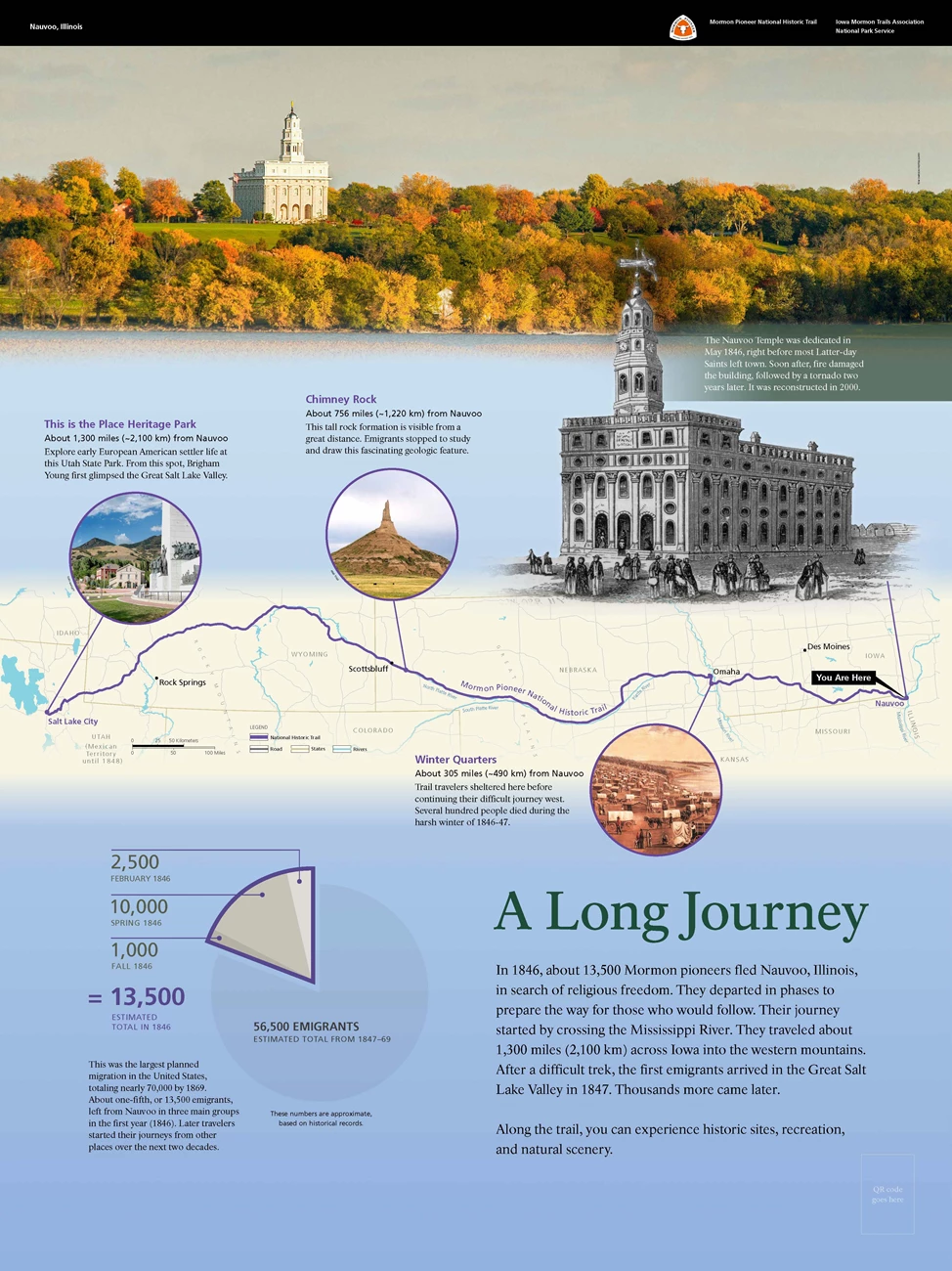
Title: A Long Journey Primary text is in the lower right-hand corner: Primary Text reads: A Long Journey In 1846, about 13,500 Mormon pioneers fled Nauvoo, Illinois, in search of religious freedom. They departed in phases to prepare the way for those who would follow. Their journey started by crossing the Mississippi River. They traveled about 1,300 miles, or 2,100 kilometers across Iowa into the western mountains. After a difficult trek, the first emigrants arrived in the Great Salt Lake Valley in 1847. Thousands more came later. Along the trail, you can experience historic sites, recreation, and natural scenery. End of Text
To the left of the text, is a circular pie chart. One-fifth of the chart is outlined in purple. This section represents the estimated 13,500 Mormon pioneers who left Nauvoo in 1846. This section is subdivided into 3 smaller parts in different shades of gray. About 2,500 Mormon pioneers left in February 1846, followed by about 10,000 more in Spring 1846, and 1,000 more in the Fall of 1846. The remaining four-fifths represents the 56,500 emigrants who left Nauvoo between 1847 and 1869. These numbers are approximate, based on historic records.
Text below pie chart reads:
This was the largest planned migration in the United States, totaling nearly 70,000 by 1869. About one-fifth, or 13,500 emigrants, left from Nauvoo that first year (1846). Later travelers started their journeys from other places over the next 2 decades. End of Text
Across the middle of the panel, is a modern map of the central part of the United States. The states are off-white and outlined in tan. Roads are shown in gray and rivers are in blue. The Mormon Pioneer National Historic Trail is shown as a curving purple line from Nauvoo, Illinois, at the east end, to Salt Lake City, Utah, at the west end, crossing Iowa, Nebraska, and Wyoming in between. Utah was part of Mexican Territory until 1848. Other cities along the trail are identified with black dots and black text. 3 sites are highlighted with pictures and text.
On the map Near Omaha, Nebraska, is a circle framing a color painting. The painting displays The Winter Quarters, a scene of a riverbank that is densely filled with people and covered wagons. Text to the right of framed painting: Winter Quarters, About 305 miles, or 490 kilometers, from Nauvoo. Trail travelers sheltered here before continuing their difficult journey west. Several hundred people died during the harsh winter of 1846 to 1847.
On the map near Scottsbluff, Nebraska, is another circle framing a color photograph. It shows a large brown rock formation, a small mountain, with a pointed tip. Text reads, Chimney Rock, about 756 miles, or 1,220 kilometers, west of Nauvoo. This tall rock formation is visible from a great distance. Mormon pioneers stopped to study and draw this fascinating geologic feature.
On the map At Salt Lake City, Utah, a third circle frames a color photograph of This is the Place Heritage Park. It shows a tall white stone monument surrounded by bronze sculptures of people. In the background, are buildings and mountains. Text reads: This is the Place Heritage Park it is about 1,300 miles, or 2,100 kilometers, west of Nauvoo. Explore early European American settler life at this Utah State Park. From this spot, Brigham Young first glimpsed the Great Salt Lake Valley. End of Text
Above the map, on the right, is a grayscale drawing of the Nauvoo Temple, a tall ornate building with arched window openings and a tall cupola. Groups of people are standing and walking in front of it. Text above drawing: The Nauvoo Temple was dedicated in May 1846, right before the Latter-day Saints left town. Soon after, fire damaged the building, followed by a tornado 2 years later. It was reconstructed in 2000.
Across the top of the panel, is a color photograph of a sloping landscape and a river. The riverbank is filled with yellow and orange deciduous trees. On the top of the hill, is the reconstructed Nauvoo Temple. It is a rectangular white building with a tall, domed cupola. In the bottom right corner of the panel, is a QR code that you can scan with a mobile device to explore more about this wayside, including audio description. [End of Message]

NPS Exhibit
Into the Unknown Exhibit Audio Description
-
Nauvoo National Historic Landmark - Into the Unknown Exhibit Audio Description
Listen to the audio description Nauvoo National Historic Landmark - Into the Unknown exhibit.
- Credit / Author:
- NPS
002 (Grade 6) Slanted Wayside Panel: Into the Unknown 505 words / Panel Description: 3.5 minutesIn front of you, is a slanted panel 3 feet wide by 2 feet tall, and about 3 feet off the ground, on your left, is Parley Street. On your right, is a flat grassy park with scattered deciduous trees. Perpendicular to the panel, is a wood fence with posts about every 4 feet, 3 horizontal wood rails run between the posts. Immediately to your right, there is an opening in the fence, about 4 feet wide. Go through this opening to get to the park. On the other side of the opening there is another exhibit panel. About 150 feet, or 50 meters, ahead of you, is a life-sized replica of a ferry with a covered wagon. The river is about 80 feet, or 25 meters, past the ferry.
There is a black banner across the top on the panel. Left side text reads Nauvoo, Illinois. Right side of the panel has the white, orange, and black triangular logo for the Mormon Pioneer National Historic Trail.
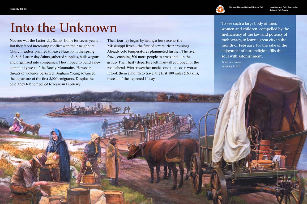
Title: Into the Unknown. Main Text: Nauvoo was the Latter-day Saints’ home for 7 years. But they faced increasing conflict with their neighbors. Church leaders planned to leave Nauvoo in the spring of 1846. Latter-day Saints gathered supplies, built wagons, and organized into companies. They hoped to build a new community west of the Rocky Mountains. However, threats of violence persisted. Brigham Young advanced the departure of the first 2,000 emigrants. Despite the cold, they felt compelled to leave in February.
Their journey began by taking a ferry across the Mississippi River—the first of several river crossings. Already cold temperatures plummeted further. The river froze, enabling 500 more people to cross and join the group. Their hasty departure left many ill equipped for the road ahead. Winter weather made conditions even worse. It took them a month to travel the first 100 miles, or 160 kilometers, instead of the expected 10 days.
End of Text
In the top right corner, is a quotation from the February 1, 1846, issue of Times and Seasons, a Latter-day Saint newspaper. Text reads: To see such a large body of men, women and children, compelled by the inefficiency of the law, and potency of mobocracy, to leave a great city in the month of February, for the sake of the enjoyment of pure religion, fills the soul with astonishment… End of Text
A colorful illustration fills the rest of the panel. The bottom half of the illustration shows a riverbank with patches of brown, yellow, and green grass and some snow. The treelined riverbank stretches across the middle of the illustration. In the foreground, several pioneers are shown packing supplies into and around a covered wagon pulled by yoked oxen. In the middle of the illustration, two ferries are shown crossing filled with people, covered wagons, supplies, and livestock.
In the bottom right corner of the panel, is a QR code that you can scan with a mobile device to explore more about this wayside, including audio description.
[End of Message]

