Last updated: March 11, 2022
Contact Us
Article
Mount Pisgah Exhibits Audio Descriptions

NPS Exhibit
Mormon Pioneer National Historic Trail Exhibit Audio Description
-
Mount Pisgah - Mormon Pioneer National Historic Trail Exhibit Audio Description
Listen to the audio description Mount Pisgah - Mormon Pioneer National Historic exhibit.
- Credit / Author:
- NPS
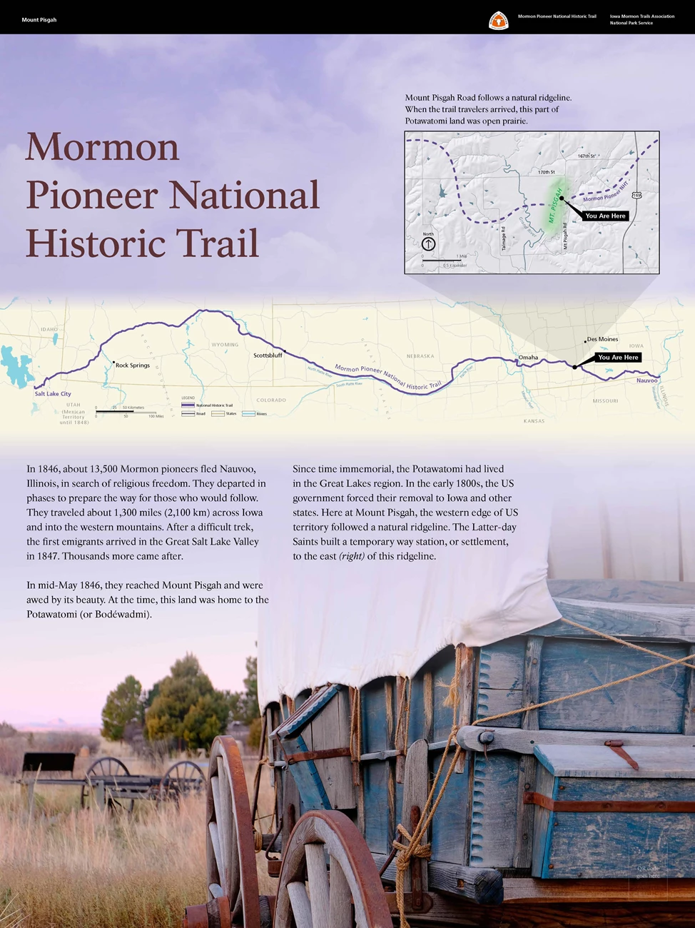
008 (Grade 5) Upright Wayside Panel: Mormon Pioneer National Historic Trail 649 words / Panel Description: 4.7 minutesIn front of you, is an upright panel 3 feet wide by 4 feet tall, about 3 feet off the ground. You are at the edge of a crushed rock parking lot next to a narrow grassy lawn, about 40 feet wide and 180 feet long. To your left, is a gravel road that loops around this lawn. To your right, is a tall deciduous tree. Behind you, is a one-story brick restroom building. Cross the road to your left to reach another panel and the Mount Pisgah Cemetery, which is on a steep hill. There are tall deciduous trees along the far side of the road.
There is a black banner across the top on the panel. Left side text reads Mount Pisgah. Right side of the panel has the white, orange, and black triangular logo for the Mormon Pioneer National Historic Trail.
Below the banner, is dark red text on a light blue and purple background: Title: Mormon Pioneer National Historic Trail
Across the middle of the panel, is black text on a light purple background:
Main text: In 1846, about 13,500 Mormon pioneers fled Nauvoo, Illinois, in search of religious freedom. They departed in phases to prepare the way for those who would follow. They traveled about 1,300 miles, or 2,100 kilometers, across Iowa and into the western mountains. After a difficult trek, the first emigrants arrived in the Great Salt Lake Valley in 1847. Thousands more came after.
In mid-May 1846, they reached Mount Pisgah and were awed by its beauty. At the time, this land was home to the Potawatomi, or Bodéwadmi.
Since time immemorial, the Potawatomi had lived in the Great Lakes region. In the early 1800s, the US government forced their removal to Iowa and other states. Here at Mount Pisgah, the western edge of US territory followed a natural ridgeline. The Later-day Saints built a temporary way station, or settlement, to the east, or right, of this ridgeline.
End of Text
Above the text, spanning across the panel, is a modern map of the middle part of the United States. North is up. The states are off-white and outlined with tan. The roads are shown in gray and rivers are in blue. The Mormon Pioneer National Historic Trail is shown as a curving purple line from Nauvoo, Illinois, at the east end, to Salt Lake City, Utah, in the west end, crossing Iowa, Nebraska, and Wyoming in between. Utah was part of the Mexican Territory until 1848. Other cities along the trail are identified with black dots and black text. You are at Mount Pisgah, which is south of Des Moines, Iowa, and is marked by a black flag with “You Are Here” in white text.
There is a smaller rectangular map in the top right corner of the panel that zooms into your current location at Mount Pisgah. North is up. The background is light gray with dark gray lines for roads and meandering blue lines for rivers. The Mormon Pioneer National Historic Trail is shown as a curving dashed purple line across the map from right to left. An area for Mount Pisgah is shaded light green and marked by a black flag with “You Are Here” in white text.
Across the bottom of the panel, is a color photograph of the bottom two-thirds of a covered wagon in a field. The wagon is made of weathered wood painted blue, with brown spoked wheels and an off-white canvas cover. Brown grasses fill the landscape. In the background, is a wooden wagon frame with spoked wheels. In the distance, are tall green leafy trees. Light purple and blue sky with white clouds fill the background of the panel.
In the bottom right corner of the panel, is a QR code that you can scan with a mobile device to explore more about this wayside, including audio description.
[End of Message]

NPS Exhibit
On the Brink Exhibit Audio Description
-
Mount Pisgah - On the Brink Exhibit Audio Description
Listen to the audio description Mount Pisgah - On the Brink Exhibit Audio Description exhibit.
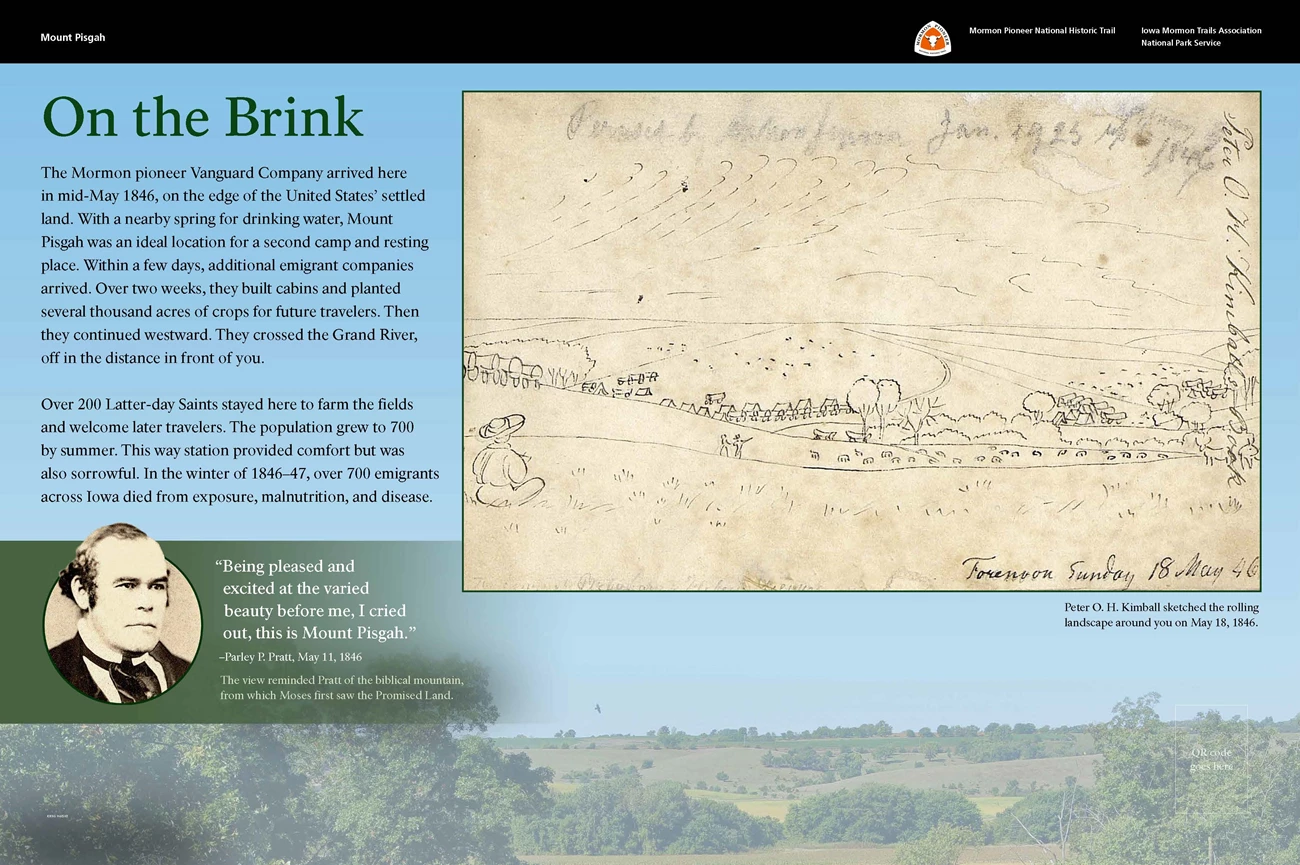
009 (Grade 5) Slanted Wayside Panel: On the Brink 593 words / Panel Description: 4.5 minutesIn front of you, is a slanted panel 3 feet wide by 2 feet tall, and about 3 feet off the ground. You are on a short concrete sidewalk that extends about 23 feet, or 7 meters, to your right. Near the middle of the sidewalk, there is a second angled sidewalk that extends ahead and to your right. The ground slopes slightly downward ahead of you. Follow the sidewalk to pass through a short, wrought iron fence. Continue about 100 feet, or 30 meters, to reach the Mount Pisgah Monument. Around you, are scattered deciduous trees. The ground slopes down into a valley with more scattered deciduous trees. Behind you, is a gravel road. On the other side of the road, is a 1-story brick restroom building.
There is a black banner across the top on the panel. Left side text reads Mount Pisgah. Right side of the panel has the white, orange, and black triangular logo for the Mormon Pioneer National Historic Trail.
Below the banner, on the left side of the panel, is green and black text on a bright blue background:
Title: On the Brink. Main text: The Mormon pioneer Vanguard Company arrived here in mid-May 1846, on the edge of the United States’ settled land. With a nearby spring for drinking water, Mount Pisgah was an ideal location for a second camp and resting place. Within a few days, additional emigrant companies arrived. Over 2 weeks, they built cabins and planted several thousand acres of crops for future travelers. Then they continued westward. They crossed the Grand River, off in the distance in front of you.
Over 200 Latter-day Saints stayed here to farm the fields and welcome later travelers. The population grew to 700 by summer. This way station provided comfort but was also sorrowful. In the winter of 1846 to 1847, over 700 emigrants across Iowa died from exposure, malnutrition, and disease.
End of Text
Below the text, is a quotation:
“Being pleased and excited at the varied beauty before me, I cried out, this is Mount Pisgah.” –Parley P. Pratt, May 11, 1846
The view reminded Pratt of the biblical mountain, from which Moses first saw the Promised Land.
End of Text
To the left of the quotation, is a historical photograph of Parley Pratt, a man with a receding hairline and bushy hair around his right ear. He wears a dark suit with a white shirt and a dark tie. His mouth is a straight line.
To the right of the main text, is a scanned copy of a sketch of large landscape. The sketch, in dark ink, shows a rolling hill across the foreground with a flat valley stretching out behind it. Near the bottom left corner, is a seated man with a wide-brimmed hat, looking out at the landscape. Along the rolling hills, are 2 people and a scattered group of animals. There are small tents, covered wagons, and scattered trees in the valley. In the bottom right, in cursive handwriting text reads: Forenoon Sunday 18 May ‘46. Along the right side of the sketch, is the artist’s signature.
Text below sketch: Peter O. H. Kimball sketched the rolling landscape around you on May 18, 1846. End of Text
Across the bottom, is a color photograph of rolling green and light brown hills, with scattered clusters of leafy green trees.
In the bottom right corner of the panel, is a QR code that you can scan with a mobile device to explore more about this wayside, including audio description.
[End of Message]

