Article

Lake Superior Geology

Leafless autumn image of a forested, gray rocky bluff in the background with a wooden fence running across the foreground.
The Greenstone Flow: One of Earth's largest lava flows creates a prominent bluff on the Keweenaw.

NPS photo

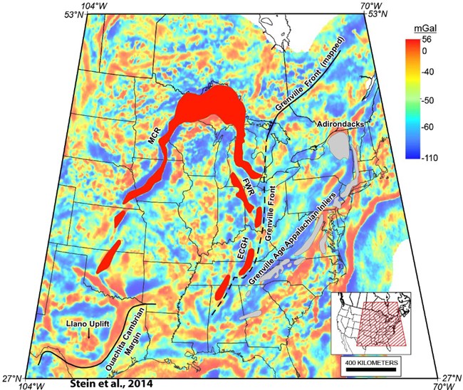
A map of most of the middle and Eastern United States featuring a colorful gradient from blue to red. Red indicates denser rock. A prominent red arch stretches from Oklahoma through Lake Superior and down to Alabama.
Gravity anomaly map highlighting the Midcontinent Rift. Areas in red indicate denser rock.

Stein, C. A., S. Stein, M. Merino, G. Randy Keller, L. M. Flesch, and D. M. Jurdy (2014), Was the Mid-Continent Rift part of a successful seafloor-spreading episode?, Geophys. Res. Lett., 41(5), 1465-1470, doi:10.1002/2013GL059176, 2014.

The copper of the Great Lakes formed during a spectacular period in Earth's history—at a time when the North American continent was splitting apart. This separation began about 1.1 billion years ago and at its peak had a length of over 3,000 kilometers. During this time, huge amounts of lava poured out of the earth's crust, forming sequences thousands of feet thick. In the present day, these relatively dense, massive flood basalts are only exposed in the Lake Superior region.

Midcontinent Rift Formation
Detailed Geologic Timeline
Isle Royale Geology and Soils

Lake Superior Cross-sectional Timeline

A relief map of the top half of the western Upper Peninsula and Isle Royale. A copper-colored band highlights where copper deposits could be found. A dark red line cuts across Canada, Isle Royale and the Keweenaw from northwest to southeast.

NPS image

The following slides feature a cross-sectional diagram along this line.
Cross sectional illustration showing rock types. Volcanic and sedimentary rocks form a bowl shape, with Isle Royale and the Keweenaw being opposite rims of the bowl. Blue outlines the bottom part of the bowl.
Long before Lake Superior formed (1.06-1.04 billion years ago), deep underground in the hot and highly pressurized basalt, water stripped minerals as it moved about.
Cross sectional illustration showing rock types. Volcanic and sedimentary rocks form a bowl shape, with Isle Royale and the Keweenaw being opposite rims. Blue outlines the bottom part of the bowl. Blue arrows point towards the rims of the bowl.
As the superheated water made its way toward the surface, both pressure and temperature decreased.
Cross sectional illustration showing rock types. Volcanic and sedimentary rocks form a bowl shape, with Isle Royale and the Keweenaw being opposite rims. Copper colored oval near the Isle Royale rim and copper colored circle on the Keweenaw rim.
This decrease in pressure and temperature allowed for the precipitation of minerals in the cracks and voids of the volcanic layers resulting in the largest native copper deposit ever discovered.
Cross sectional illustration showing rock types. Volcanic and sedimentary rocks form a bowl shape, with Isle Royale and the Keweenaw being opposite rims. A light blue band on the top signifies ice ~2 miles thick during the last glacial episode.

A large, piece of mass copper with a blue-green patina next to a green sign with the title: "Float Copper" make up the foreground. A stone building and wooden structure are in the background with green leaved trees completing the landscape.
Float copper on display in Calumet, MI

NPS photo

Glaciers played an important role in shaping the Lake Superior basin. Their slow, yet powerful, movement sheared copper from the host rock and transported it far away, sometimes hundreds of miles. These transported pieces are called float copper.
[2:42 PM] Clark, Nicholas J Cross sectional illustration showing rock types. Volcanic and sedimentary rocks form a bowl shape, with Isle Royale and the Keweenaw being opposite rims of the bowl. A thin sky-blue band fills the top of the bowl.
Melting ice filled the basin that would become Lake Superior.

Part of a series of articles titled Copper Connections.

Isle Royale National Park, Keweenaw National Historical Park

Last updated: March 6, 2024