Last updated: May 6, 2025
Contact Us
Article
Gardner Junction Exhibits Audio Description
NPS Exhibit
Eye of Needle Exhibit Audio Description
-
Gardner Junction - Eye of the Needle Exhibit Audio Description
Wayside interpretive exhibit, full audio description is available.
- Credit / Author:
- NPS
- Date created:
- 05/06/2025
Eye of the Needle. 708 words.
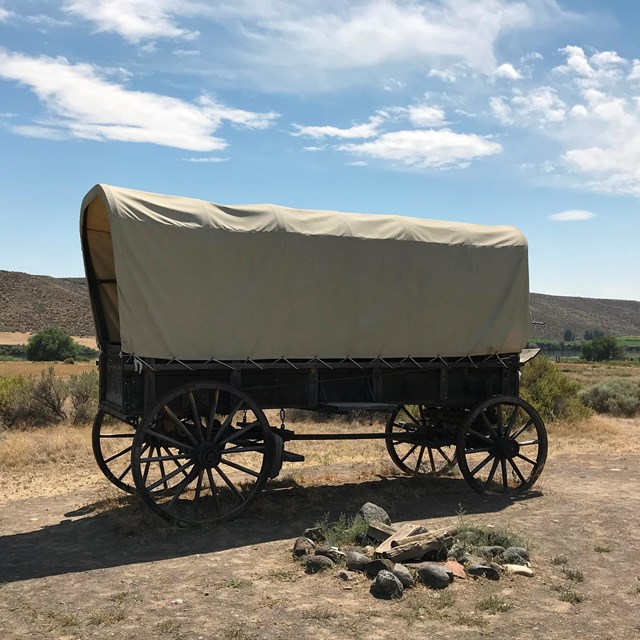
This horizontal sign is located on one side of the looping path to the right of the pavilion next to the parking area. The level paved path winds about 100 yards through meadow-like vegetation.
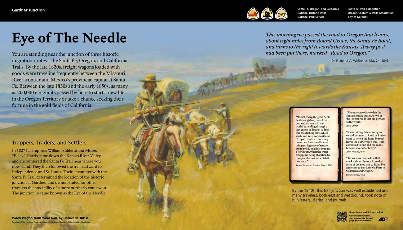
The background of this panel features a color painting titled "When Wagon Trails Were Dim" by Charles M. Russell, used courtesy of the National Cowboy & Western Heritage Museum, Oklahoma City, Oklahoma. It shows a low ridge of land covered with yellowed prairie vegetation. In the foreground a man holds a long rifle as he rides on horseback towards us. Behind him is a line of covered wagons pulled by teams of oxen.
Text on the left side of the panel reads, "You are standing near the junction of three historic migration routes - the Santa Fe, Oregon, and California Trails. By the late 1820s, freight wagons loaded with goods were traveling frequently between the Missouri River frontier and Mexico's provincial capital at Santa Fe. Between the late 1830s and the early 1850s, as many as 200,000 emigrants passed by here to start a new life in the Oregon Territory or take a chance seeking their fortune in the gold fields of California.
"Trappers, Traders, and Settlers. In 1827 fur trappers William Sublette and Moses "Black" Harris came down the Kansas River Valley and encountered the Santa Fe Trail near where you now stand. They then followed the trail eastward to Independence and St. Louis. Their encounter with the Santa Fe Trail determined the location of the historic junction at Gardner and demonstrated for other travelers the possibility of a more northerly route west. The junction became known as the Eye of the Needle."
At upper right on the panel is a quote from Dr. Frederick A. Wislizenus, May 24, 1846, which reads, "This morning we passed the road to Oregon that leaves, about eight miles from Round Grove, the Santa Fe Road, and turns to the right towards the Kansas. A way post had been put there, marked 'Road to Oregon.'"
At bottom right is an image of a notebook with quotes from travelers on the trails. The left page has a quote from Samuel Rutherford Dundass, May 1, 1849, which reads, "We left today, the great Santa Fe thoroughfare, one of the best natural roads in the world, extending through a vast extent of Prairie, so level that the dashing rains which wash, and keep constantly out of repair, roads in more hilly countries, have no effect on this great highway of nature, but to produce a little mud for a few hours, when the water disappears being absorbed by thee peculiar soil on which it descends."
On the right page of the notebook are three quotes. The top one is from James Clyman and reads, "About noon today we left the Santa fee trace these are two of the longest roads that are perhaps in the world."
The middle quote is from James Pritchard, 1849, which reads, "It was raining this morning and we did not start to 9 and in 8 miles came to where the Santa Fe road leaves the old Orregon trail. It still continued to rain and the roads became somewhat heavy."
The bottom quote is from Edmund Hinde, 1850, and reads, "We are now camped on Bull creek a short distance from the forks of the road one to Santa Fee and other to Salt Lake via Forts to California and Oragon."
The caption below the notebook reads, "By the 1840s, this trail junction was well established and many travelers, both east and westbound, took note of it in letters, diaries, and journals."
At bottom right on the panel is the Audio Description icon with text that reads, "Listen, Learn and Follow the Trail. Audio description available. Learn more and take the tour! Go.nps.gov/GardnerJunction."
There is also a QR code to take you to that web site.
Across the top of the panel is a black bar. At the left end text reads "Gardner Junction." At the right end are logos and text for the Santa Fe, Oregon, and California National Historic Trails, National Park Service." Other text reads, "Santa Fe Trail Association, Oregon-California Trails Association, and City of Gardner."
End of Description.
NPS Exhibit
Where the Trails Divide Exhibit Audio Description
-
Gardner Junction - Where the Trails Divide Exhibit Audio Description
Wayside interpretive exhibit, full audio description is available.
- Credit / Author:
- NPS
- Date created:
- 05/06/2025
Where the Trails Divide. 581 words.
This horizontal sign is located on one side of the looping path to the right of the pavilion next to the parking area. The level paved path winds about 100 yards through meadow-like vegetation.
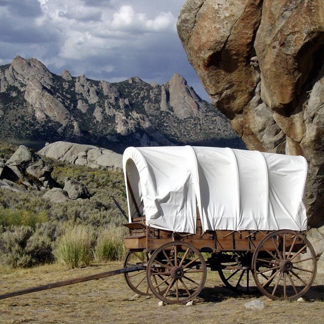
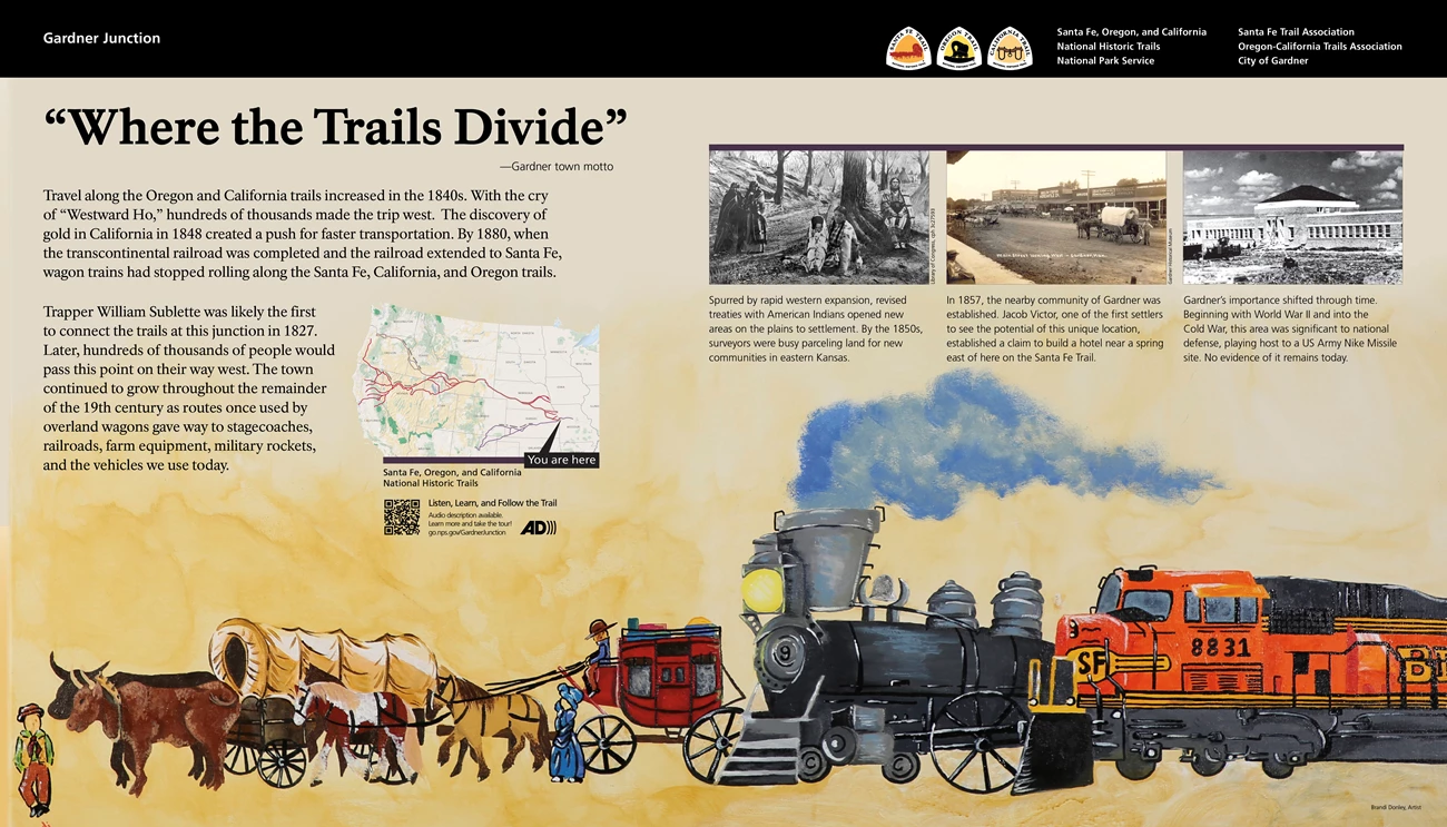
Across the bottom is a color illustration by Brandi Donley, Artist, showing the modes of travel for going west. At bottom left is a man standing in front of a covered wagon pulled by a pair of oxen. To the right behind the wagon is a red stagecoach pulled by horses. Next to the right is a steam locomotive. The final image on the right is an orange diesel locomotive.
At upper left is the panel title, "Where the Trails Divide" which is the Gardner town motto. Text on the left reads, "Travel along the Oregon and California trails increased in the 1840s. With the cry of 'Westward Ho,' hundreds of thousands made the trip west. The discovery of gold in California in 1848 created a push for faster transportation. By 1880, when the transcontinental railroad was completed and the railroad extended to Santa Fe, wagon trains had stopped rolling along the Santa Fe, California, and Oregon trails.
"Trapper William Sublette was likely the first to connect the trails at this junction in 1827. Later, hundreds of thousands of people would pass this point on their way west. The town continued to grow throughout the remainder of the 19th century as routes once used by overland wagons gave way to stagecoaches, railroads, farm equipment, military rockets, and the vehicles we use today."
Below the text is the Audio Description icon with text that reads, "Listen, Learn and Follow the Trail. Audio description available. Learn more and take the tour! Go.nps.gov/GardnerJunction."
There is also a QR code to take you to that web site.
In the upper right corner of the panel are three historic photographs, going left to right. The one at left shows a group of American Indians. A woman and child sit at the base of a tree trunk. A man sits nearby. Two other people stand to the left. The caption reads, "Spurred by rapid western expansion, revised treaties with Native Americans opened new areas on the plains to settlement. By the 1850s, surveyors were busy parceling land for new communities in eastern Kansas."
The middle photograph shows a wide dirt street lined by wooden buildings on the far side. A pair of horses pulling a covered wagon sits in the middle of the street. The caption reads, "In 1857, the nearby community of Gardner was established. Jacob Victor, one of the first settlers to see the potential of this unique location, established a claim to build a hotel near a spring east of here on the Santa Fe Trail."
The photo on the right shows a stone building under construction. It is a long one-story building with a taller, square section in the middle. The caption reads, "Gardner's importance shifted through time. Beginning with World War II and into the Cold War, this area was significant to national defense, playing host to a US Army Nike Missile site. No evidence of it remains today."
Across the top of the panel is a black bar. At the left end text reads "Gardner Junction." At the right end are logos and text for the Santa Fe, Oregon, and California National Historic Trails, National Park Service." Other text reads, "Santa Fe Trail Association, Oregon-California Trails Association, and City of Gardner."
End of Description.
NPS Exhibit
Why Go West Exhibit Audio Description
-
Gardner Junction - Why Go West Exhibit Audio Description
Wayside interpretive exhibit, full audio description is available
- Credit / Author:
- NPS
- Date created:
- 05/06/2025
Why Go West? 802 words.
This horizontal sign is located on one side of the looping path to the right of the pavilion next to the parking area. The level paved path winds about 100 yards through meadow-like vegetation.
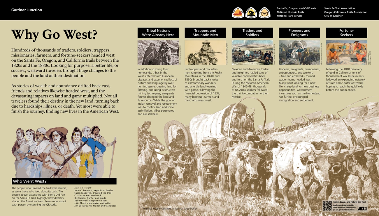
At bottom right is a brown and white illustration from Hastings House Publishers, artist Nick Eggenhoffer. Filling the foreground is a covered wagon pull by four oxen. A man and a woman sit at the front of the wagon. Standing to the right a man swings a long whip. Another man is on a horse to the left. Behind them a line of wagons stretches back and then curves to the right up a slope.
Text at upper left reads, "Hundreds of thousands of traders, soldiers, trappers, missionaries, farmers, and fortune-seekers headed west on the Santa Fe, Oregon, and California trails between the 1820s and the 1880s. Looking for purpose, a better life, or success, westward travelers brought huge changes to the people and the land at their destination.
"As stories of wealth and abundance drifted back east, friends and relatives likewise headed west, and the devastating impacts on land and game multiplied. Not all travelers found their destiny in the new land, turning back due to hardships, illness, or death. Yet most were able to finish the journey, finding new lives in the American West."
Below the text is an illustration showing seven people. The caption identifies them as, from left to right, John C. Fremont, expedition leader; Susan Magoffin, traveled the trail; Charlotte, enslaved cook; Kit Carson, hunter and guide; Yellow Wolf, Cheyenne leader; J.W. Abert, map maker and artist; Jim Beckwourth, trader and translator. Text below them reads, "Who Went West? The people who traveled the trail were diverse, as were those who lived along its path. The people above, associated with Bent's Old Fort on the Santa Fe Trail, highlight how diversity shaped the American West. Learn more about each person by scanning the QR code."
A upper right on the panel is a row of five images. Beginning at the left, the first is a historic photograph showing an American Indian man and woman, each wearing a striped blanket. Text reads, "Tribal Nations Were Already Here. In addition to losing their homelands, tribes in the West suffered from European diseases and experienced loss of culture and language. By over-hunting game, clearing land for farming, and using destructive mining techniques, emigrants forever changed the land and its resources. While the goal of Indian removal and resettlement was to control land and force assimilation, tribes persevered and are still here."
The next image is a drawing of a man with long beard and hair, sitting on a horse and holding a long rifle in front of him. Text reads, "Trappers and Mountain Men. Fur trappers and mountain men returning from the Rocky Mountains in the 1820s and 1830s brought back stories of extraordinary wonders and a fertile land teeming with game. Following the financial depression of 1837, many bankrupt farmers and merchants went west."
Next is a color illustration of a covered wagon with men wearing blue uniforms on horseback nearby. Text reads, "Traders and Soldiers. Mexican and American traders and freighters hauled tons of valuable commodities back and forth on the Santa Fe Trail. During the Mexican-American War of 1846 to 1848, thousands of US Army soldiers followed the trail to combat in northern Mexico."
The fourth image is another color illustration of a covered wagon pulled by a pair of oxen led by a man on horseback. Text reads, "Pioneers and Emigrants. Pioneers, emigrants, missionaries, entrepreneurs, and workers - free and enslaved - formed wagon trains headed west. Many went looking for a new life, cheap land, or new business opportunities. Government incentives such as the Homestead Act further encouraged immigration and settlement."
The image on the right is a brightly colored image showing miners at work. One man dips a pan into a stream. Another works at a wooden trough as a third wields a pickax. Text reads, "Fortune-Seekers. Following the 1848 discovery of gold in California, tens of thousands of would-be miners followed an expanding network of trails and cutoffs westward, hoping to reach the goldfields before the boom ended."
In the lower right corner is the Audio Description icon with text that reads, "Listen, Learn and Follow the Trail. Audio description available. Learn more and take the tour! Go.nps.gov/GardnerJunction."
There is also a QR code to take you to that web site.
Across the top of the panel is a black bar. At the left end text reads "Gardner Junction." At the right end are logos and text for the Santa Fe, Oregon, and California National Historic Trails, National Park Service." Other text reads, "Santa Fe Trail Association, Oregon-California Trails Association, and City of Gardner."
End of Description.
NPS Exhibit
American Indian Lands Exhibit Audio Description
-
Gardner Junction - American Indian Lands Exhibit Audio Description
Wayside interpretive exhibit, full audio description is available.
- Credit / Author:
- NPS
- Date created:
- 05/06/2025
American Indian Lands. 561 words.
This horizontal sign is located on one side of the looping path to the right of the pavilion next to the parking area. The level paved path winds about 100 yards through meadow-like vegetation.
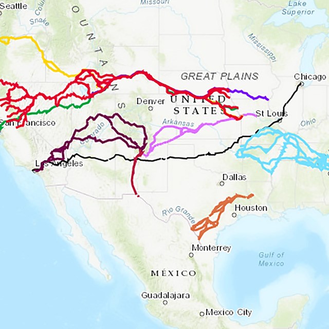
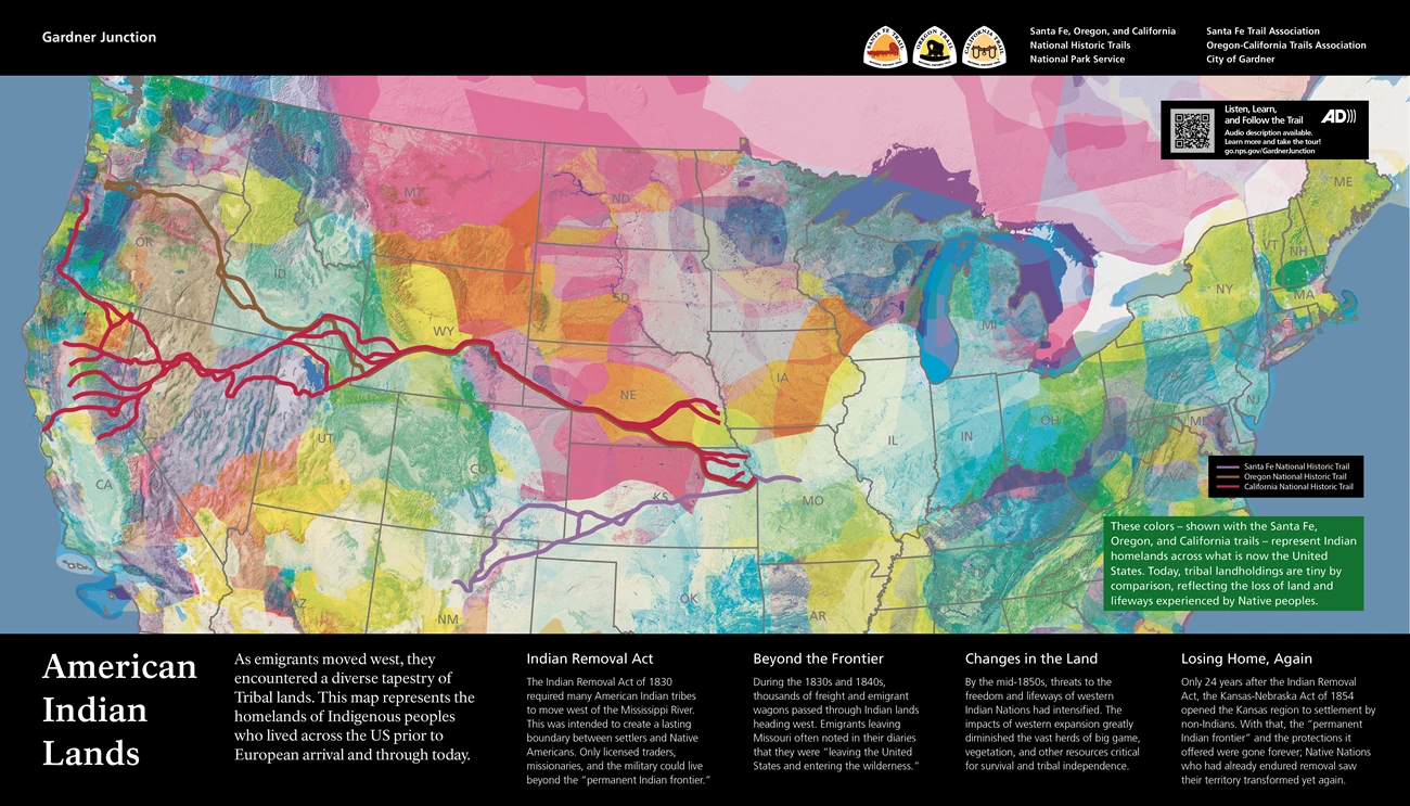
This panel features a map of the United States with the states outlined in gray. The map is covered with a mosaic of overlapping shapes in a variety of colors. Board lines indicate the paths of the Santa Fe, Oregon, and California National Historic Trails. The Santa Fe Trail is shown in purple and stretches from central Missouri across Kansas and into northeast New Mexico. An alternate loop goes from Kansas into Colorado and then down into New Mexico. The California Trail in red has several starting points in eastern Kansas and eastern Nebraska which then coalesce to move across Nebraska and Wyoming. It then splits into different paths to cross either Utah or Idaho before crossing Nevada and ending at a number of different points in California. The Oregon Trail follows the same path as the California Trail until southwest Wyoming where it splits off to head north across Idaho and into Oregon. A label on the right side of the map reads, "These colors - shown with the Santa Fe, Oregon, and California trails - represent Indian homelands across what is now the United States. Today, tribal landholdings are tiny by comparison, reflecting the loss of land and lifeways experienced by Native peoples."
Text across the bottom of the panel reads, "As emigrants moved west, they encountered a diverse tapestry of Tribal lands. This map represents the homelands of Indigenous peoples who lived across the US prior to European arrival and through today."
"Indian Removal Act. The Indian Removal Act of 1830 required many American Indian tribes to move west of the Mississippi River. This was intended to create a lasting boundary between settlers and Native Americans. Only licensed traders, missionaries, and the military could live beyond the "permanent Indian frontier.""
"Beyond the Frontier. During the 1830s and 1840s, thousands of freight and emigrant wagons passed through Indian lands heading west. Emigrants leaving Missouri often noted in their diaries that they were "leaving the United States and entering the wilderness.""
"Changes in the Land. By the mid-1850s, threats to the freedom and lifeways of western Indian Nations had intensified. The impacts of western expansion greatly diminished the vast herds of big game, vegetation, and other resources critical for survival and tribal independence."
"Losing Home, Again. Only 24 years after the Indian Removal Act, the Kansas-Nebraska Act of 1854 opened the Kansas region to settlement by non-Indians. With that, the "permanent Indian frontier" and the protections it offered were gone forever; Native Nations who had already endured removal saw their territory transformed yet again."
Across the top of the panel is a black bar. At the left end text reads "Gardner Junction." At the right end are logos and text for the Santa Fe, Oregon, and California National Historic Trails, National Park Service." Other text reads, "Santa Fe Trail Association, Oregon-California Trails Association, and City of Gardner."
Below the bar at upper right is the Audio Description icon with text that reads, "Listen, Learn and Follow the Trail. Audio description available. Learn more and take the tour! Go.nps.gov/GardnerJunction."
There is also a QR code to take you to that web site.
End of Description.