Last updated: January 15, 2023
Contact Us
Article
BLM Price Exhibits Audio Description
NPS/BLM Exhibit
NPS/BLM Exhibit
John Wesley Powell River History Museum Exhibit Audio Description
-
John Wesley Powell River History Museum Exhibit Audio Description
Listen to the audio description of the John Wesley Powell River History Museum exhibit.
- Date created:
- 12/02/2021
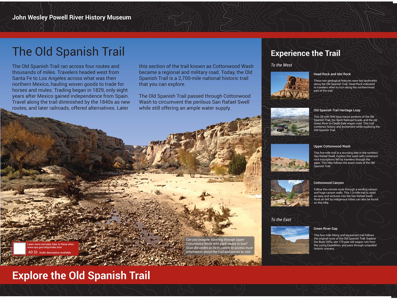
Exhibit 1 of 2 The exhibits are mounted on a large metal kiosk. There is a flat metal silhouette of traders and pack mules with small shrubs on top of the kiosk. The panel is 48 inches wide and 36 inches high. The kiosk is placed on the eastern side of the museum on the grass. There is a small, shaded area behind the sign and a flagpole. Title: The Old Spanish Trail. The exhibit has black and gray topographic line banners along the top and bottom. There is large text on the upper left portion of the panel along. On the right side there is a list of local places with text and pictures. A large photograph shows a sandstone canyon sparsely populated with yellow and orange cottonwood trees and small shrubs. The photo was taken in the bottom of the canyon where there is also a small puddle of water. It has been stylized to look like an oil painting. Primary Text: The Old Spanish Trail coursed across four routes and thousands of miles. Travelers headed west from Santa Fe, New Mexico, with woven goods to trade for horses and mules near Los Angeles, California. Large scale trading began in 1829, only eight years after Mexico gained independence from Spain. After new routes and railroads developed, use of the trail diminished by the late 1840s and it became a regional and military road. Today, the Old Spanish Trail is a 2,700-mile national historic trail that you can explore. The Old Spanish Trail passed through Cottonwood Wash to circumvent the perilous San Rafael Swell while still providing an ample water supply. Photo Caption: Can you imagine traveling through Upper Cottonwood Wash with pack mules in tow? Scan the codes on both panels to access more information about the trail and places to visit. At the bottom left of the photo there is a red text block with a QR code. Text block with QR code: Learn more and plan trips to these sites. nps.gov/places/john-wesley-powell-river-history-museum Audio description available.Secondary Text: Experience the Trail. On the right side of the panel there is a list of five points of interest with pictures and labels. To the right of each of the photos is a caption detailing more information about that place. Subtitle: To the west. Label title 1: Head Rock and Idol Rock AD: There is a photograph showing a sandstone cliff with a blue sky in the background. At the base of the cliff is dense green vegetation. The cliff face resembles the face of a man with a big nose and a furrowed brow facing west. Caption: These two geological features were key landmarks along the Old Spanish Trail. Head Rock indicated when to turn to follow the northernmost part of the trail. Label Title 2: Old Spanish Trail Heritage Loop AD: There is a photograph of ATVs driving toward the viewer. Vegetation is sparsely placed over the rocky landscape with smooth mountains in the background. Caption: This 30-mile OHV loop traces portions of the Old Spanish Trail, the Spirit Railroad Grade, and the old Green River to Castle Dale wagon road. This trail combines history and excitement while exploring the Old Spanish Trail. Label Title 3: Upper Cottonwood Wash AD: This is a photograph of a rocky hill amidst a clear blue sky. Small shrubs and other vegetation are scattered atop the sandy ground. Caption: This five-mile trail is a stunning hike in the northern San Rafael Swell. Explore this wash with numerous rock inscriptions left by travelers through the ages. This hike follows the exact route of the Old Spanish Trail. These two geological features were key landmarks along the Old Spanish Trail. Head Rock indicated to travelers when to turn along the northernmost part of the trail. Label Title 4: Cottonwood Canyon AD: There is a photograph with two large rock walls on both sides. At the bottom there is a sandy dry wash populated with lots of boulders and some small trees. Caption: Follow this remote route through a winding canyon and huge canyon walls. This 1.5-mile trail is rated as easy and ventures into the San Rafael Swell. Rock art left by Indigenous tribes can also be found on this hike.
Subtitle: To the east. Label Title 5: Green River Gap AD: This is a photograph of a barren landscape surrounded by tall cliffs. In the background there is a sky filled with wispy clouds. Caption: This four-mile hiking and equestrian trail follows the original route of the Old Spanish Trail. Explore the Book Cliffs, see 170-year-old wagon ruts from the Loring Expedition, and pass through unspoiled historic scenery.
Bottom Banner: Text: Explore the Old Spanish Trail.
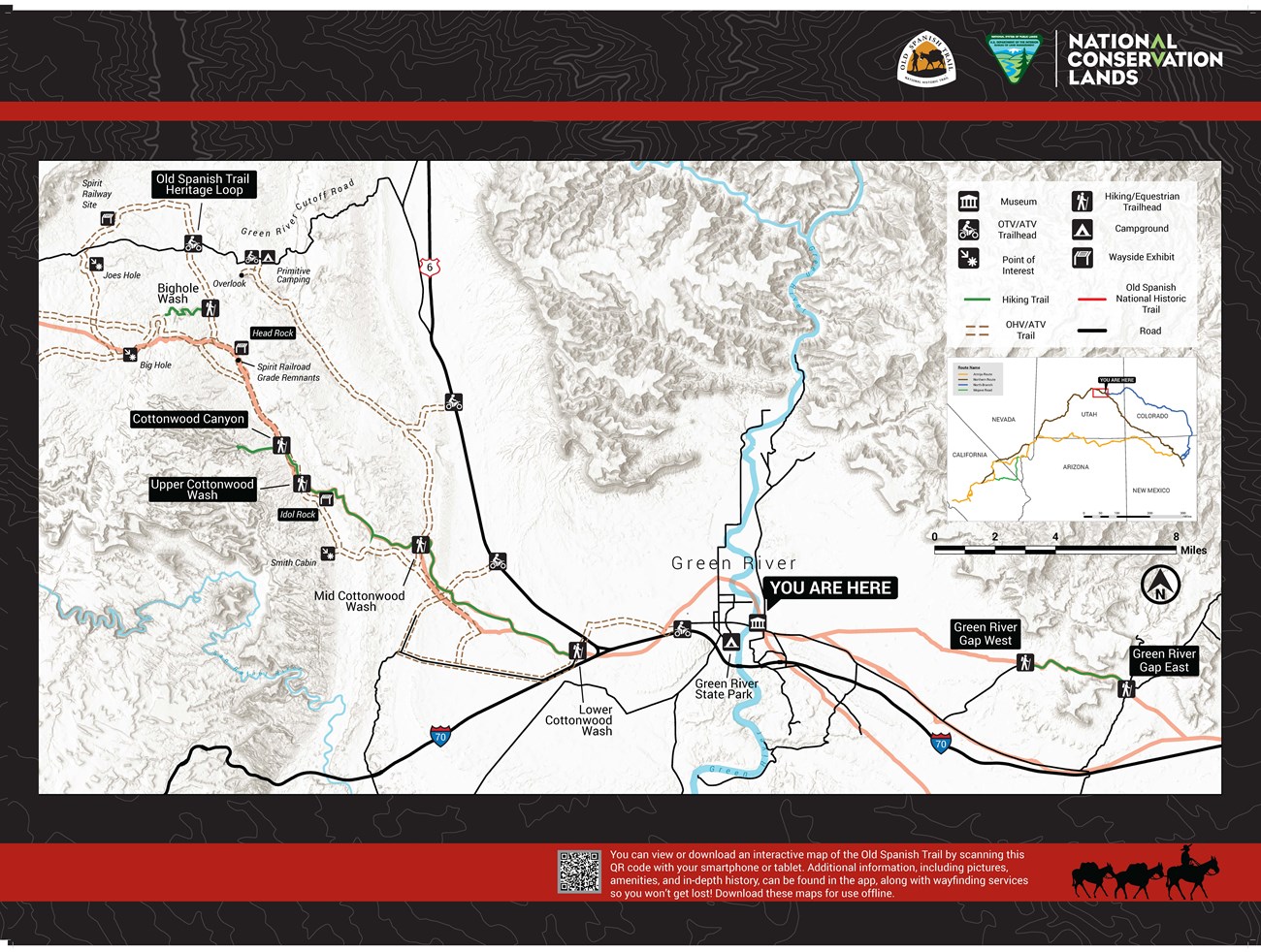
Exhibit 2 of 2 The exhibit has black and gray topographic lines as the background with two red banners along the top and bottom. A large area map takes up almost all the space on the panel. Map: This is a map of all the points of interest and trails along the Old Spanish Trail, and the Old Spanish Trail itself, for the eastern half of Emery County, and includes part of Grand County. The background is a gray hill shade layer of the topography of the area. A large ‘YOU ARE HERE’ label indicates you are just south of the Old Spanish Trail at the John Wesley Powell River History Museum in Green River. Almost all the points on the map are labeled, but the points mentioned on the first half of this exhibit, namely Upper Cottonwood Wash, Head Rock, Idol Rock, the Old Spanish Trail Heritage Loop, Cottonwood Canyon, and both trailheads for Green River Gap, have been bolded and outlined. All the beforementioned trails except Cottonwood Canyon show that they follow routes from the Old Spanish Trail. On the right-hand side of the mal, there is a legend, scale, north arrow, and inset map of the entire Old Spanish Trail. It shows four routes making up the entire trail, with a ‘YOU ARE HERE’ label showing that you are on the Northern Route section of the trail.
Bottom Red Banner:
Text Block with QR code: You can view or download an interactive map of the Old Spanish Trail by scanning this QR code with your smartphone or tablet. Additional information, including pictures, amenities, and in-depth history, can be found in the app, along with wayfinding services so you won’t get lost! Download these maps for use offline.
A black silhouette is set to the right of the text block. It shows a man with a cowboy hat sitting on top of a pack mule, with two other mules behind him in line attached by ropes.
NPS/BLM Exhibit
NPS/BLM Exhibit
Museum of the San Rafael Exhibit Audio Description
-
Museum of the San Rafael Exhibit Audio Description
Listen to the audio description of the Museum of the San Rafael exhibit.
- Date created:
- 12/02/2021
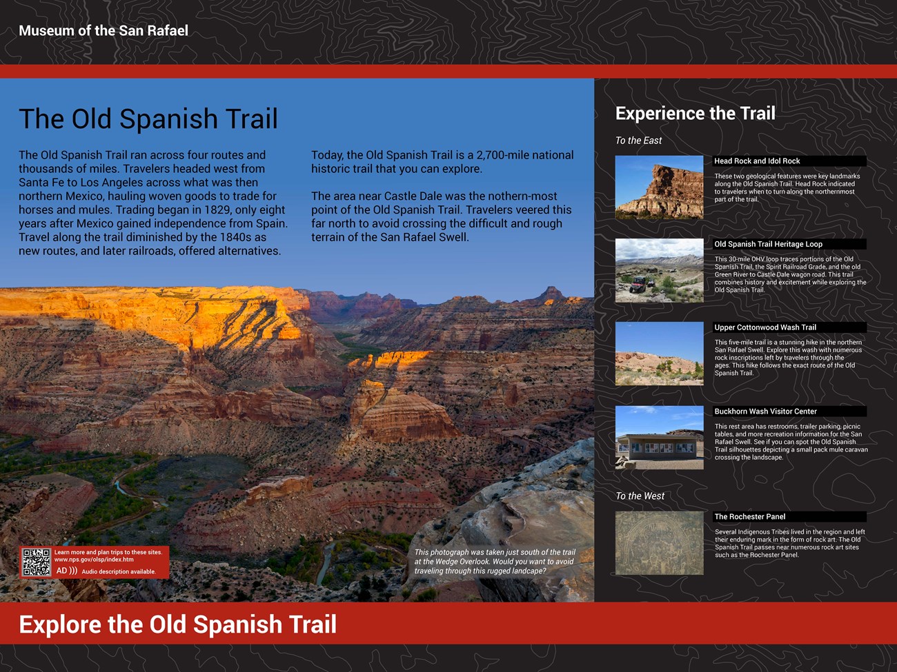
Exhibit 1 of 2 The exhibits are mounted on a large metal kiosk. There is a flat metal silhouette of traders and pack mules with small shrubs on top of the kiosk. The panel is 48 inches wide and 36 inches high. Title: The Old Spanish Trail. The exhibit has black and gray topographic line banners along the top and bottom. There is large text on the upper left portion of the panel. On the right side there is a list of local places with text and pictures. A large photograph shows an overview of a huge sandstone canyon sparsely dotted with green shrubs. There is a winding river at the bottom of the canyon surrounded by lush vegetation. It has been stylized to look like an oil painting. Primary Text: The Old Spanish Trail ran across four routes and thousands of miles. Travelers headed west from Santa Fe to Los Angeles across what was then northern Mexico, hauling woven goods to trade for horses and mules. Trading began in 1829, only eight years after Mexico gained independence from Spain. Travel along the trail diminished by the 1840s as new routes, and later railroads, offered alternatives. Today, the Old Spanish Trail is a 2,700-mile national historic trail that you can explore. The area near Castle Dale was the northern-most point of the Old Spanish Trail. Travelers veered this far north to avoid crossing the difficult and rough terrain of the San Rafael Swell. Photo Caption: This photograph was taken just south of the trail at the Wedge Overlook. Would you want to avoid traveling through this rugged landscape? At the bottom left of the photo there is a red text block with a QR code. Text block with QR code: Learn more and plan trips to these sites. nps.gov/places/museum-of-the-san-rafael.htm Audio description available.Secondary Text: Experience the Trail. On the right side of the panel there is a list of five points of interest with pictures and labels. To the right of each of the photos is a caption detailing more information about that place. Subtitle: To the East Label title 1: Head Rock and Idol Rock AD: There is a photograph showing a sandstone cliff with a blue sky in the background. At the base of the cliff is dense green vegetation. The cliff face resembles the face of a man with a big nose and a furrowed brow facing west. Caption: These two geological features were key landmarks along the Old Spanish Trail. Head Rock indicated when to turn to follow the northernmost part of the trail. Label Title 2: Old Spanish Trail Heritage Loop AD: There is a photograph of ATVs driving toward the viewer. Vegetation is sparsely placed over the rocky landscape with smooth mountains in the background. Caption: This 30-mile OHV loop traces portions of the Old Spanish Trail, the Spirit Railroad Grade, and the old Green River to Castle Dale wagon road. This trail combines history and excitement while exploring the Old Spanish Trail. Label Title 3: Upper Cottonwood Wash Trail AD: This is a photograph of a rocky hill amidst a clear blue sky. Small shrubs and other vegetation are scattered atop the sandy ground. Caption: This five-mile trail is a stunning hike in the northern San Rafael Swell. Explore this wash with numerous rock inscriptions left by travelers through the ages. This hike follows the exact route of the Old Spanish Trail. Label Title 4: Buckhorn Wash Visitor Center AD: This is a photograph of a covered information center with many interpretive panels of local points of interest. The kiosk is surrounded by gravel. Caption: This rest area has restrooms, trailer parking, picnic tables, and more recreation information for the San Rafael Swell. See if you can spot the Old Spanish Trail silhouettes depicting a small pack mule caravan crossing the landscape.
Subtitle: To the west. Label Title 5: The Rochester Panel AD: This is a photograph of a large collection of rock art on a single boulder. There is a big arch with many figures of all shapes and sizes surrounding it. Caption: Several Indigenous Tribes lived in the region and left their enduring mark in the form of rock art. The Old Spanish Trail passes near numerous rock art sites such as the Rochester Panel.
Bottom Banner: Text: Explore the Old Spanish Trail.
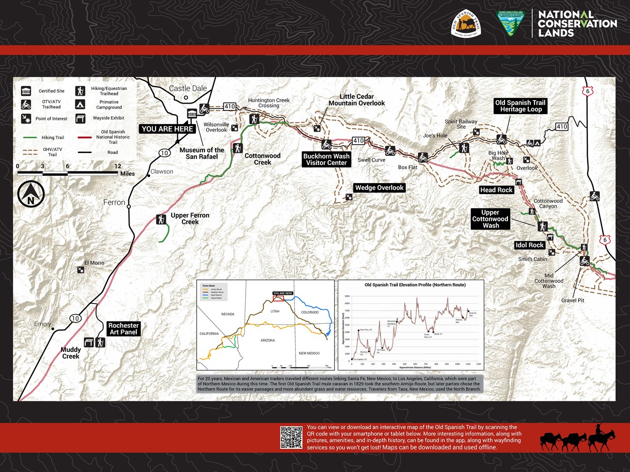
Exhibit 2 of 2 The exhibit has black and gray topographic lines as the background with two red banners along the top and bottom. A large area map takes up almost all the space on the panel. Map: This is a map of all the points of interest and trails along the Old Spanish Trail, and the Old Spanish Trail itself for the western half of Emery County. The background is a gray hill shade layer of the topography of the area. A large ‘YOU ARE HERE’ label indicates you are at the Museum of the San Rafael in Castle Dale. Almost all the points on the map are labeled, but the points mentioned on the first half of this exhibit, namely Upper Cottonwood Wash, Head Rock, Idol Rock, the Old Spanish Trail Heritage Loop, the Buckhorn Wash Visitor Center, the Wedge Overlook, and the Rochester Panel, have been bolded and outlined. Dashed double brown lines show the ATV trails and green lines show the hiking trails. On the left-hand corner of the map, there is a legend, scale, and north arrow. On the bottom center of the map, there is an inset map of the entire Old Spanish Trail. It shows four routes making up the entire trail, with a ‘YOU ARE HERE’ label showing that you are on the Northern Route section of the trail. Next to the inset map is a graph showing the differences in elevations as you cross the entire trail. Caption: For 20 years, Mexican and American traders traveled different routes linking Santa Fe, New Mexico, to Los Angeles, California, which were part of Northern Mexico during this time. The first Old Spanish Trail mule caravan in 1829 took the southern Armijo Route, but later parties chose the Northern Route for its easier passages and more abundant grass and water resources. Travelers from Taos, New Mexico, used the North Branch.
Bottom Red Banner:
Text Block with QR code: You can view or download an interactive map of the Old Spanish Trail by scanning this QR code with your smartphone or tablet. Additional information, including pictures, amenities, and in-depth history, can be found in the app, along with wayfinding services so you won’t get lost! Download these maps for use offline.
A black silhouette is set to the right of the text block. It shows a man with a cowboy hat sitting on top of a pack mule, with two other mules behind him in line attached by ropes.

NPS/BLM Exhibit
Emery County - Head Rock on the Old Spanish Trail Exhibit Audio Description
-
Emery County - Head Rock on the Old Spanish Trail Exhibit Audio Description
Listen to the audio description of the Emery County - Head Rock on the Old Spanish Trail exhibit.
- Date created:
- 09/09/2021
This exhibit is placed at a 45-degree angle a few feet off the ground. A cliff face is seen in the distance. The exhibit is 36 inches wide and 24 inches tall. Title: Landmarks Led the way. The exhibit has a textured background resembling black and dark gray rock layers. Two red horizontal banners frame the elements of the panel. There is a block of text above a map with a description. To the right is a large photograph of a large sandstone rock on a cliff and a clear blue background. The rocks are layered in a way that makes it look like a head with a long face, a big nose, and furrowed eyebrows. Caption: What do you think? Could you identify Head Rock if you were traveling on the Old Spanish Trail? Above the photograph is a black and white sketch of Head Rock. Caption: Original 1853 sketch by Richard Kern, a geologist with the Gunnison Expedition. Primary Text: In 1853 an expedition led by John W. Gunnison ventured into the American West for exploration on behalf of the United States government in search of a viable railroad route. They traveled on parts of the Old Spanish Trail and relied on landmarks to help guide them across this area. They followed the northern segment of the trail, crossing the landscape where you stand today. Head Rock, seen straight ahead, is an example of a landmark travelers would use. Map below Primary Text: Title: Routes of the Old Spanish Trail. The map shows the four routes of the Old Spanish Trail across the Western United States, spanning from New Mexico to California. The different routes, the Northern Route, the Armijo Route, the Northern Branch, and the Mojave Road, converge and separate at various places along the trail. Along the trail, major cities are labeled. A red square indicates that you are on the Northern Route section in east-central Utah. Caption: The Old Spanish National Historic Trail spans thousands of miles across New Mexico, Colorado, Utah, Arizona, Nevada, and California. Between 1829 and 1848, New Mexican traders used pack mules to bring woven goods to California. There, they would trade their goods for horses and mules. The North Branch and Northern Route became successful, well-used routes. Features for more information: Beneath the map there are two blocks containing text and QR codes. Text block 1 with QR code: Learn more about these sites. https://www.nps.gov/olsp/index.htmText block 2 with QR code: Audio description available go.nps.gov/HeadRockUT
Bottom Red Banner:
Text: Explore the Old Spanish Trail.
Text Block 3 with QR code: Travel the trail with the Explorer app to go on a self-guiding adventure! Maps can be downloaded and used offline.
A black silhouette set to the right of the text block shows a man with a cowboy hat sitting on top of a pack mule, with two other mules behind him in line attached by ropes.
NPS/BLM Exhibit
Emery County - Idol Rock on the Old Spanish Trail Exhibit Audio Description
-
Emery County - Idol Rock on the Old Spanish Trail Exhibit Audio Description
Listen to the audio description of the Emery County - Idol Rock on the Old Spanish Trail exhibit.
- Date created:
- 09/09/2021
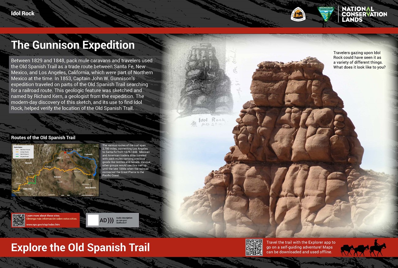
This exhibit is placed at a 45-degree angle a few feet off the ground. A sandstone cliff face is seen in the distance. The exhibit is 36 inches wide and 24 inches tall. The exhibit has a textured background resembling black and dark gray rock layers. Title: The Gunnison Expedition. Two red horizontal accents frame the elements of the panel. There is a block of text above a map with a description. To the right is a large photograph of a tall and heavily weathered sandstone rock with a white background. In the top left of the photograph there is a black and white sketch of the rock, labeled in pencil as Idol Rock, with other illegible writings. Caption: Travelers gazing upon Idol Rock could have seen it as a variety of different things. What does it look like to you? Primary Text: Between 1829 and 1848, pack mule caravans and travelers used the Old Spanish Trail as a trade route between Santa Fe, New Mexico and Los Angeles, California, which were part of Northern Mexico at the time. In 1853, Captain John W. Gunnison’s expedition traveled on parts of the Old Spanish Trail searching for a railroad route. This geologic feature was sketched and named by Richard Kern, a geologist from the expedition. The modern-day discovery of this sketch, and its use to find Idol Rock helped verify the location of the Old Spanish Trail. Map below Primary Text: Title: Routes of the Old Spanish Trail. The map shows the four routes of the Old Spanish Trail across the Western United States, spanning from New Mexico to California. The different routes, the Northern Route, the Armijo Route, the Northern Branch, and the Mojave Road, converge and separate at various places along the trail. Along the trail, major cities are labeled. A red square indicates that you are on the Northern Route section in Eastern Utah. Caption: The various routes of the trail span 2,700 miles, connecting Los Angeles to Santa Fe from 1829-1848. Mexican and American traders alike traveled with pack mules carrying precious goods like textiles and horses. Various other groups would use this trail up until the late 1860s when the railroad connected the Great Plains to the Pacific coast. Features for more information: Beneath the map there are two blocks containing text and QR codes. Text block 1 with QR code: Learn more about these sites. https://www.nps.gov/olsp/index.htm Text block 2 with QR code: Audio description available go.nps.gov/IdolRockUT Bottom Red Banner:Text: Explore the Old Spanish Trail.
Text Block 3 with QR code: Travel the trail with the Explorer app to go on a self-guiding adventure! Maps can be downloaded and used offline.
A black silhouette is set to the right of the text block. It shows a man with a cowboy hat sitting on top of a pack mule, with two other mules behind him in line attached by ropes.
NPS/BLM Exhibit
Emery County - Muddy Creek Exhibit Audio Description
-
Emery County - Muddy Creek Exhibit Audio Description
Listen to the audio description of the Emery County - Muddy Creek exhibit.
- Date created:
- 12/02/2021
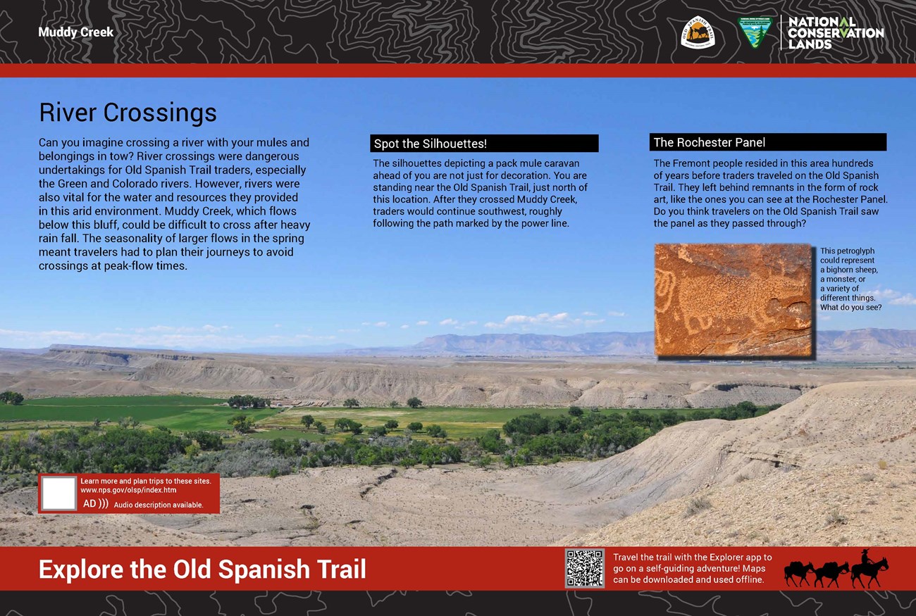
This exhibit is placed at a 45-degree angle a few feet off the ground and is 36 inches wide and 24 inches tall. The exhibit has a textured background resembling black and dark gray rock layers. Two red horizontal accents frame the elements of the panel. Title: River Crossings Primary Text: Can you imagine crossing a river with your belongings and pack mules in tow? River crossings were dangerous undertakings for Old Spanish Trail traders, especially the Green and Colorado Rivers. However, rivers were also vital for the water and resources they provided in this arid environment. Muddy Creek, which flows below this bluff, could be difficult to cross after heavy rain fall. The seasonality of larger flows in the spring caused travelers to plan their journeys to avoid crossings at peak-flow times. Secondary Text: Title: Spot the Silhouettes! Text: The silhouettes depicting a pack mule caravan ahead of you are not just for decoration. You are standing in near proximity to the Old Spanish Trail, north of this location. After they crossed Muddy Creek, traders would continue southwest, roughly following the path marked by the power line. Additional Secondary Text: Title: The Rochester Panel Text: The Fremont culture resided in this area hundreds of years before traders traveled on the Old Spanish Trail. This culture left remnants in the form of rock art. Do you think the Old Spanish Trail travelers stopped and saw the Rochester Panel? Photograph below Additional Secondary Text: There is a small photograph from a portion of the rock art panel of a figure representing a large, four-legged creature or animal. Caption: This petroglyph could represent a bighorn sheep, a monster, or a variety of different things. What do you see? Features for more information: At the bottom left of the panel there are two blocks containing text and QR codes.Text block 1 with QR code: Learn more about these sites. https://www.nps.gov/olsp/index.htm
Text block 2 with QR code: Audio description available go.nps.gov/muddy-creek-emery-county.htm
Bottom Red Banner: Text: Explore the Old Spanish Trail. Text Block 3 with QR code: Travel the trail with the Explorer app to go on a self-led adventure! Maps can be downloaded and used offline. A black silhouette is set to the right of the text block. It shows a man with a cowboy hat sitting on top of a pack mule, with two other mules behind him in line attached by ropes.

NPS/BLM Exhibit
Old Spanish Trail Heritage Loop Exhibit Audio Description
-
Old Spanish Trail Heritage Loop Exhibit Audio Description
Listen to the audio description Old Spanish Trail Heritage Loop exhibit.
- Date created:
- 04/27/2022
The kiosk is about 5 feet tall. The exhibit is 36 inches tall and 24 inches wide. The surro¬¬unding landscape is dry, flat in some places, and hilly in others, with sagebrush and cottonwood trees spread throughout. The exhibit has a textured background resembling black and dark gray rock layers. Two red banners frame the top and bottom of the panel. Title: Hit the Trail! Primary Text: Welcome to the Old Spanish Trail Heritage Loop. This 30-mile OHV trail follows the Cottonwood and Lost Spring washes. Old Spanish Trail pack mule caravans journeyed through Cottonwood Wash. Both later became wagon roads to connect Green River and Castle Dale. Keep an eye out for a 19th-century historic cabin and stone culverts. If you hike, locate the axle grease inscriptions along the Upper Cottonwood Wash Trail. Look for the large geographical features such as Head Rock and Idol Rock that provided wayfinding for early travelers. Map Below Primary Text: A large map shows the entirety of the Old Spanish Trail Heritage Loop, which starts towards the northwest corner of the map and extends down to the southeast corner. Several geological features are labeled, including Chimney Rock in the northwest corner, Horse Heaven towards the center, and the Book Cliffs at the far east of the map. There are also several labeled roads, including Highway 6 to the right and the Green River Cutoff Road, where the Loop trailhead is located. At the top of the map, on the north end of the loop, is a large YOU ARE HERE marker, indicating that you are at the trailhead of the loop. Along the loop the major stopping points are labeled, such as Bighole Wash, Head Rock, Cottonwood Canyon, Upper Cottonwood Wash, Idol Rock, Smith Cabin, Mid Cottonwood Wash, and two Overlook points. Photos to the Right of Map: There are three photos to the right of the map. The first photo is Head Rock. The photo shows a large, tall, layered brown cliff face. Along the bottom of the cliff face are cottonwood trees. The second photo is Smith Cabin. The photo shows a small, single-room cabin with an entryway. The door has fallen off and is on the ground leaning against the cabin. A single plank of wood dangles from the roof. The third photo is a stone culvert. Large, slim rocks are layered on top of each other, with an opening below them for drainage. Dry grass and dirt surround the culvert. Text Below Map: Title: Respect and Protect Travel responsibly, stay on routes. Pack it in, pack it out. Respect other users. Let someone know where you are going and when you plan to return. Help preserve these heritage sites, take only photos. For more information visit treadlightly.org Title: Need to Know The rough terrain is difficult to access after heavy rain or snow. Lost Spring Wash is rugged while Cottonwood Wash offers interpretive sites and hiking trails. High clearance and 4-wheel drive are required for the Lost Spring route and highly recommended for the Cottonwood route. This is a remote part of the San Rafael Swell; there are no amenities and cell service is very limited. Call 911 in an emergency. Features for more information At the bottom right of the panel is a block containing text and a QR code. Text with QR code: Learn more and plan trips to these sites. www.nps.gov/olsp Audio description available. go.nps.gov/OSTHeritageLoop Bottom Red Banner: Text: Explore the Old Spanish Trail Text with QR code: Travel the trail with the Explorer app to go on a self-guided adventure! Maps can be downloaded and used offline. A black silhouette is set to the right of the text block. It shows a man with a cowboy hat sitting on top of a pack mule, with two other mules behind him in line attached by ropes.End of Description
NPS/BLM Exhibit
NPS/BLM Exhibit
Emery County - Upper Cottonwood Wash Exhibit Audio Description
-
Emery County - Upper Cottonwood Wash Exhibit Audio Description
Listen to the audio description of the Emery County - Upper Cottonwood Wash exhibit.
- Date created:
- 09/09/2021
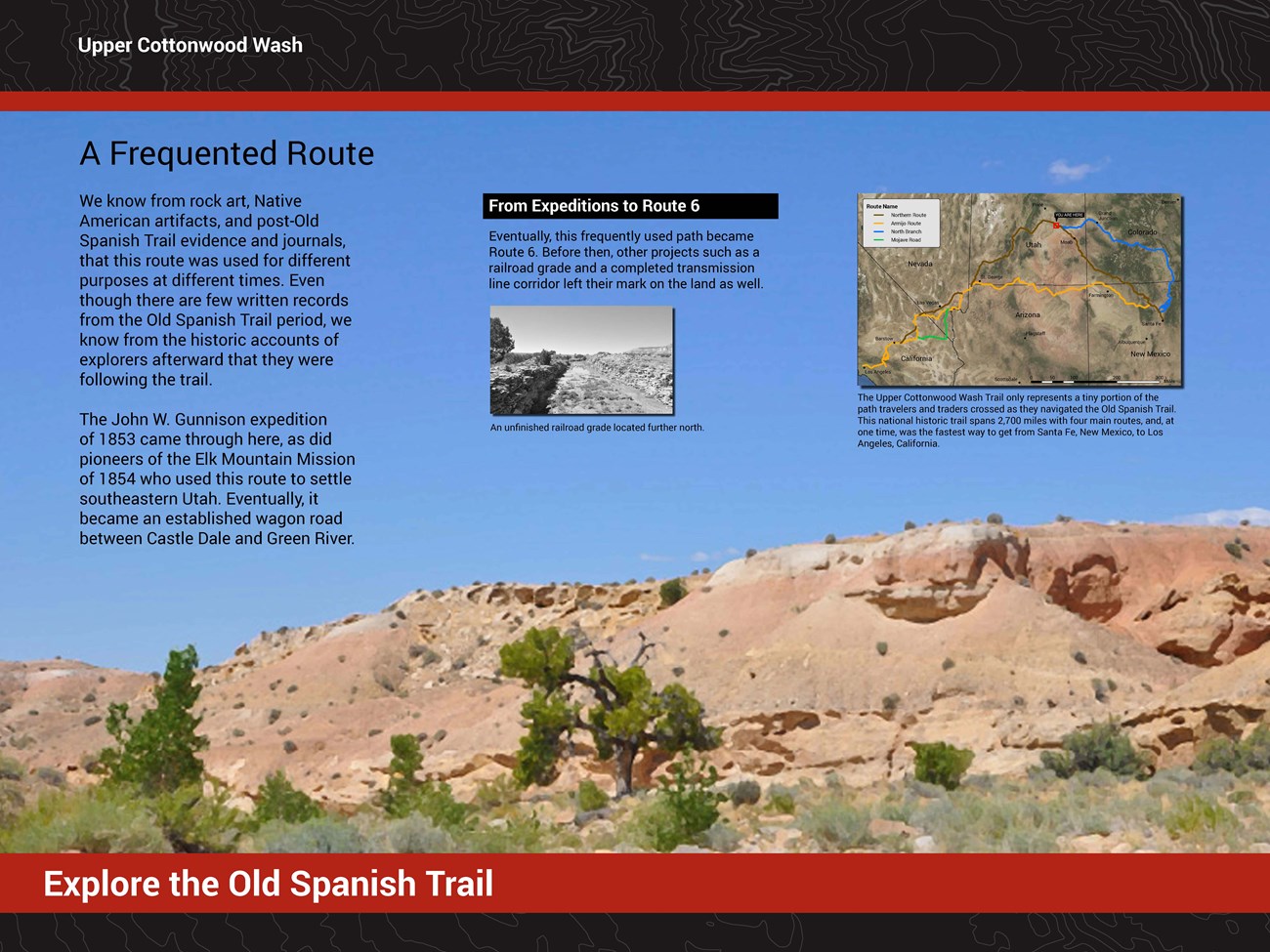
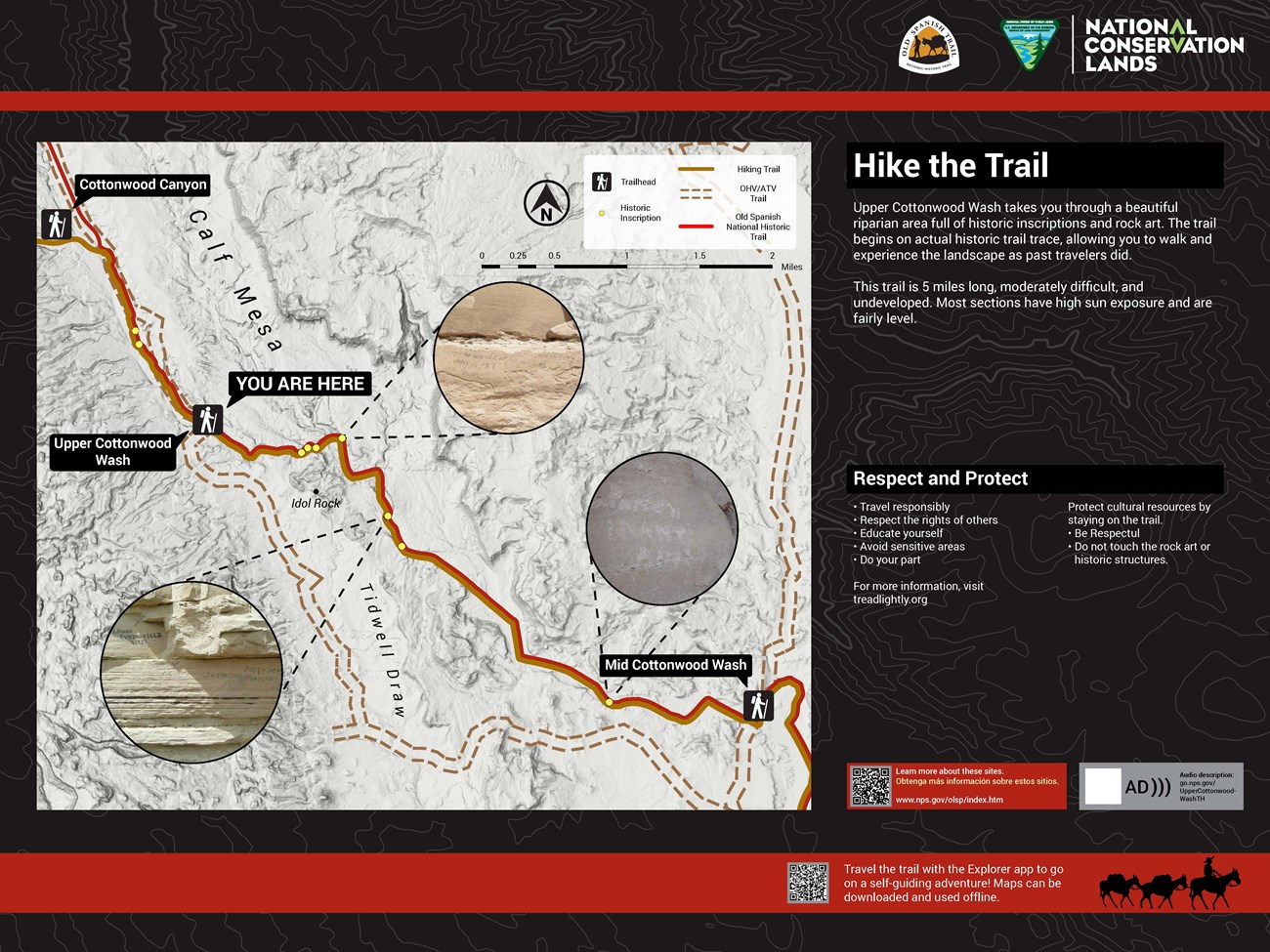
Exhibit 1 of 2 The exhibits are mounted on a large metal kiosk. There is a flat metal silhouette of traders and pack mules with small shrubs on top of the kiosk. Each panel is 48 inches wide and 36 inches high. Title: A Frequented Route. The exhibit has black and gray topographic line banners along the top and bottom. There is text on the upper section of the exhibit along with a photograph and a map. A large photograph shows a clear blue sky in the background with a sandstone hill with shrubs and cottonwood trees at its base in the foreground. The photo has been stylized to look like an oil painting. Primary Text: We know from rock art, Native American artifacts, and post-Old Spanish Trail evidence and journals, that this route was used for different purposes at different times. Even though there are few written records from the Old Spanish Trail period, we know from the historic accounts of explorers afterward that they were following the trail. The John W. Gunnison expedition of 1853 came through here, as did pioneers of the Elk Mountain Mission of 1854 who used this route to settle southeastern Utah. Eventually, it became an established wagon road between Castle Dale and Green River. Secondary Text: From Expeditions to Route 6 Eventually, this frequently used path became Route 6. Before then, other projects such as a railroad grade and a completed transmission line corridor left their mark on the land as well. AD: A black and white photograph shows a small ditch extending into the distance between two vertical walls of sandstone. There are small puddles of water and vegetation at the bottom of the ditch. Outside the ditch, the landscape is dry, and sagebrush is abundant. A partial view of a cottonwood tree can be seen to the left, and on the right, there is a sandstone cliff in the background. Caption: An unfinished railroad grade located further north. Map to the right of secondary text: AD: The map shows the four routes of the Old Spanish Trail across the Western United States, spanning from New Mexico to California. The different routes, the Northern Route, the Armijo Route, the Northern Branch, and the Mojave Road, converge and separate at various places along the trail. Along the trail, major cities are labeled. A red square indicates that you are on the Northern Route section in Central Utah. Caption: The Upper Cottonwood Wash Trail only represents a tiny portion of the path travelers and traders crossed as they navigated the Old Spanish Trail. This national historic trail spans 2,700 miles with four main routes, and, at one time, was the fastest way to get from Santa Fe, New Mexico, to Los Angeles, California. Exhibit 2 of 2 The background of the exhibit consists of black and gray topographic lines with two thin red banners along the top and bottom. There is a large map that takes up much of the space, with two blocks of text to the right. Map: This is a map of the Upper Cottonwood Wash trail. The trail stretches northwest to southeast starting at the Cottonwood Canyon trailhead, continuing to the Upper Cottonwood Wash trailhead, and ending at the Mid Cottonwood Wash Trailhead. A ‘YOU ARE HERE’ placard indicates that the reader is at the Upper Cottonwood Wash trailhead. Along the trail, dots indicate the locations of historic inscriptions that have been written on the walls of the wash. Several dots have callouts with pictures of the inscription at the given location. Primary Text: Hike the Trail! Upper Cottonwood Wash takes you through a beautiful riparian area full of historic inscriptions and rock art. The trail begins on actual historic trail trace, allowing you to walk and experience the landscape as past travelers did. This trail is 5 miles long, moderately difficult, and undeveloped. Most sections have high sun exposure and are fairly level. Secondary Text: Respect and Protect • Travel responsibly • Respect the rights of others • Educate yourself • Avoid sensitive areas • Do your part For more information, visit treadlightly.org Protect cultural resources by staying on the trail. • Be Respectful • Do not touch the rock art or historic structures.Features for more information: Beneath the secondary text there are two blocks containing text and QR codes. Text block 1 with QR code: Learn more and plan trips to these sites. https://www.nps.gov/olsp/index.htm
Text block 2 with QR code: Audio description available go.nps.gov/UpperCottonwoodWashTH
Bottom Red Banner:
Text Block 3 with QR code: Travel the trail with the Explorer app to go on a self-guiding adventure! Maps can be downloaded and used offline.
A black silhouette is set to the right of the text block. It shows a man with a cowboy hat sitting on top of a pack mule, with two other mules behind him in line attached by ropes.
