Primitive Camping in the Apostle Islands National LakeshoreCamping is available outside of individual or group campsites on all islands except Devils, Eagle, Gull, Long, Raspberry, and York. Primitive camping zones have been established on the rest of the islands for visitors seeking a remote backcountry experience with no facilities. Camping zone maps are available at the headquarters visitor center and in the text below. A fee of $15/party/night will be charged. An additional reservation fee of $10 is charged for each camping trip. To reserve a primitive camping zone go to recreation.gov or call the Bayfield Visitor Center at 715-779-3397 extension 2 for more information. The following areas are CLOSED to camping:
|
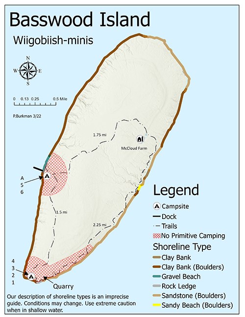
NPS Photo Basswood IslandWiigobiish-minis (Basswood Island) is located 4 miles from Bayfield. Acres: 1,910 Square Miles: 3.1 square miles Length: 3.3 miles Width: 1.2 miles Miles of Shoreline: 7.8 miles Elevation above Lake: 188 feet The no primitive camping zones are located 1/4 mile around the dock on the west side of the island near camp sites 5 & 6, 1/4 mile around the southern tip of the island near campsites 1-4, and a one mile stretch along the loop trail on the southeast side of the island. The entire west and south side of Basswood consists of a steep clay bank and boulders, with the exception of 0.25 miles of gravel beach located on the west side docking area. The north and east side of the island is made up of sandstone boulders. There is one small sandy beach with boulders located in the middle of the island on the east side. 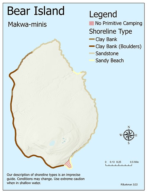
NPS Photo Bear IslandMakwa-minis (Bear Island) is located 14 miles from Bayfield.Acres: 1,824 Square Miles: 2.8 Length: 2.5 miles Width: 1.7 miles Miles of Shoreline: 6.8 miles Elevation above the lake: 233 feet There are no official camp sites on Bear Island, and the no primitive camping area is 1/4 mile along the sand spit on the southeast corner of the island. Bear Island consists mostly of clay banks with boulders. Another small sand beach area is located on the northeast side approximately 1 mile south of the northern most tip that boaters can access. 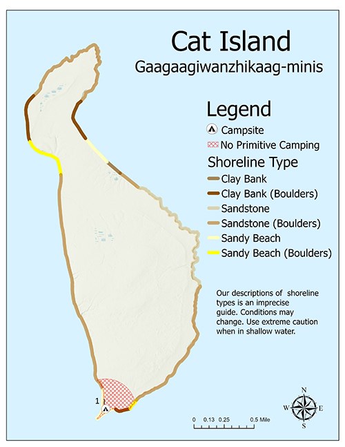
NPS Photo Cat IslandGaagaagiwanzhikaag-minis (Cat Island) is located 18 miles from Bayfield.Acres: 1,342 Square Miles: 2.1 Miles Length: 3.0 Miles Width: 1.1 Miles Miles of Shoreline: 8.6 Miles Elevation above Lake: 81 feet The no primitive camping zone is located at the southern tip of Cat Island a 1/4 mile around the sand spit and official campsite 1. The second sandy beach that is ideal for kayakers is located on the northeast side of the island, approximately 1.25 miles south of the northern tip. The third sand beach with boulders is located approximately 1.5 miles south from the northern tip on the western side of the island. The rest of the shore line is a mix of claybank and sandstone boulders. 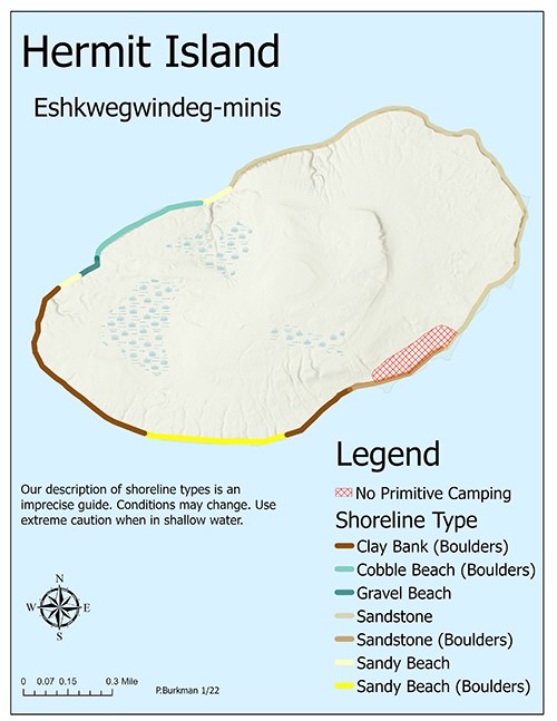
NPS Photo Hermit IslandEshkwegwindeg-minis (Hermit Island) is located 7.5 miles from Bayfield. Hermit has no dock.Acres: 733 miles Square Miles: 1.2 miles Length: 1.8 miles Width: 0.9 miles Miles of Shoreline: 3.9 miles Elevation above Lake: 176 feet While there are no official campsites on Hermit Island, primitive camping is still permitted on a 1/2 mile stretch of clay banks with boulders near the historic rock quarry on the southern side of the island. There is a 0.75 mile sand beach with boulders on the southeastern portion of the island that boaters can access. Two smaller sand beaches with a 0.75 mile cobble & gravel beach connect the two on the northwest shoreline. The rest of the island shoreline is sandstone and clay banks with boulders. 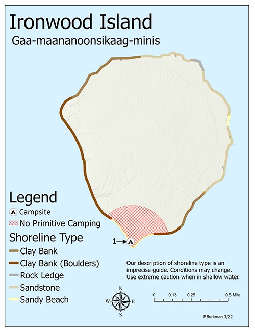
NPS Photo Ironwood IslandGaa-maananoonsikaag-minis (Ironwood Island) is located 16 miles from Bayfield.Acres: 659 Square Miles: 1.0 miles Length: 1.3 miles Width: 1.1 miles Miles of Shoreline: 4.0 miles Elevation above Lake: 78 feet The no primitive camping zone encompases a 0.5 mile shoreline on the southern end of the islands sandy beach area. On either side of the southern sandy beach is sandstone and clay banks. A second small sandy beach is located in the middle of the island's eastern shoreline. A small rock ledge lies 0.75 miles north of that sandy. The majority of the island shoreline is claybank and sandstone. 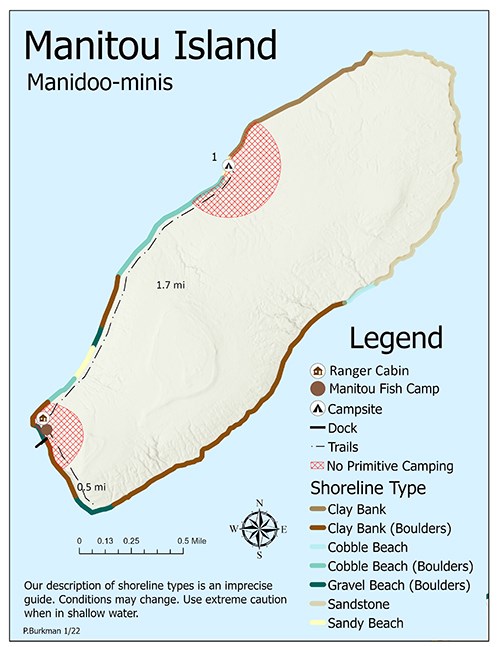
NPS Photo Manitou IslandManidoo-minis (Manitou Island) is located 12 miles from Bayfield.Acres: 1,363 Square Miles: 2.1 miles Length: 2.7 miles Width: 1.0 miles Miles of Shoreline: 7.1 miles Elevation above Lake: 128 feet There are three no primitive camping zones located on Manitou Island. The first one is a 1/2 mile of shoreline around campsite 1. The second is a 1/2 mile of shoreline on the southwest corner near the volunteer NPS living quarters, and the third is around the historic Manitou fish camp on the southern corner. The best place for boaters to access Manitou Island is small sand beach north of the dock and volunteer headquarters. The majority of the island is clay banks and sandstone. Be Aware: Watch for the shallow reef that connects Little Manitou rock to Manitou Island located 0.75 miles off the dock in the southwest corner of the island. 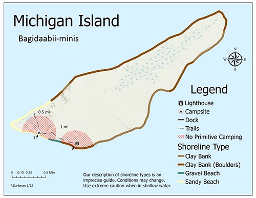
NPS Photo Michigan IslandBagidaabii-minis (Michigan Island) is located 16 miles from Bayfield. Acres: 1,578 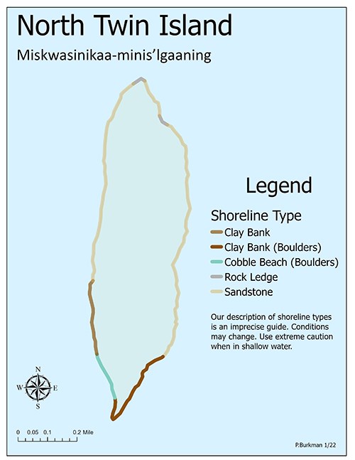
NPS Photo North Twin IslandMiskwasinikaa-minis-igaaning (North Twin Island) is located 22 miles from Bayfield. There is no dock on North Twin.Acres: 175 Square Miles: 0.3 miles Length: 1.2 miles Width: 0.3 miles Miles of Shoreline: 2.6 miles Elevation above Lake: 38 feet You can primitive camp anywhere on North Twin Island, but it is not easy to access by boat. The very southern tip of the island's shoreline and all the way up the east side is clay banks with boulders and sandstone. There is a 0.25 mile cobble beach with boulders on the south west side and the remaining northern shoreline consists of sandstone and a rock ledge at the northern most point. 
NPS Photo Oak IslandMitigominikaani-minis (Oak Island) is located 10 miles from Bayfield and 10 miles from Little Sand Bay. Oak Island has the highest elevation of all the Apostle Islands.Acres: 5,078 Square Miles: 7.9 miles Length: 4.0 miles Width: 2.5 miles Miles of Shoreline: 11.7 miles Elevation above Lake: 479 feet The no primitive camping zones are all 1/2 mile of shoreline around the official campsites, the NPS ranger station, and the dock. Oak Island shoreline is very diverse. The best place for kayakers to access the island is the four sandy beaches scattered along the shoreline. The first stretch is 1/2 mile long north of campsite 4. The second and third are on either side of campsite 6, and the fourth is 0.75 miles of shoreline on the southeastern corner. The remaining shoreline is a majority of clay banks with boulders. 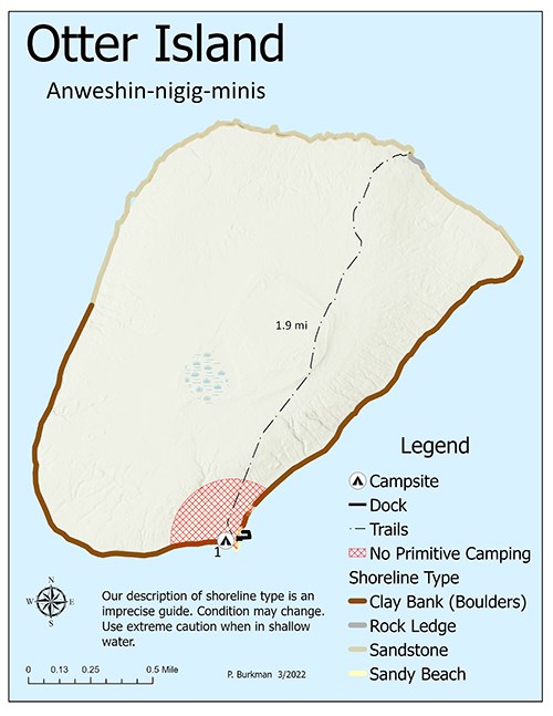
NPS Photo Otter IslandAnweshin-nigig-minis (Otter Island) is located 14 miles from Bayfield and 14 miles from Little Sand Bay. Acres: 1,333 Square Miles: 2.1 miles Length: 2.0 miles Width: 1.3 miles Miles of Shoreline: 5.8 miles Elevation above Lake: 138 feet The no primitive camping zone is a 1/2 mile of shoreline located at the southern tip near campsite 1 and the dock. Otter Island is hard to access with a kayak. The majority of shoreline is clay banks with boulders and sandstone. The trail running through the island ends on the north side on a small rock ledge. 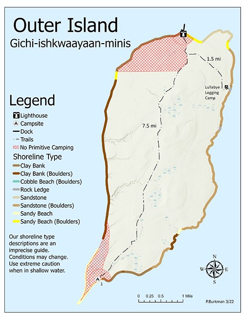
NPS Photo Outer IslandGichi-ishkwaayaan-minis (Outer Island) sand spit is located 24 miles from Bayfield and the lighthouse is 28 miles.Acres: 7,999 Square Miles: 12.5 miles Length: 7.0 miles Width: 2.8 miles Miles of Shoreline: 16.8 Elevation above Lake: 268 feet The two no primitive camping zones on Outer Island consists of 4 miles of shoreline on the southern sand spit near campsite 1 and 2.5 miles of shoreline on the northwest corner including the lighthouse and dock. Just east of the lighthouse is a 0.75 mile sandy beach with boulders. The majority of Outer Island is hard to access by kayak and is made up of clay banks with boulders and sandstone rock ledges. 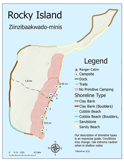
NPS Photo Rocky IslandZiinsibaakwado-minis (Rocky Island) is located 18 miles from Bayfield.Acres: 1,100 Square Miles: 1.7 miles Length: 3.1 Width: 1.0 miles Miles of Shoreline: 7.9 miles Elevation above Lake: 99 feet The no primitive camping zone is a 1/4 mile around campsites 1-5 on the southeastern side of the island, which encompasses over 2 miles of the southeastern shoreline. North of the official camp sites there is 1.5 miles of sandy beach shoreline that is accessible to boaters. Another sandy beach accessible on Rocky is in the middle of the arm that extends northeast. The remainder of the island is made up of clay banks, cobble beaches, and sandstone. 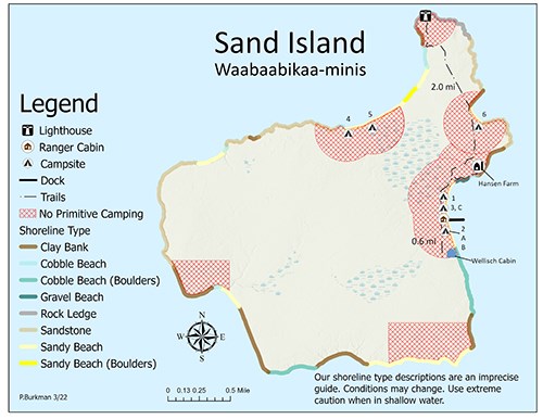
NPS Photo Sand IslandWaabaabikaa-minis (Sand Island) East Bay dock is located 20 miles from Bayfield and 4 miles from Little Sand Bay. The lighthouse is another 2 miles on the north side of the island.Acres: 2,949 Square Miles: 4.6 miles Width: 2.8 miles Miles of Shoreline: 9.7 miles Elevation above Lake: 58 feet The no primitive camping zones are scattered throughout Sand Island. No primitive camping is located 1/4 mile around the group camping sites 1-3 in East Bay, site 6 in Justice Bay, site 4 & 5 in Lighthouse Bay, 1 mile area around the west bay shoreline, and 1.5 miles around the southeast corner near the private cabins. There is 1/4 mile section of sandy beach that connects campsites 4 & 5 that is accessible to primitive camping. There is another small sand beach 3 miles south of the lighthouse on the northwest shoreline. The northeast arm of Sand where the lighthouse station is located has a rocky ledge. Sandstone sea caves are frequented by kayakers north and south of camp site 6 on the east side. The remainder of Sand Island shoreline is cobble beach with boulders, clay banks and sandstone. 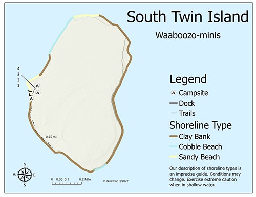
NPS Photo South Twin IslandWaaboozo-minis (South Twin) is located 18 miles from Bayfield.Acres: 360 Square Miles: 0.6 miles Length: 1.1 miles Width: 0.5 miles Miles of Shoreline: 2.9 miles Elevation above Lake: 48 feet The no primitive camping zone on South Twin is 0.75 miles of shoreline on the western side near the dock, and a 1/4 mile around the official campsites 1-3. The best spot for kayakers to access South Twin is a sandy beach on the north end of the island. The south end of the island is cobble beach and the remaining shoreline is clay banks that are not easily accessible by boat. 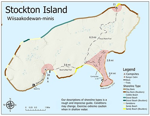
NPS Photo Stockton IslandWiisaakodewan-minis (Stockton Island) Quarry Bay is located 14 miles from Bayfield and Presque Isle Bay is located 16 miles from Bayfield.Acres: 10,054 Square Miles: 15.7 miles Length: 7.4 miles Width: 3.7 miles Miles of Shoreline: 22.7 miles Elevation above Lake: 198 feet Stockton Island is one of the largest Apostle Islands with the most official campsites and a diverse shoreline. The no primitive camping zones are a 1/4 mile around the group sites A, B, & 20 in Quarry Bay, a 1/4 miles around site 21 on the northeast side, and the entire tombolo shoreline including Presque Isle Bay and Julian Bay (campsites 1-19), and the ranger station. There are a few small sandy beaches along the island shore that are accessible by kayak including 1/2 mile directly south of site A in Quarry Bay near the Quarry Bay trailhead, and five small stretches anywhere from a 1/4 - 1/2 mile along the northwest side that are broken up by gravel beaches and clay banks with boulders. |
Last updated: June 24, 2025
