Hiking

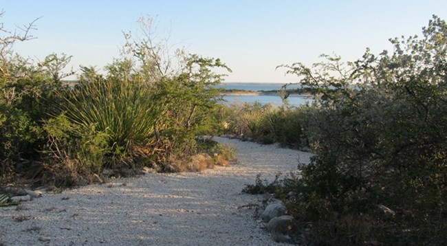
On Diablo East nature trail looking towards Lake Amistad.

NPS

Amistad National Recreation Area offers hikers a number of trails to explore, whether you are interested in just a short walk or a more ambitious hike.

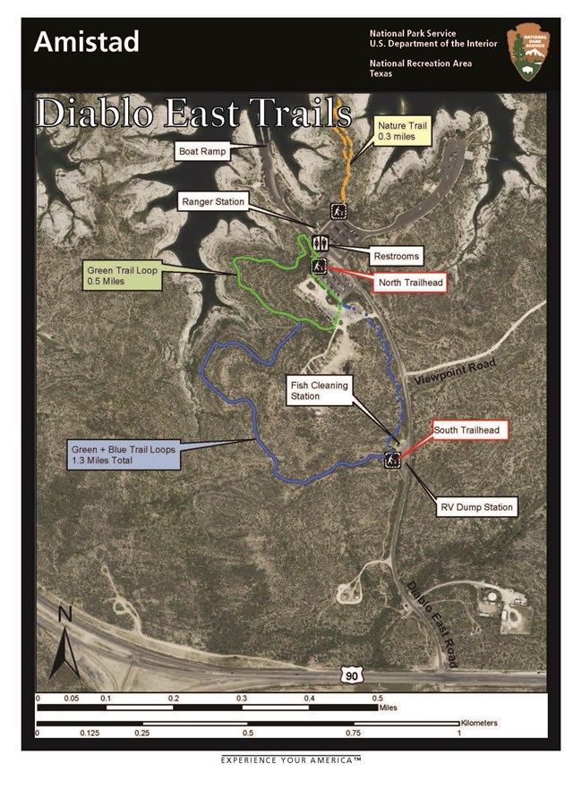
A short interpretive nature trail can be found at Diablo East. Here you will learn about a variety of plants and enjoy sweeping views of Lake Amistad. Print your copy of the Diablo East Trail Map.

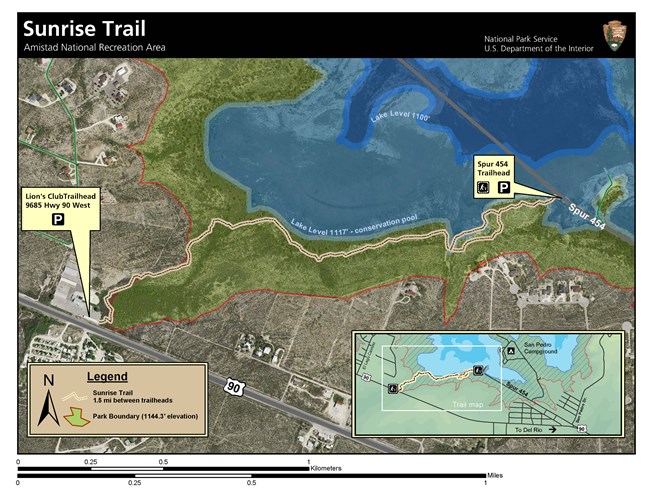
The Sunrise Trail is 1.5 miles long and connects from 9685 Hwy 90 West to Spur 454. Located on the old Brite Ranch, you will see a large variety of plants and birds while hiking. There are benches so you may sit and enjoy the sweeping views of the lake. Also available for printing is a copy of the Sunrise Trail Map.

At the Pecos, you will find a short interpretive nature trail along the Pecos River. Enjoy views of the Pecos River, its cliffs and a wide variety of plants.

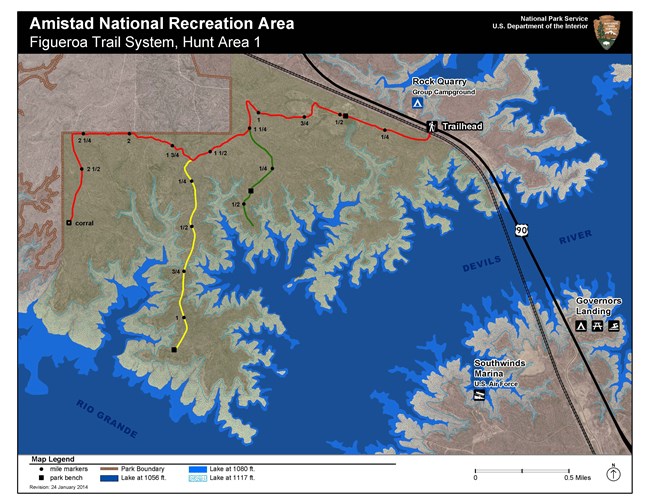
The Figueroa Trail is actually a series of trails that comprise the longest section in the recreation area. Located on the old Figueroa Ranch, these rolling trails will take you through desert and shrubland plants, while providing views of the lake and the dam. A printable Figueroa Trail Map is also available. CAUTION: Please note that the Figueroa Trail system is located within Hunt Area 1. Please use caution during hunting season (September,1 - February, 28).

Be sure to have a copy of Amistad NRA's Official Map and Guide, which shows the park's boundaries, since hiking on adjacent private land is not permitted. Text only descriptions of the maps are located at the bottom of this page.


Hiking Safety Tips

  • Always carry enough water (1 gallon per person per day).
  • Hike during cooler hours of the day.
  • Always use sunscreen and wear protective clothing.
  • The landscape is full of plants with thorns; wear heavy-soled hiking boots.
  • Watch out for venomous snakes. If you encounter a snake do not make any sudden movements. Stop, then slowly back away from it. Do not kill the snake. Snakes are protected by federal law, and play a very important part in the desert ecosystem.
  • If you plan to hike alone, always let somebody know where you are going and when you will return.
  • Take only pictures, leave only footprints. All things inside National Park Service boundaries, living and non-living, are protected by federal law. The removal of plants, animals, artifacts, rocks, etc. is prohibited.
 
mountain lion
The most recognizable feature of a mountain lion is its long tail, which measures about two-thirds the length of its body.

NPS

Mountain Lion Safety

Mountain lions are known to be in the area but are rarely seen. While an encounter is unlikely, it is always a good idea to be prepared and know how to react in case you have an encounter with an aggressive mountain lion.
  • Maintain eye contact, and never turn away from the lion.
  • Stand up straight, with arms above your head in order to appear larger. If children are hiking with you, pick them up and hold them.
  • Back away very slowly in case the lion is guarding a kill or her den.
  • If the lion approaches, throw rocks or sticks and yell at the animal.
  • If the lion does attack, fight back.


Text Only Version of Trail Maps

Sunrise Trail Map Description

The Sunrise Trail Map depicts the Sunrise Trail which runs from the Amistad Visitor Center to the old road, Spur 454. The map is an aerial satellite view of an area of approximately one square mile. Along the bottom of the map Highway 90 runs mostly east to west, and on the left or west side of the map is the park Visitor Center Trailhead. The trail starts here on the west side and runs north and east toward the Spur 454 Trailhead. It is represented by an orange line, and the trail is approximately 1.5 miles from the Visitor Center Trailhead to the Spur 454 Trailhead. The park boundary is shown on the map with a red line, and just outside the park boundary are several houses that overlook the lake. The map also shows where the lake shore would be at two different levels, 1117 feet and 1100 feet. At 1117 feet which is the lake “conservation pool” it would be near the trail. The map also has an inset in the lower right hand corner showing a wider view of the area to include San Pedro Campground which is just east of the Spur 454 Trailhead.

Diablo East Trail Map Description

The map shows a satellite view of the Diablo East day use area and surrounding land. It covers an area of approximately ¾ square miles. At the bottom of the map US Highway 90 runs east and west. Off of Highway 90 the Diablo East Road runs north and south from top to bottom on the map. Following the Diablo East Road north, the first public amenity is the RV dump station, located on the west side of the road. There is also a fish cleaning station and trailhead at this location. Continuing north on Diablo East Road , next is the Viewpoint Road which runs east and off of the map. Next while traveling north is a parking area (designated as the lower parking area below) located on the west side of the road. At the parking area is also a public restroom and trailhead. Across the road from this parking lot is another smaller parking area (designated as the upper parking area below) and the Park Law Enforcement ranger station. Following the road from this parking area is a small road that leads to another parking area and a marina. (*Please note that this marina is not open to public access and has no concession or rental activities.) The main Diablo East road continues north past the parking areas and dead ends at the area boat ramp.

Three trails are marked on the map: the Blue Trail Loop, Green Trail Loop, and the Nature Trail. The Blue Trail Loop is 1.3 miles, with its trailhead at the RV dump station. It loops north and west, briefly connects with the Green Trail Loop, runs through the south end of the lower parking area and back to the RV Dump Station. The Green Trail Loop trailhead is located near the public restrooms on the north end of the lower parking area. The loop runs west and south from here, briefly connects with the Blue Trail Loop and returns through the lower parking area. The Nature Trail (marked on the map with an orange line) begins on the north end of the upper parking area and does a small loop on a point of land near the lake shore. It is .3 miles in length.

Figueroa Trail System, Hunt Area 1 Map Description

This map is a graphic representation of the Figueroa Trail System and Hunt Area 1 at Amistad. It covers an area of approximately 7 square miles. The overall view of the map shows two points of land intersected by the lake, composed of the Rio Grande fork at the southwest corner of the map, and the Devil’s River fork running from southwest to the east side of the map. The smaller point of land in the southeast corner of the map shows US Highway 90 and railroad tracks running north, northwest and crossing the Devil’s River fork of the lake and then both continue northeast off the top of the map. Points of interest on this point of land include: Southwinds Airforce Marina on the west side of Highway 90 and Governors Landing day used area and campground on the east side of the road.

The second and larger point of land takes up the northwest corner of the map and includes the Figueroa trail system which is located in Hunt Area 1. The hunt area is represented with a dark shaded area and begins on the south side of the passing railroad track and continues south to the lake. The trailhead for starts off the south side of Highway 90 shortly after it crosses the Devil’s fork of the lake. The main branch of the trail (represented by a red line) heads west about 2 ¼ miles and then turns south for approximately another ½ mile ending at the corrals. The first branch off of the main trail (represented by a green line) heads south at the 1 ¼ mile mark for approximately ¾ mile, ending near the lake shore. The last branch (represented by a yellow line) heads south at about the 1 ½ mile mark for approximately 1 ¼ miles, ending near the lake shore.

Also represented on the map is the Rock Quarry group campground which is on the east side of Highway 90, across from the Figueroa trailhead. Along the trail system, park benches are located at the ½ mark of the main trail, near the ½ mile mark of the green branch, and at the end of the yellow branch. The park boundary is shown along the north and west side of Hunt Area 1, and color representations are presented for three lake levels: 1056, 1080, and 1117 feet.

Last updated: December 21, 2020

Park footer

Contact Info

Mailing Address:

10477 Highway 90 West
Del Rio, TX 78840

Phone:

(830) 775-7491

Contact Us