
NPS When describing glaciers in Wrangell St. Elias National Park and Preserve, superlatives are evident. Within park boundaries exists the nation's largest glacial system, with glaciers covering 35 percent of the parklands. In summer, these glaciers contribute a significant portion of the rivers' high runoff and heavy sediment load. During the winter, glacial melt reduces and many rivers run with clear water. Glaciers are the headwaters for many of the river systems that flow like arteries through the park. They are heavy with glacier silt and sediment, causing them to braid as one channel begins to fill with sediment forcing the water to switch to a new channel. Glaciers themselves are often referred to as rivers of ice. They flow down mountain valleys and, in the case of tidewater glaciers, into the sea. Notable Glaciers in Wrangell-St. Elias:


Hubbard GlacierThe Hubbard Glacier is North America's largest tidewater glacier.
Why Does the Hubbard Glacier Advance and Retreat? During the summer of 2002 the Hubbard Glacier near Yakutat pulsed forward, closing Russell Fiord from the sea. The massive ice dam that formed was later breached and washed out by water retained behind it, reconnecting the fiord to the ocean. Rather than being an event that took hundreds of years, this drama played out in the course of a couple of months. This short-term fluctuation was small, however, compared with the overall terminus advance that occurred over the last 100 years. This recent advance is in contrast with the behavior of most glaciers in Alaska and worldwide, which are retreating. Why? 
NPS / Neal Herbert Why does the Kennicott Glacier look so dirty?Many people are surprised by their first glimpse of the Kennicott Glacier. Instead of the clean white and blue ice they envisioned, they are confronted with a rough, rocky, brown moonscape. Is that really a glacier out there? It is indeed; the surface moraine of dirt and rocks is only a few inches to a few feet deep, while the ice underneath is still hundreds of feet thick. How did the glacier get so dirty? Although landslides and avalanches contribute, it all comes down to movement, melting and medial moraines. The Kennicott Glacier moves 26 miles from the high peaks of the Wrangells to the valley floor. Many glacial tributaries feed into this river of ice, each carrying its own load of debris as it carves its way downwards. These tributary debris loads form the medial moraines of the Kennicott Glacier. The rocks and dirt on these medial moraines affect the melting of the ice underneath. If less than 6 inches of debris cover the ice, the dark layer will transfer heat and accelerate melting. If the debris is more than 6 inches thick, it will instead insulate and protect the ice. As the glacier moves, the debris cover also moves, eventually spreading over the ice. The moraines merge just north of Kennecott, forming the surface moraine you see now. Even with its protective surface moraine, the Kennicott Glacier is melting fast. When the Kennecott Mines were at their peak in the early 1900's, the glacier towered over the mining camp, in some places even taller than the mill building. But it is deflating quickly and now we look down on the glacier, even at street level. One study showed that the Kennicott Glacier lost 115 to 330 feet (35 - 100 meters) in just 50 years, from 1957 to 2007. Depending on location, the Kennicott Glacier is currently losing 6 to 23 feet (2 - 7 meters) of ice a year, a dramatic example of a changing climate. Malaspina Glacier National Natural LandscapeTlingit: Sít' Tlein, meaning 'big glacier'Wrangell - St Elias National Park & Preserve 
NPS Malaspina is the colonial name for the glacier, in honor of Alessandro Malaspina, a Tuscan explorer in the service of the Spanish Navy, who visited the area in 1791. In 1874, W.H. Dall, of the U.S. National Geodetic Survey, bestowed the name "Malaspina Plateau". Originally, its indigenous name in Tlingit is Sít' Tlein, meaning 'big glacier'. Latitude: 59.971466064453125 Longitude: -140.52377319335938 Ongoing research (article series, nps website)Seeing & Exploring Glaciers Hikers should not attempt to cross glaciers without training and proper equipment, including crampons, ropes, and ice axes. Clean ice and even debris-covered moraines will turn slick and dangerous during or after a rain. Please discuss your plans with a park ranger before undertaking glacial travel or mountain peak ascents. Guides are available for these activities and can be used to gain experience. A great way to see the park's glaciers and icefields is from the air. There are a number of flightseeing operators that offer a variety of spectacular tours. The only way to see the Hubbard Glacier is to visit Yakutat, Alaska. You can see it by boat or by air. Several cruise ship companies include the Hubbard Glacier on their Alaska cruise itineraries. Glacier Ice Features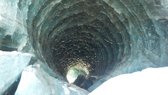
Glacier Ice Caves
Melting at the margin of a glacier may cause small caves to form, creating a tunnel between the ice and bedrock or sediment. 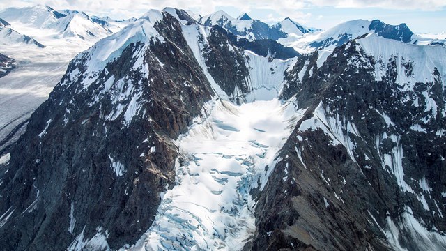
Ice Falls
Ice falls in a glacier are like water falls in a river and they form in steep sections of the glacier. 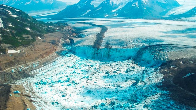
Jökulhlaups
Jökulhlaups (an Icelandic word pronounced yo-KOOL-lahp) are glacial outburst floods that occur when a glacial meltwater lake breaches. Additional Information...NPS Subjects: Investigate Glaciers - Explore glaciers through images, panoramas, video, sounds, and text. The Life of a Glacier by the National Snow and Ice Data Center. Glaciers in Alaska's National Parks by the National Park Service Alaska Regional Office. Additional Resources |
Last updated: January 29, 2024