Photo by Ken and Mary Campbell
The Hoh Rain Forest is located in the stretch of the Pacific Northwest rainforest which once spanned the Pacific coast from southeastern Alaska to the central coast of California. The Hoh is one of the finest remaining examples of temperate rainforest in the United States and is one of the park's most popular destinations. The Hoh lies on the west side of Olympic National Park, about a two-hour drive from Port Angeles and under an hour from Forks. The Hoh Rain Forest is accessed by the Upper Hoh Road, off of Highway 101 (directions). A general map and information regarding facilities, picnic areas, camping, and regulations can be found on the park's Hoh Rain Forest brochure. 
NPS Photo Places to Stay There are also places to stay just outside the park boundary, and in the town of Forks, less than a one-hour drive by car. Information about lodging can be found through the Forks Chamber of Commerce website. Recreation The area offers two short loop trails as well as an out-and-back trail through the forest near the Visitor Center.
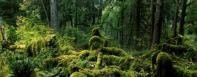
To get permits and more information on backpacking along the Hoh River Trail and throughout Olympic National Park, visit the Wilderness (Backcountry) Reservations page. Nearby Areas Imagine a climate that rains most of the year. Its average summer temperatures don’t reach above the mid 70s F or low 20s C. The undergrowth is dense and the canopy is thick, providing shade until an old growth giant falls. This is the life in a temperate rainforest. If you were an animal here, where would you live? If you were a plant, how might you survive? The flora and fauna of the Hoh are unique and abundant. So what might you see?
It is always exciting to see animals in our lush forests. It is common for visitors to spot large mammals like Roosevelt Elk, Black Bears, and River Otter. One may also spot signs of more elusive animals such as Bobcat and Mountain Lions that are more active at night. The overgrown forest floor provides the perfect habitat for animals like banana slugs , snails, rodents, snakes, and salamanders. Among the treetops, you may hear birds sing. We often see American Robins, Barred Owls, and Canada Grey Jays. The old growth provides a special habitat for the endangered Northern Spotted Owl, so remember to respect the home of these animals during your visit! The Hoh is home to some of North America’s giants. As you traverse the trails, you may feel miniscule in comparison to the Sitka Spruce, Red Cedar, Big Leaf Maple and Douglas Fir that thrive here. Check out the Tree ID guide to navigate the forest and know which trees you’re hiking with! These tall trees darken the ecosystem below them, giving much loved shade to the hundreds of mosses and ferns below. A skylight only opens once one of these giants collapses, providing not only sunlight, but nutrition and new life to the forest that may grow upon its fallen trunk. These nursery logs can be seen throughout the forest in varying stages of decay. Do you see the new growth just sprouting? Can you see evidence from an oddly straight line of now-towering trees, perhaps still with space below their roots where a nursery log once gave nutrients and protection? This forest is teeming with life around every root. The variety of greens will thrill the eye as you hike through natural history. 
NPS staff 
NPS Staff Visit the Hoh Rain Forest Photo Gallery on Flickr
|

Last updated: March 18, 2025