
NPS Collection Loading weather forecast... Parking and HoursParking Lot Lake View
The parking lot of Lake View is paved and accessible. Facilities and a shelter are also accessible. There are stairs down to the beach.
7 Day Motorcycle Fee Per motorcycle (valid for 1-7 days from date of purchase). Cost: $20.00 7-Day Park Entrance Pass - Family-Size Vehicle Pass Per private family-sized vehicle (valid for 1-7 days from date of purchase). Cost: $25.00 7-Day Per Person Entrance Pass (Organized, non-commercial groups) Visitors 16 years of age or older who enter on foot, bicycle, boat, or as part of an organized group not involved in a commercial tour. Cost: $15.00 Indiana Dunes National Park Annual Pass This pass provides entry for the pass owner(s) and passengers in a family-sized vehicle. This pass only works at the Indiana Dunes National Park and is not accepted at the Indiana Dunes State Park. Cost: $45.00 Annual Pass (Interagency) Interagency passes like America the Beautiful and The National Parks and Federal Recreational Lands Pass Series. Cost: $80.00 Annual Military Pass (Interagency) Active, Veteran or Gold Star Family. Cost: $0.00 Annual Fourth Grade Pass for US Students in Fourth Grade Every Kid in a Park (EKIP), an initiative to encourage 4th grade children and their families to enjoy our country’s national parks and public lands, for FREE. Cost: $0.00 Annual Senior Pass (Interagency) The senior pass is available for citizens above the age of 62. Cost: $20.00 Lifetime Senior Pass (Interagency) A one-time fee for senior citizens above the age of 62. Cost: $80.00 Lifetime Access Pass The Access Pass is a free, lifetime pass available to United States citizens or permanent residents, regardless of age, that have a permanent disability. Cost: $0.00 Amenities
Image Gallery
Getting There Lake View Beach Parking Lot
1/8 mile west of the intersection of Lake Front Drive and Broadway Street, Beverly Shores, IN 46301.
Do NOT park in the Town of Beverly Shores' beach parking lot, which is located just to the east of the Lake View lot.
Need to Know
Safety
Accessibility
Visitor Activities
Beach SafetyKnow Before You Go!
Rip Currents:Be on the lookout this summer for rip currents on Lake Michigan. Before your next visit to the beach, learn how to spot a rip current and what to do if you get caught in one. Always check the local beach forecast for any warnings, and exercise caution. IF CAUGHT IN A RIP CURRENT♦ Don't fight the current SAFETY♦ Know how to swim 
Drowning? Flip, Float, and Follow“Flip, Float, and Follow,” is a campaign and drowning survival technique by Great Lakes Surf Rescue Project to help people remember how to successfully escape a variety of drowning accidents in the Great Lakes such as rip currents, long-shore currents, and structural currents. 1️⃣FLIP: Flip over onto your back and float. 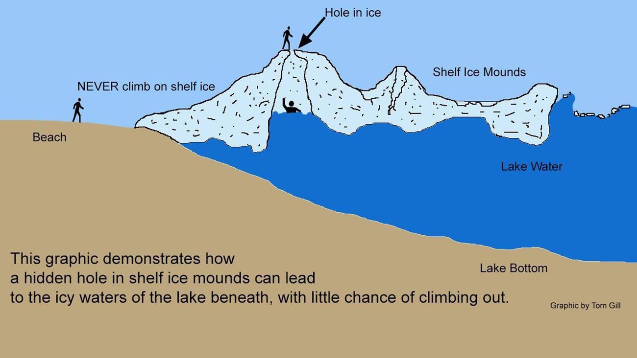
The Dangers of Shelf Ice
Stay off the shelf ice! Despite its unusual beauty, don't risk your life. Enjoy the view of the shelf ice—from a distance! |
Last updated: September 13, 2023