What's So Special about Wrangell-St. Elias

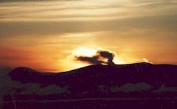
Mount Wrangell, 14,163', is an active volcano. A steam plume is often visible near the summit. Photo by N. Hannan

Wrangell-St. Elias National Park and Preserve is incredible. In isolation from the rest of the world, this swath of land is simply massive. It is the largest national park in the United States, with a size equal to six Yellowstone National Parks, and boasts many peaks and glaciers. Follow any braided river or stream to its source and you will find either a receding, advancing, or tidewater glacier. The park lets you sample representative Alaska wildlife as well as historic mining sites. Hike its mountains, float its rivers, ski its glaciers, or fly over its landscapes and you will witness living geology. A feeling of wonder is understandable; after all, you might be the first to see such sights.

The peaks' sheer numbers quickly quell your urge to learn their names. Settle back and appreciate their beauty, mass, and rugged grandeur. Because roads are few, many travelers will not enter the park itself; however, major peaks – Blackburn, Sanford, Drum, and Wrangell – are clearly seen from nearby highways. If you position yourself in any one spot, you’ll witness the sun, clouds, and storms play hide and seek with single peaks or ridges. Many of our visitors watch the weather change by the minute. Four major mountain ranges meet in the park, which include nine of the 16 highest peaks in the United States. The Wrangell Mountains huddle in the northern interior. The Chugach Mountain range guards the southern coast. The St. Elias Mountains rise abruptly from the Gulf of Alaska to thrust northward towards the Wrangell Mountains, passing the Chugach Range along the way. The eastern end of the Alaska Mountain Range – mapped as the Nutzotin and Mentasta mountains – forms part of the preserve's northern boundary.

The Wrangell Mountains are volcanic in origin, but only Mount Wrangell remains active (last reported eruption was in the 1900s), with vents of steam near its summit. With adjoining Kluane National Park in Canada, all these ranges form North America’s premier mountain wilderness. Covered year-round with snow, the high-country stands cloaked with icefields and glaciers. Sitting near the coast, North America’s largest subpolar icefield, named the Bagley Icefield, creates four giant glaciers: Tana Glacier, Miles Glacier, Hubbard Glacier, and Guyot Glacier.

 
Hubbard Glacier
 

The Malaspina Glacier flows out of the St. Elias Range between Icy and Yakutat bays in a mass larger than the state of Rhode Island. So much glacial silt rides it that plants and trees take hold on the glacier’s extremities and grow to maturity, only to topple over the edge when it melts. Flowing from glaciers are multitudes of meandering rivers and braided streams. The largest one is the Copper River, forming the park’s western boundary. It rises in the Wrangell Mountains and empties into the Gulf of Alaska in the Chugach National Forest.


In the early 1900s, the Kennecott Mining Co. transported copper from its mines near McCarthy by railroad along the Chitina and Copper rivers to ships at Cordova. Ore was extracted from these productive mines between 1911 and 1938 and lured many people to the area. Gold was extracted from the Nabesna area then too. Mining still takes place on private lands in the park, and evidence of earlier mining includes ruins of the Kennecott mines, now listed on the National Register of Historic Places. In mining's heyday, Alaska Native communities expanded, and several new towns sprang up. Copper Center, Chitina, Gulkana, and Chistochina are among some of the old Athabascan settlements. The town of Yakutat is a traditional Tlingit fishing village.
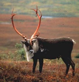
 
Caribou

While vegetation may appear sparse, especially in the interior, the park is home to a variety of plants and wildlife. Mountain slopes have a diversity of plants, dwarf shrubs, and grasses where Dall sheep and mountain goats patrol the craggy peaks. Interior and coastal spruce forests are home to shrubs, such as blueberry and prickly rose. Caribou feed on lichens and sedges on the slopes of the Wrangell Mountains. Moose browse in the sloughs and bogs of the forested lowlands, while bears roam throughout the park. Many rivers, streams, and lakes provide spawning grounds for salmon and other fish. The Copper River drainage marks major flyways for migratory birds and provides nesting sites for trumpeter swans. Coastal areas are habitat for marine mammals, including sea lions and harbor seals.


Park Superlatives:

  • Largest national park in the United States.
  • Largest wilderness area in the National Wilderness Preservation System.
  • Designated as a World Heritage Site with Glacier Bay National Park & Preserve, the Canadian neighbors Kluane National Park & Reserve and Tatshenshini-Alsek Provincial Park. (Making this the world's largest international protected wilderness.)
  • Four major mountain ranges: Wrangell, St. Elias, Chugach, and the eastern part of the Alaska Range.
  • Mt. St. Elias, at 18,008 feet (5.5km), is the second highest peak in the United States.
  • Nine of the 16 highest peaks in the United States.
  • Mt. Wrangell, at 14,163 feet (4.3km), is one of the largest active volcanoes in North America.
  • The Nabesna Glacier, at approximately 53 miles (85km), is the longest valley glacier in North America and the world's longest interior valley glacier.
  • The Malaspina Glacier, larger than the state of Rhode Island, is the largest non-polar piedmont glacier in North America.
  • The Hubbard Glacier is one of the largest and most active tidewater glaciers in North America.

These facts are not the end of the superlatives! Explore the park and discover others for yourself.

Last updated: July 22, 2025

Park footer

Contact Info

Mailing Address:

Wrangell-St. Elias National Park & Preserve
PO Box 439
Mile 106.8 Richardson Highway

Copper Center, AK 99573

Phone:

907 822-5234

Contact Us

Tools