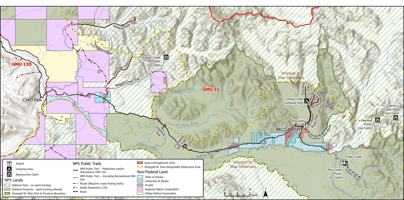
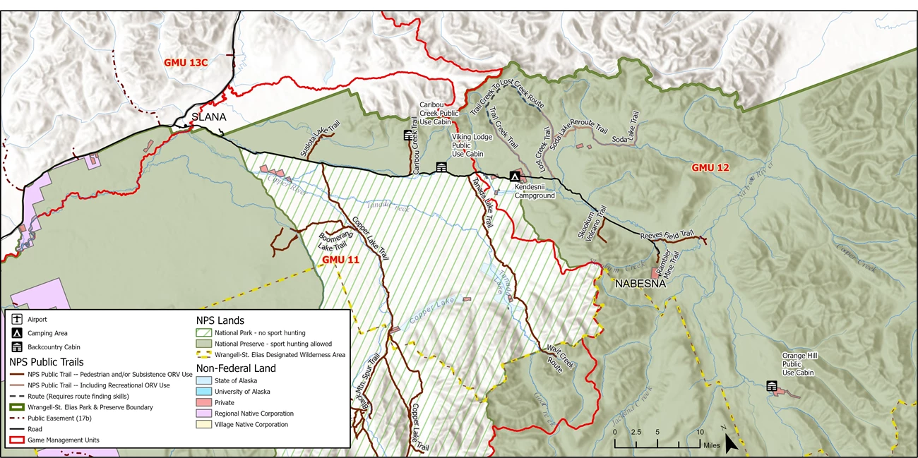
ORV permits are recommended for subsistence users. Subsistence users are those individuals who reside within a local resident zone community for the park, have a customary and traditional use determination from the Federal Subsistence Board for resources in the intended harvest area, or both. Find out if you qualify. Users may apply for FREE permits in-person at the Slana Ranger Station or online.
Updates for 2026:
- Self-registration permits are no longer available at the Nugget Creek trailhead.
- ORV permits are now available through an online application process.
Online Application Process:
The ORV permit application and permit form, must be emailed to wrst_permits@nps.gov. The approved special use permit will be sent back to the ORV permit holder. Allow a minimum of 2-3 business days for processing time for emailed permit applications. The ORV operator must have a copy (hard or digital) of the signed and approved permit on them at all times.
10-933 Subsistence Application for Vehicle Special Use Permit (fillable pdf 1,350 KB)
Subsistence ORV Users
Qualified, local, rural residents may use ORVs to engage in subsistence activities on park, preserve, and in designated wilderness. To minimize resource damage, it is recommended that subsistence ORV users travel on established trails and dry river beds. ORV Permits are issued to document the type and amount of use on trails, to identify the location of users in the event of an emergency, and to ensure users are aware of the restrictions governing the use of ORVs on park lands.
To determine federal subsistence eligibility, please present a driver’s license or state ID to demonstrate your Alaska residency, as well as, a voter registration card, a recent utility bill listing your physical address, or a mortgage or rental receipt to verify your local physical address. Please bring two of the documents (one for Alaska residency and one for local physical address) described above with you when you come for your appointment.
Trails Open to Subsistence Use - permit recommended
Nabesna Road
Suslota Lake Trail
Trailhead: Parking at Milepost 11.2 Nabesna Road, Trailhead at Milepost 11 Nabesna Road
Distance/Time: Approximately 8 miles / 4 - 6 hours by ORV.
Land Status: National PRESERVE
Trail Conditions: Travel is difficult due to muskeg, mud bogs, standing water and tussocks. Conditions vary with seasonal rains and amount of use, but are generally poor and wet.
Ranger Tips: This trail is not recommended for hiking. After approximately 8 miles the trail crosses out of the National Preserve and on to State of Alaska land. Suslota Lake is outside of the Park boundary on State land. There are a number of privately owned cabins around the lake. Heaviest annual use is during mid-August through mid-September.
Copper Lake Trail
Trailhead: Milepost 12.2 Nabesna Road
Distance/Time: 14 miles to the Wilderness Boundary. 4-6 hours by ORV
Land Status: National PARK
Trail Condition: Varies with seasonal rains and amount of use. The first 6 miles are generally over dry dirt. The remainder of the trail may be very wet with numerous mud bogs so travel can be difficult.
Private Lands: Private lands and structures are located at the western and eastern ends of Copper Lake.
Special Conditions: Sockeye Salmon migrate up Tanada Creek to spawn in Tanada Lake. You must cross the creek at the established bridge crossing ONLY.
Ranger Tips: The first 2.5 miles of the trail is suitable for day hikers.
Note: For trails in the Black Mountain area and the southern portions of the Tanada Lake Trail (formally called the Final Environmental Impact Statement Nabesna Off-Road Vehicle Management Plan (FEIS) Wilderness Area), subsistence ORV users must stay on trails or, for the purpose of game retrieval only, within identified trail corridors (1/2 mile on either side of the trail). ORV use outside of these designated trail corridors in the FEIS Wilderness Area is prohibited. These trails, trail corridors, and the boundaries of the FEIS Wilderness Area (map) are identified on the map.
Caribou Creek Trail
Trailhead: Parking at Milepost 18.9 Nabesna Road, Trailhead at Milepost 19.2 Nabesna Road
Distance/Time: 3.5 miles / 1 - 2 hours by ORV, 3-4 hours hiking
Land Status: National PRESERVE
Trail Conditions: Conditions vary with seasonal rains and amount of use. The trail surface is dirt and rocky streambeds. Creek crossings can be hazardous when water levels are high. The first portion of the trail is easy but becomes more difficult because of several stream crossings and elevation gain.
Ranger Tips: Recommended for hiking. Caribou Creek trail offers outstanding views of the Wrangell Mountains and the Copper River Valley as well as access to hiking in the Mentasta Mountains.
Tanada Lake Trail
Trailhead: Milepost 24.5 Nabesna Road
Distance/Time: 15 miles / 8 - 10 hours by ORV to the Preserve Wilderness Boundary.
Land Status: National PARK
Trail Condition: Travel is generally extremely difficult due to deep mud bogs and tussocks. Drainage is poor and conditions are worsened after rain and heavy use.
Ranger Tips: Not recommended for hikers, however, some hikers do use this trail to access Sheep Lake and Grizzly Lake. Poor trail conditions make this a difficult hike. Hikers generally allow 5 to 7 days for this trip.
Note: For trails in the Black Mountain area and the southern portions of the Tanada Lake Trail (formally called the Final Environmental Impact Statement Nabesna Off-Road Vehicle Management Plan (FEIS) Wilderness Area), subsistence ORV users must stay on trails or, for the purpose of game retrieval only, within identified trail corridors (1/2 mile on either side of the trail). ORV use outside of these designated trail corridors in the FEIS Wilderness Area is prohibited. These trails, trail corridors, and the boundaries of the FEIS Wilderness Area (map) are identified on the map.
Reeve's Field Trail
Trailhead: Milepost 40.2 Nabesna Road
Distance/Time: 4.2 miles / 3 - 4 hours by ORV.
Land Status: National PRESERVE
Trail Conditions: Travel is difficult due to mud bogs and tussocks. Trail surface is dirt and corduroy improvements for the first 2 miles, with tussocks and mud bogs for most of the remainder of the trail. There are two creek crossings that can be hazardous. Trail users should stay alert to changing conditions and rising water levels.
Private Lands: There are two private properties located adjacent to the Reeve Field trail near the Nabesna River. Private property begins shortly after the second Jack Creek crossing. A fifty foot easement is provided for trail users -- PLEASE STAY ON THE TRAIL.
Ranger Tips: The first mile of the trail is an easy hike to Jack Creek. There are two creek crossings. Hikers can continue up stream as far as the confluence with Jacksina Creek. Use caution before attempting to cross the Nabesna River or Jacksina Creek.
Trail Creek Trail
Trailhead: Milepost 29.8 Nabesna Road
Distance/Time: Approximately 5 miles / 2 –3 hours by ORV
Land Status: National PRESERVE
Trail Condition: Gravel stream bed. Rain and snow melt can cause dramatic increases in water levels. High water in Trail Creek can make travel hazardous. Stay alert to changing weather conditions.
Ranger Tips: Hikers can continue north up Trail Creek to a pass and cross over to the Lost Creek drainage. Follow Lost Creek back to Nabesna Road to create a loop trip.
Lost Creek Trail
Trailhead: Milepost 31.2 Nabesna Road
Distance/Time: Approximately 5 miles. 3 miles to Soda Lake Trailhead. 2-3 hours by ORV
Land Status: National PRESERVE
Trail Condition: Gravel stream bed and packed dirt. The trail follows the Lost Creek stream bed and frequently enters the forest adjacent to the creek. Rain and snowmelt can cause dramatic increases in water levels. High water in Lost Creek can make travel hazardous.
Ranger Tips: Hikers can reverse the Trail Creek-Lost Creek loop and start at Lost Creek.
Soda Lake Trail
Trailhead: Mile 3 of the Lost Creek Trail (Park at the Lost Creek Trailhead)
Distance/Time: 12 miles to Soda Creek, 2.5 additional miles to Soda Lake. 4-5 hours by ORV
Land Status: National PRESERVE
Trail Condition: Varies with seasonal rains and amount of use. The first 3 miles are over hard packed ground.
Route: Trail begins at approximately mile 3 of the Lost Creek Trail. (After 2 miles you will see an old trail to the right. Do not take this trail, as the main trail has been re-routed and will veer off in another mile. The old trail is closed.) The trail heads east after leaving Lost Creek, along the Platinum Creek drainage. When reaching the confluence of Platinum and Soda Creeks the trail turns north and follows the Soda Creek streambed, to Soda Lake approximately 1.5 miles further.
Private Lands: There is private land located on the old trail to Big Grayling Lake.
Ranger Tips: Good for hiking. Allow several days to explore the Mentasta Mountains and Soda Lake.
McCarthy Road
Nugget Creek Trail
Trailhead: The trailhead is located on the Kotsina Road. The Kotsina road turn-off is located at mile 14.5 on the McCarthy Road, on the north side of the road. After 2.5 miles, the trailhead is on the right. The best opportunity for parking is to go another 1.4 miles up the Kotsina road to the Dixie Pass trailhead. Parking at the Nugget Creek trailhead requires a permit from Chitina Native Corporation.
Distance/Time: Approximately 15 miles one way. 3 - 4 hours by ORV or 5 –6 hours hiking on foot.
Land Status: The first portion (approximately ½ mile) of the trail is on an easement that allows passage through Chitina Native Corporation private lands. Easements are for passage through to public lands - not for hunting, parking, or camping. The remainder of the trail is on National Park lands.
Trail Condition: The first ½ mile past the easement traverses wetlands. The NPS has made improvements to this section, but some mud/muck holes may still be encountered. Beyond this segment, the trail is in good condition.
Special Conditions: Because the trail is within national park (as opposed to national preserve), no sport hunting is permitted.
Kotsina Trail (Easement)
Trailhead: The trailhead is located on the Kotsina Road. The Kotsina road turn-off is located at mile 14.5 on the McCarthy Road, on the north side of the road. The Dixie Pass trailhead serves as the best trailhead for the Kotsina trail. The Dixie Pass trailhead is 3.9 miles up the Kotsina road.
Distance/Time: Approximately 20 miles along an easement to get to national park lands.
*Land Status: This trail is an easement through lands owned by Ahtna, Inc. and Chitina Native Corporation. Easements are for passage through to public lands - not for hunting, parking, or camping. Allowable uses on this easement include foot, ORV, four-wheel drive, and automobiles. However, the trail is NOT maintained for 4-wheel drives or automobiles.
Trail Condition: Vary from year to year, but includes brushy segments, wetlands, and challenging creek crossings.
*Special Conditions: The Kotsina trail is an easement that runs through private land. Because we don't have authority over the easement, we do not issue recreational ORV permits for this part of the trail (approx 20 miles). Once the trail reaches NPS park lands it continues into designated wilderness. All recreational ORV users must park their vehicles at the NPS boundary and continue on foot. Recreational ORV use and sport hunting are prohibited on NPS managed lands accessed by the Kotsina easement.


