Last updated: July 23, 2026
Thing to Do
Hike Norumbega Mountain Loop
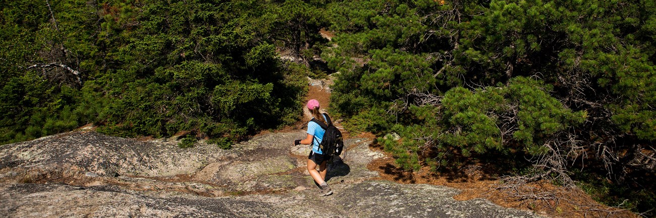
The Norumbega Mountain Loop features a steep hike up to the summit of Norumbega Mountain, then a gradual descent in the forest before hiking along the western shore of Lower Hadlock Pond. Portions of hike are on boardwalks since the trail goes over boggy areas.
- Distance: 3.2 miles round trip
- Terrain: The trail is rocky with uneven footing. Short, steep granite sections throughout. Some boardwalk sections along the pond's edge.
Hike Description
-
The Norumbega Loop starts on the northern end of the parking area. Follow signs for the Goat Trail.
-
The Goat Trail quickly ascends a steep section with granite boulders It joins with the Norumbega Mountain Trail along the ridge, and directly to the left of the signposts is the true summit of Norumbega Mountain at 852 ft.
-
The trail descends gradually through a forested area with some views of Somes Sound.
-
At the bottom, it reaches Lower Hadlock Pond and turns left on the Hadlock Pond Trail along the shoreline. The trail has some rooted sections and boardwalks over boggy areas before reaching a small waterfall where water flows from Upper Hadlock to Lower Hadlock Pond.
-
At the junction, take the Norumbega Connector to lead back to the parking area.
-
For a longer hike, add .4 miles by following the Hadlock Ponds Trail around Upper Hadlock Pond and Hadlock Brook Trail back to the highway.
-
Details
Duration
2-3 Hours
This hike is 3.2 miles roundtrip. Duration, or how long a hike takes, depends on your pace, how frequently you stop, and the terrain. For an average pace, this hike takes 2-3 hours.
Activity
Hiking
Age(s)
All ages, but not recommended for small children due to steep sections.
Pets Allowed
Yes with Restrictions
Dogs must be on a leash no longer than 6 feet. It is not recommended for pets, since there are many steep sections. No swimming allowed in Lower Hadlock Pond (public water supply).
Activity Fee
No
Although this activity is free, a park entrance pass is required for all areas of the park year round.
Location
Norumbega Mountain
The Trailhead: Where to Begin
-
Norumbega Mountain Parking Area (unmarked pull off after Parking Mountain Parking Lot
Getting to the Trailhead
- By car: After reaching Mount Desert Island on ME Route 3, stay to the right to follow ME Route 102. At the stop light turn left following ME Route 198 towards Northeast Harbor. (From Bar Harbor, follow ME Route 233 to reach ME Route 198.) Park at first unmarked pull off on the right south of Parkman Mountain parking lot. The trailhead is located on the north side of the pull off
- By bus: Take the Island Explorer (mid-June to October) to Parkman Mountain. Check bus schedules for times and routes.
Reservations
No
Season
Year Round
Time of Day
Day, Dawn, Dusk
Accessibility Information
Norumbega Mountain Loop is not accessible. The trails have uneven footing, short, steep sections that require some scrambling, and some narrow boardwalks.
There are no accessible restrooms at the trailhead.
There are no accessible restrooms at the trailhead.

Trail Safety Tips
- Check trail elevation profile before hiking.
- Bring a map, water, snacks, compass, and extra layers for unpredictable changes in weather.
- Reduce the chance of picking up ticks by staying in the center of the trail, and not stepping on soils and away from brush.
- Always do a tick check after visiting the park.
- Closed-toe, good traction shoes recommended because most trail surfaces are very unlevel.