Last updated: July 28, 2025
Thing to Do
Hike Gorge/Cadillac Mountain North Ridge Loop with Island Explorer Bus
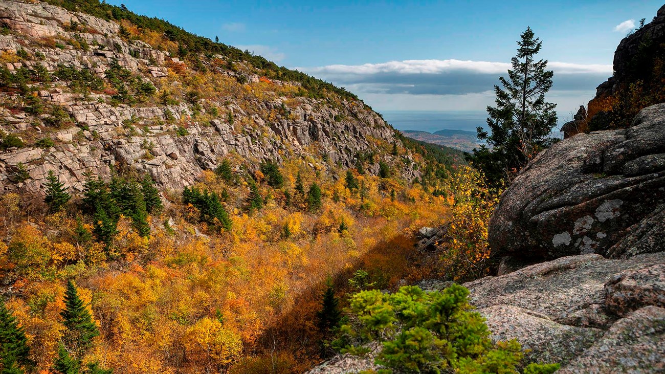
Photo be Ashley L. Conti, Friends of Acadia
This is a great option for hiking to the summit of Cadillac Mountain. The Gorge Path is mostly shaded and is perfect for hot summer days. It follows Kebo Brook which cuts deeply through the granite bedrock with views of steep canyons walls from the gorge below. The final portion of the path ascends a steep rock face and gives hikers vistas of Dorr Mountain, Frenchman Bay, the Atlantic Ocean, as well the deeply cut gorge itself. The summit of Cadillac Mountain provides a 360-degree view out over Mount Desert Island, its multiple peaks, the surrounding islands, and the ocean beyond.
If interested in hiking a loop trail instead of an out-and-back, the Gorge Path/North Ridge Trail combination is a good choice. The ascent is mostly shaded so it is perfect for hot summer days. Starting with the Kebo Brook Trail, it wanders through a forest of maple, oak, beech, and birch. As the Gorge Path climbs, it follows a portion of Kebo Brook which cuts deeply in the granite bed rock between two peaks, Dorr Mountain and Cadillac Mountain. Great views of the walls of the gorge rise from the trail lined with birch and spruce trees. The final .4-mile ascent changes dramatically to a steep rock scramble of over large granite boulders while offering fine views of Dorr Mountain, Frenchman Bay, the Atlantic Ocean, and the gorge below.
The hike down the North Ridge Trail, is more gradual over exposed granite with views to the north, west, and Frenchman Bay with the porcupine islands. Hiking this peak with use of the Island Explorer Bus offers hikers a bus-stop-only starting point for a moderate to strenuous hike.
This is a great option for hiking to the summit of Cadillac Mountain. It follows Kebo Brook which cuts deeply through the granite bedrock with views of steep canyons walls from the gorge below. The final portion of the path ascends a steep rock face and gives hikers vistas of Dorr Mountain, Frenchman Bay, the Atlantic Ocean, as well the deeply cut gorge itself. The summit of Cadillac Mountain provides a 360-degree view out over Mount Desert Island, its multiple peaks, the surrounding islands, and the ocean beyond.
Details
Duration
2-4 Hours
Because the trail offers multiple places to stop, rest, and to take in the views, the duration of the hike can vary widely. The hike is 5.2 miles with an ascent of 1,086 feet.
Activity
Front-Country Hiking
Hiking: The Gorge Path/North Ridge loop covers a distance of 5.2 miles and climbs 1,086 feet.
Cross the Park Loop Road to the trailhead and take the Kebo Brook Trail. At .3 miles it goes past the North Ridge Trail which enters from the right. This is where you will be coming from at the end of the loop. Go past that intersection as the trail descends for .4 miles to the Gorge Path with an 8 - 9% grade. Turn right and continue for .3 mile to where the trail passes under the Park Loop Road bridge, turn right after the bridge.
The trail is relatively flat the first .4 miles and then steadily begins to climb. At .8 the Hemlock Trail enters from the left, which leads to the Sieur de Monts area. Continue straight. Now the climbing really begins! As the gorge narrows, the trail ascends from a 9% to a 29% grade for the next mile with multiple stream crossing and stone stairs to help you on your way.
After a final ascent of stone stairs, the path levels out at the saddle between Dorr Mountain to the east and Cadillac Mountain to the west. Soon after, at 1.8 miles, the Cadillac-Dorr Mountain Connector intersects with the trail from the left. The trail straight ahead is called the A. Murray Young Path which descends the other side of the saddle. Take the Gorge Path which makes a right turn towards the summit of Cadillac. This is a good place to take a water break before the final and steepest part of the trail!
Most of the last .4 miles is an exposed steep rock face where it is necessary to scramble using both hands and feet as you ascend. Keep an eye out for the blue blazes and the cairns to find the way. The climb will be worth it, you will be rewarded with views of the gorge below, Dorr Mountain to the east, and vistas of the Atlantic Ocean to the south and Frenchmen Bay to the north.
As the climb ends, the trail crosses an easy loop around the summit with views that expand to all directions of the island and the ocean beyond. To reach the actual summit of Cadillac look for the trailhead for the South Ridge trailhead on the south side of the parking loop. Walk about 100 feet south past the trailhead sign down the South Ridge Trail and take a hard right. Just behind the gift shop you will see a cluster of granite rocks with the summit marker on top.
To reach the North Ridge trailhead return to the parking loop and cross to its north side. Keep an eye out for the blue blazes and the historic Bate’s Cairns as you descend. The 2.2-mile hike down is more gradual with sweeping views to the north, west, and of Frenchman Bay along the way. It runs alongside the Road leading up to Cadillac Summit with a short trail leading to it with more opportunities for views. Continue down the trail until it reaches the Kebo Brook Trail and turn left. The trail ends after .3 miles at the Park Loop Road and the bus stop for the #4 or #5 which will take you back to the Hull’s Cove Visitor Center Parking Area.
Pets Allowed
Yes
Pets are allowed on a leash. (6-feet or shorter) However, the ascent from the Gorge Path to the summit may be challenging from most dogs because it requires scrambling over boulders large on a steep rock face.
Activity Fee
No
A park pass is required for any activity in the park. The pass should be left displayed in personal vehicles. Visitors are not required to carry it with them and will not be asked to show it while on the trail or riding the bus.
Location
The Gorge Path and the Cadillac North Ridge Trail
Hiking: The loop begins and ends on the Park Loop Road north of Cadillac Mountain at the Kebo Brook Trail Head and the North Ridge Bus Stop. The Gorge Path/North Ridge loop covers a distance of 5.2 miles and climbs 1,086 feet.
Cross the Park Loop Road to the trailhead and take the Kebo Brook Trail. At .3 miles it goes past the North Ridge Trail which enters from the right. This is where you will be coming from at the end of the loop. Go past that intersection as the trail descends for .4 miles to the Gorge Path with an 8 - 9% grade. Turn right and continue for .3 mile to where the trail passes under the Park Loop Road bridge, turn right after the bridge.
The trail is relatively flat the first .4 miles and then steadily begins to climb. At .8 the Hemlock Trail enters from the left, which leads to the Sieur de Monts area. Continue straight. Now the climbing really begins! As the gorge narrows, the trail ascends from a 9% to a 29% grade for the next mile with multiple stream crossing and stone stairs to help you on your way.
After a final ascent of stone stairs, the path levels out at the saddle between Dorr Mountain to the east and Cadillac Mountain to the west. Soon after, at 1.8 miles, the Cadillac-Dorr Mountain Connector intersects with the trail from the left. The trail straight ahead is called the A. Murray Young Path which descends the other side of the saddle. Take the Gorge Path which makes a right turn towards the summit of Cadillac. This is a good place to take a water break before the final and steepest part of the trail!
Most of the last .4 miles is an exposed steep rock face where it is necessary to scramble using both hands and feet as you ascend. Keep an eye out for the blue blazes and the cairns to find the way. The climb will be worth it, you will be rewarded with views of the gorge below, Dorr Mountain to the east, and vistas of the Atlantic Ocean to the south and Frenchmen Bay to the north.
As the climb ends, the trail crosses an easy loop around the summit with views that expand to all directions of the island and the ocean beyond. To reach the actual summit of Cadillac look for the trailhead for the South Ridge trailhead on the south side of the parking loop. Walk about 100 feet south past the trailhead sign down the South Ridge Trail and take a hard right. Just behind the gift shop you will see a cluster of granite rocks with the summit marker on top.
To reach the North Ridge trailhead return to the parking loop and cross to its north side. Keep an eye out for the blue blazes and the historic Bate’s Cairns as you descend. The 2.2-mile hike down is more gradual with sweeping views to the north, west, and of Frenchman Bay along the way. It runs alongside the Road leading up to Cadillac Summit with a short trail leading to it with more opportunities for views. Continue down the trail until it reaches the Kebo Brook Trail and turn left. The trail ends after .3 miles at the Park Loop Road and the bus stop for the #4 or #5 which will take you back to the Hull’s Cove Visitor Center Parking Area.
BUS INFORMATION : Park at the Hull’s Cove Visitor Center parking area. The bus stops are located to the right of the Pavilion at the bottom of the stairs leading to the Visitor Center.
Departure: Take the #5 Jordan Pond Bus or the #4 Loop Road Bus to the first stop, North Ridge Trail.
Return: You have the option of taking the either the #5 Jordan Pond bus or the #4 Loop Road bus back to the visitor center parking area.
Note: Island Explorer bus operations start mid-June and continue till mid-October. Schedules are subject to change. Refer to the website for latest information. www.exploreacadia.com
Reservations
No
Season
Spring, Summer, Fall
Time of Day
Day, Dawn, Dusk
Day, Dusk, Dawn. The Park and trails are open 24 hours a day, but the Island Explorer shuttle begins service to Sand beach at 9 am and ends service between 5:20 and 5:40 pm.
Accessibility Information
This loop is not accessible. The Gorge Path/North Ridge Loop has exposed roots and rocks, steep stone stairs, and requires scrambling over large boulders.
Tags:
acadia national park