Last updated: July 23, 2026
Thing to Do
Hike Giant Slide Loop
This is a challenging "lollipop" hike up a rugged ravine to excellent views atop Sargent Mountain, Gilmore Peak, and Parkman Mountain. As this trail begins on private land, please respect owner privacy and protect fragile moss and lichen by staying on the marked trail.
- Distance: 5.7 miles round trip
- Terrain: Forested trail, rocky granite slopes, rock slide and boulder fields, granite exposed summits
Hike Description
-
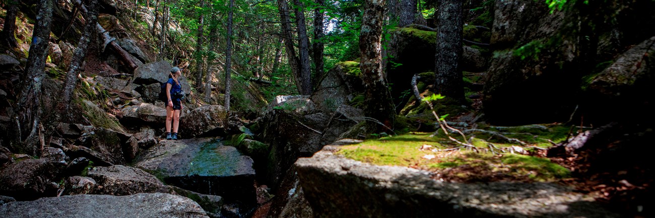
The Giant Slide Trail begins as a very gradual ascent through private land. Please respect private land ownership and protect the mossy forest.
-
After crossing the carriage road, the trail gradually steepens and becomes a climb along Sargent Brook. Any crossings and condensation due to the coolness of the ravine can make the trail slippery.
-
There are several places where the trail traverses under large boulders providing challenging tight squeezes with low clearance.
-
-
Turn left at the junction of Sargent Northwest Trail and the Parkman Mountain Trail, and continue away from the stream towards a steep ascent.
-
The trail opens and provides views to the west and north, before reaching the summit of Sargent Mountain at 1, 373 ft.
-
Follow Sargent South Ridge Trail down to the junction for the Maple Spring Trail, and continue the descent on the west side of Sargent Mountain.
-
Continue straight at the junction of the Grandgent Trail, and then ascend Gilmore Peak at 1,019 ft.
-
Descend again and cross Giant Slide Trail. The Grandgent Trail terminates at the junction of the Parkman Mountain Trail.
-
For a shorter hike, turn onto Giant Slide Trail for 1.9 miles and continue back to the parking area.
-
-
Take the short out and back to the summit of Parkman Mountain, and then gradually descend north, crossing a carriage road.
-
The trail returns to a forested area and terminates at the junction of the Giant Slide Trail. Follow back along the rugged ravine to the parking area.
Details
Duration
2-4 Hours
This hike is 5.7 miles round trip. Duration, or how long a hike takes, depends on your pace, how frequently you stop, and the terrain. For an average pace, this hike takes 2-4 hours.
Activity
Hiking
Pets Allowed
Yes with Restrictions
Dogs must be on a leash no longer than 6 feet. It is not recommended for pets, since there are many steep sections.
Activity Fee
No
Although the activity is free, a park entrance pass is required for all areas of the park year round.
Location
Giant Slide Trailhead
The Trailhead: Where to Begin
-
Giant Slide Trailhead
Getting to the Trailhead:
- By car:
- From Mount Desert Island, take ME Route 3 and turn right onto ME Route 102 toward the towns of Somesville and Southwest Harbor. At the stoplight, turn left onto ME Route 198 toward Northeast Harbor.
- From Bar Harbor, follow ME Route 233 west At the stop sign turn left onto ME Route 198. The trailhead is located on the left side of ME Route 198, about 1 mile south of the junction with ME Route 233. There is no road sign for the trail and parking is along the road.
- By bus: There is no public transportation to this trailhead.
Reservations
No
Season
Year Round
Time of Day
Day, Dawn, Dusk
Accessibility Information
Giant Slide Loop is not accessible. The trails have uneven footing and short, steep sections requiring some scrambling throughout.
There are no accessible restrooms at the trailhead.
There are no accessible restrooms at the trailhead.

Trail Safety Tips
- Check trail elevation profile before hiking.
- Bring a map, water, snacks, compass, and extra layers for unpredictable changes in weather.
- Reduce the chance of picking up ticks by staying in the center of the trail, and not stepping on soils and away from brush.
- Always do a tick check after visiting the park.
- Closed-toe, good traction shoes recommended because most trail surfaces are very unlevel.