Last updated: February 18, 2021
Lesson Plan
John Smith's Masterpiece and Copyright Nightmare
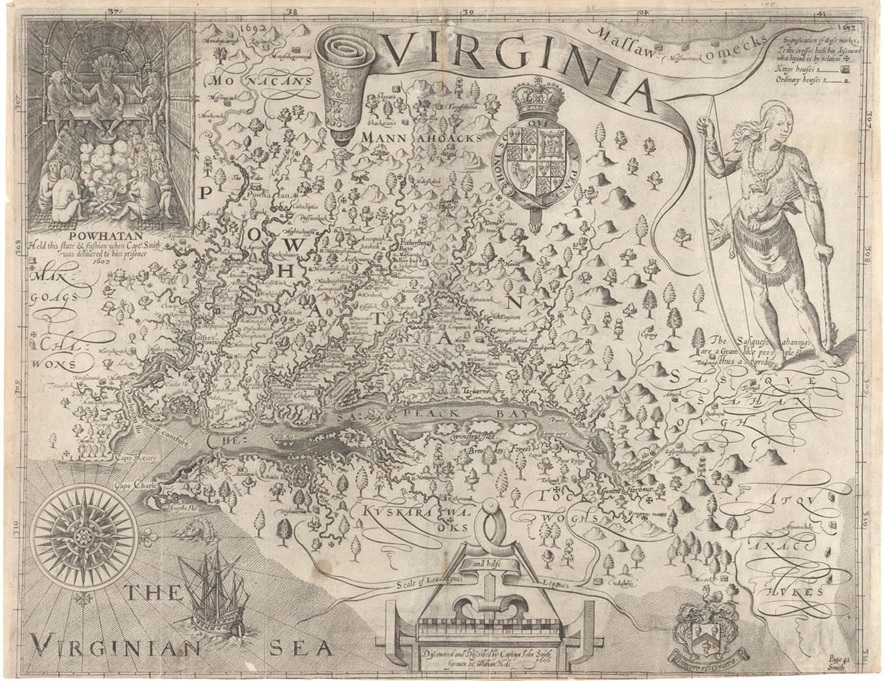
 John Smith, 1606; graven by William Hole")
- Grade Level:
- Middle School: Sixth Grade through Eighth Grade
- Subject:
- Literacy and Language Arts,Social Studies
- Lesson Duration:
- 60 Minutes
- Common Core Standards:
- 4.RI.7, 4.RI.9, 5.RI.3, 5.RI.4, 5.RI.5, 5.RI.7, 6.RI.1, 6.RI.3, 6.RI.4, 6.RI.7, 7.RI.1, 7.RI.4, 7.RI.7, 8.RI.1, 8.RI.4
- State Standards:
- Virginia Standards of Learning
- Additional Standards:
- Common Core History/Social Studies Standards Grades 6-8
CCSS.ELA-Literacy.RH.6-8.1
CCSS.ELA-Literacy.RH.6-8.7 - Thinking Skills:
- Understanding: Understand the main idea of material heard, viewed, or read. Interpret or summarize the ideas in own words. Analyzing: Break down a concept or idea into parts and show the relationships among the parts.
Essential Question
Why can maps tell us about a time in history?
Objective
Students will be able to:
discuss the importance of Captain John Smith's map of Virginia
develop map reading skills and vocabulary
Background
The Age of Exploration ushered in the age of maps. Some maps became so important to travelers that many copies were made of them. These map copies were especially useful to the explorers and settlers of the New World. One such map was Captain John Smith's map of Virginia. Its importance and accuracy (for that time period) also made it one of the most copied maps.
Preparation
Print out reading materials for students and Venn diagram.
Have projector or computers to display John Smith map and modern Virginia map.
Materials
Higher level reading breaking down and studying the map, additional resources, links to related materials, glossary, etc.
Download Library of Virginia Research Notes on Map
Word document of back ground reading and glossary of cartographic (map) terms
Download John Smith Background Student Reading and Glossary
For comparing modern and historic map of Virginia
Procedure
MAP ANALYSIS
Project the Smith map on a screen
- Allow time for students to comment on the map. Define orientation. Point out that the orientation of the map is with north to the right. Note that the embellishment on the compass rose is pointing to the right.
- Have the students identify the map title, compass rose, map legend, any geographic features or symbols, and any place-names. Note that the map scale uses "leagues" and "halfe leagues" as measurement.
- Differentiate between the land features and the water features. Find the Chesapeack Bay, Powhatan Flu (river), Patawomek Flu (river), Toppahanock Flu (river), Pamaunk Flu (river), Virginian Sea, Cape Henry, and Cape Charles. Note the Indian names and the English names. What are these features called today?
- Find the different areas of trees. Do you see an abundance of potential farm land? Find the hunters. Do you expect an abundance of meat for food?
♦ Which American Indian tribes are listed on the map?
♦ Tidewater area (Powhatan = Algonquian language families)
♦ headwaters of the Powhatan Flu (Monacans = Siouan language families)
♦ headwaters of the Toppahanock Flu (Mannahoacks)
♦ southern lands of the Powahatan Flu (Mangoags, Chawons)
♦ Eastern Shore (Delmarva Peninsula) (Kuskarawaocks, Tockwoughs)
♦ upper Chesapeack Bay (Sasquesahanougs, Atquanachukes)
♦ western lands (Massawomecks)
- Look at smaller settlement points across Virginia and close to your present-day location. Do you recognize any names? What Indian names have remained in your community?
- ″Brainstorm ideas about what else John Smith could have put on his map. (economic/trade routes, hunting trails, communication roads, ceremonial locations, entertainment arenas, etc.)
- ″ How would John Smith's map have been beneficial for early European settlers to the region? Does Smith's map show that Virginia was a good source of fresh water? Food? Soil? Building materials? Do you think his map was successful in "selling" Virginia to settlers from Europe? Why or why not?
COMPARE / CONTRAST
- Using a modern wall map of Virginia, compare it with the Smith map.
♦ Have students identify the map title, any geographic features or symbols, and place-names. Note the difference in orientation (westward vs. northward).
♦ Compare the locations of the following places on the maps: Virginia, Maryland, North Carolina, Atlantic Ocean (Virginian Sea), Chesapeake Bay, James River (Powhatan Flu), Jamestown, Richmond, York River (Pamaunk Flu), Yorktown, Werowocomoco (on the north shore of the Pamaunk Flu), Blue Ridge Mountains, Potomac River (Patawomek Flu), Rappahannock River (Toppahanock Flu), Hampton Roads, Washington, D.C., and Virginia's Eastern Shore.
♦ Discuss how place-names can represent geographic features, why place-names may have changed, and whether any commemoration or honor place-names are given. (Explorers may name places for their king/queen/benefactor, the expedition leader, the local native name, what it looks like, a family member, religious figures/reasons, or personal feats, etc.)
♦ Was the area at the mouth of the James River a safe harbor for shipping? What is that area called now? Does the number of ports, cities, and population settlements prove that, after 400 years, Hampton Roads is still a protective harbor? Was Smith correct about Virginia being a source of prosperity?
Vocabulary
• absolute location—the actual location of a point on the earth's surface, usually in terms of latitude and longitude coordinates or a physical address of a place
• cardinal directions—the directions of north, east, south, and west
• cartouche—the ornamental or decorative framing of inscriptions, titles, symbols, and other relevant information on a map
• compass rose—a symbol that shows direction (north, east, south, and west) on a map
• derivative—a copy or modification of an original work
• headwater—the area at the source of a river
• indigenous—native to place
• map—a drawing that shows what places look like from above and where they are located
• map legend—a list of shapes and symbols used on a map and an explanation of what each one represents
• map scale—a map tool used to measure distance between locations
• orientation—direction in relation to a point on the compass
• peninsula—land surrounded by water on three sides
• region—a place that has common characteristics that are different from the characteristics of the surrounding areas
• relative location—a concept described by using terms that show connections between two places, such as next to, near, or bordering
• symbol—a picture or thing that represents something else
• title—the name or kind of map
• tributary—a stream or river that flows into a larger stream or river
Enrichment Activities
Use the Smith map scale to measure distance between places, tribes, and rivers, etc. (one league was about three miles). Use other maps and scales to practice distance.
Compare John Smith's map with any of the Smith derivatives (i.e., Hondius's Nova Virginiae Tabula) and observe the similarities and differences between them (languages, place-names, map tools, etc.).
Additional Resources
Related Links
Online Exhibition: Maps, Charts & Atlases: The Alan M. Voorhees Collection at the Library of Virginia
On the Trail of Captain John Smith: A Jamestown Adventure - National Geographic Kids
Related Lessons or Education Materials
The Chesapeake Bay in John Smith's Time Lesson Plan