


Diving in Cape Cod National Seashore
 Schools of fish gather around structure
In addition to being the summer destination for generations of New Englanders, Cape Cod is an extraordinary landform, comprising one of the world’s largest glacial peninsulas. The wide, sandy beaches are exposed to the North Atlantic along the cape’s entire northern and eastern shores. Blowing sands greet you most of the year, as do shifting dunes-each with their clumps of clinging grass, engaged in a never-ending struggle for a foothold.
Cape Cod is a marvelous place for birdwatching: almost 400 species of marsh dwellers and migratory fowl have been recorded on the cape. You'll find black duck, clapper rail, and belted kingfishers. The National Park Service has also made a special effort to protect the threatened piping plover.
Theoretically, getting around on the cape by car is easy, but in the summertime it can be one solid traffic jam. There are good walking trails, if you want to do some hiking and beachcombing. On most beaches you might expect your foot prints to be washed away in a day, but on the cape, a whole portion of the beach you stroll might disappear overnight, too.
The rich maritime history of Cape Cod is matched by few other places in the world. From the colonial era to the present, it has been a Grand Central Station of shipping lanes and localized maritime activities such as fishing and whaling. With all that traffic, disaster is inevitable: some 3,000 maritime accidents have occurred off this coast, caused by storm and fog and abetted by the limited navigation aids of earlier times. Extreme weather is still a concern, but fog-piercing radar and new technology for positioning vessels now prevent most ship disasters.
Historic lighthouses and lifesaving stations abound on the cape, a testimony to the many stories of shipwreck and survival that have played themselves out along this strip of sand. Sometimes the bones of the ships sunk long ago will appear, only to be covered days later under shifting sands.
Dynamic, expansive, windy, and sandy, with vestiges of maritime history from shore to green depths, Cape Cod beckons you to stay awhile.
BASICS
Location: Atlantic Coast of Massachusetts
Skill level: Intermediate-advanced
Access: Limited diving by shore, unlimited by boat
Dive support: Harwich Port, Provincetown
Best time of year: Summertime, but less crowded in the fall
Visibility: Poor to moderate(7-25 feet)
Highlights: Shipwrecks, rich marine life
Concerns: Ocean currents, cold water, dive sites difficult to locatel
Rules and Regulations
Dive Site Map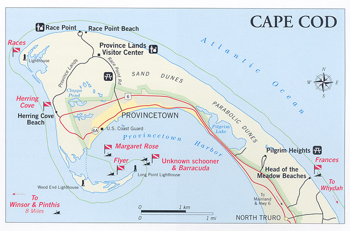
Dive Overview
Shipwrecks are a major focus for the local divers, although most actively dived sites are outside the park. Located a stones throw from park waters is the final resting place of the pirate ship Whydah, which sank in 1717, taking with it more than 145 lives. This ship has remained in the forefront of local consciousness largely because of the schemes of a local treasure hunter who hopes to make his fortune salvaging the Whydah. His attempts are the subject of a fascinating book called Walking the Plank, by Theodore Kiesling.
But shipwrecks aren’t the only attraction here. People often forgot that cold, northern waters are richer in biomass than are tropical seas. If you focus through your face mask on the benthic community, its colorful anemones and busy barnacles, and on the masses of free-swimming fish and scurrying lobsters and crabs, you may find this natural aquarium as intriguing as the Caribbean.
If Cape Cod offers the diver an array of opportunities, it also presents a host of obstacles. There are few dive facilities, a frequently churning sea, and limited information about where the wrecks are. We recommend that you contact divers in the area before visiting to explore the possibility of hiring them to take you diving. Several dive clubs are active on the Cape, and the staff at Cape Cod Divers in Harwich Port may help you find local divers. If you're lucky, they'll get you to some of the excellent wreck dives in Cape Cod Bay.
Dive Sites
PROVINCETOWN HARBOR WRECKS
The craft in Provincetown Harbor are some of the most accessible to dive and lie in the most sheltered waters. The best way to reach these wrecks is by boat from Provincetown. Shore entry is possible on the wreck of the Flyer but the others are either too far from a shore entry point or in areas that have strong current.
Until a few years ago, a line of utility poles served as ranges for locating these wrecks. All the local divers used them. One day the U.S. Coast Guard, fulfilling its mandate to restore seashore property, removed the poles of this long-inactive powerline. We spent the better part of a day with a former captain of a dive charter boat that had visited these wrecks on a regular basis, trying to relocate some of them. Armed with his knowledge and a depth sounder we spent five hours in the harbor hunting for these wrecks. The only one he was able to relocate was the Flyer. Hopefully, the local divers or boat charters will have reoriented themselves in new ranges by the time you visit.
FLYER
This fishing boat is probably the most dived wreck in Provincetown Harbor simply because it is the easiest to find and can be dived from shore. It lies in 45 feet of water about 150 yards from shore-a bit of a swim, but possible. The boat sank in 1972 and is fairly broken up but still a good dive. There is lots of structure for marine life and plenty of good lobster holes. One day we watched a sport diver catch his limit of lobster in 15 minutes. There are good opportunities for photography, but visibility will limit you to close-up work. Local divers say that it can get up to 25 feet; we have seen seven to 15 feet. Clarity is greatest in spring and early summer before the plankton blooms.
MARGARET ROSE
A 105-foot fishing trawler that was on its way to become a floating restaurant when it sank, now lies in about 60 feet of water. The vessel is more or less intact with the top of the pilothouse in about 40 feet of water. It does offer penetration opportunities, but diving can become quite hazardous in certain conditions. Visibility is often less than 10 feet to begin with, and the wrong move can easily provoke the fine sediment on the bottom into billowing clouds that will instantly shrink your perceptual world to a few inches. If you are the first on the wreck during lobster season, however, you won't be disappointed.
CORMORANT, BARRACUDA, AND UNKNOWN SCHOONER
You will probably need local knowledge to find all three. The Cormorant is a wooden fishing boat that is very broken up. The schooner, located somewhere along the inside tip of Long Point, is reported to be a small, two-masted craft. In 1994, one mast was still standing. Once the ranges were cut down, its location became a mystery. The wreck of the Barracuda, a fishing boat, is out around Long Point, and is, therefore, subject to very strong tidal currents.
SEAWARD OF THE CAPE
The area seaward of the cape offers many opportunities to the serious wreck diver. The number of maritime casualties in this area of ocean is rivaled only by the areas off Cape Hatteras and New York and New Jersey. The only way to access these wrecks is with a good boat and local knowledge.
FRANCES
The bark Frances, when it emerges from the sand, is a fascinating dive, but seas there can agitate like a washing machine. It is visible and diveable from the shore, but only when the sea is calm. If you see waves breaking on the structure, stay clear unless you like the idea of tumbling around with jagged metal. The headstone of the captain of the Frances, Wilhelm Kortling, is in the Old North Cemetery (lot 2) in North Truro.
RACES
This is not a wreck dive but a wild drift dive. Do not attempt this without a boat, an experienced boat operator, and experienced divers. The dive is best done on an incoming tide. It starts at the tip of Race Point and finishes at the bath house on Herring Cove beach. You drift over underwater sand dunes that drop off into a sand wall that goes down to between 140 and 170 feet. We asked one local diver what we might expect to see on this dive. "What will you see?" he said. "Could be about anything out there, you should just hope it isn't too close and doesn't have big teeth." Thanks fella.
HERRING COVE BEACH
A beach dive with very easy access-simply park your car in a slot along the unrestricted part of the beach, put your scuba gear on, and walk across the beach 30 feet or so to the water. The area is shallow enough to be a good snorkel but can be scuba-dived as well. (Some local divers maintain that this is a great place for a night dive.) Water depth will range from a few feet down to about 20 feet. When diving this area, you should be careful not to range too far out from shore as you risk being swept up in very strong longshore currents.
As the bottom is sand, pebbles, and small rocks, it is a good place to see bottom-dwelling fish and crustaceans. We've seen numerous flounder, sea robins, and too many crabs to count. The water was clear with about 20-foot- plus visibility.
OTHER DIVING AREAS AROUND THE PARK
The areas around Cape Cod have some fantastic wreck diving. The wrecks are broken down into two main areas: those I found in the bay between the cape and the mainland, and those outside the cape in the Atlantic. These wrecks can only be reached by boat; finding the exact spot requires local knowledge. It is best to book a dive charter boat as they will have the Global Positioning System coordinates of hundreds of wrecks. It will take a lot more than a few free beers at the local watering hole to find out these numbers for yourself.
PINTHIS
Built in 1919, the Pinthis is a 207-foot, steel oil tanker that sank in a collision in 1930, with great loss of life and a tremendous fire that the locals described as looking like Dante's Inferno. It now lies on its side in 108 feet of water between Scituate and Provincetown. Large portions of the ship are intact and the whole thing is covered in a pastel carpet of anemones. Large schools of cunner move in mass along the ship, casting wary glances upon divers as they swim up the inside of the hull. It’s a beautiful wreck and just a sample of the diving possibilities in this area.
WINSOR
The Winsor is a typical turn-of-the-19th-century schooner that went down in 1946. One hundred and fifty-eight feet long with a beam of about 48 feet, she lies in almost 90 feet of water, and sits upright in the sand. Much of the decking is still evident as are the mast steps in the keelson and a scatter of mast hoops used for schooner rigging. The rib timbers jut up out of the sand like the skeleton of some poor desert traveler that lost his way. They are covered with delicate anemones of every color forming a nice frame for fish, particularly cunner, that peer out from behind them.
DIVING RULES AND REGULATIONS
Diver-down flag must be displayed while divers are in water.
Nothing may be removed from a shipwreck that is within the park’s jurisdiction.
All game taking must be in accordance with state laws.
Last Updated: October 26, 2012


