Mission Santa Cruz de San Sabá and Presidio San Luis de las Amarillas -- Spanish Colonial Missions of the Southwest Travel Itinerary

Mission Santa Cruz de San Sabá and Presidio San Luis de las Amarillas

Mission Santa Cruz de San Sabá and Presidio San Luis de las Amarillas
Menard, Texas

Coordinates: 30.922472, -99.801700
#TravelSpanishMissions
Discover Our Shared Heritage
Spanish Colonial Missions of the Southwest Travel Itinerary

San Saba Destruction
"The Destruction of Mission San Sabá in the Province of Texas and the Martyrdom of the Fathers Alonso de Terreros, Joseph Santiesteban.” Painted 7 years after the events, depicts a Spanish interpretation of the destruction of the mission.

Attributed to Jose de Paez, 1765. Courtesy of Wikimedia Commons.

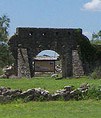
During the Spanish period in Texas, complex interactions between the American Indian groups and the Spanish and French sometimes culminated in violence with missions at the center. One particularly well-documented event was the destruction of Mission Santa Cruz de San Sabá, near what is today Menard, Texas. The Mission San Sabá was established in 1757 for the Lipan Apache. The Lipan Apache, however, had enemies among the Comanche and other northern Texas Indian groups, who, after learning that their enemies would be at the mission, attacked and burned the mission. San Sabá was abandoned after the attack. It was once called "the lost mission of Texas" because its exact location was unknown until the early 1990s. Today, the site is a Texas Historic Landmark and the Presidio San Sabá is on the National Register of Historic Places.
Ruins of Mission Santa Cruz de San Sabá

Photograph by mlhradio via Flickr and creative commons license
Mining Interests and the Missions

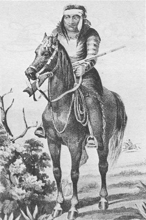
A variety of conflicting interests led to the establishment of Mission Santa Cruz de San Sabá in 1757. The Lipan Apache, who had often raided the Spanish missions to the south near what is today San Antonio, entered into a peace treaty with the Spanish and reportedly requested a mission. The Lipan Apache were pragmatically seeking an ally and some protection from their enemies, which included the Comanche, Tejas, Tonkawas, and Bidais. Spanish officials were happy to pursue peace and establish a presence in an area they thought might soon be claimed by the French. Discovery of silver in the San Sabá country convinced officials to move the San Xavier presidio to San Sabá to serve the Apache, provide a defense against French intrusions, and open the mining district of Los Almagres. Missionaries, escorted by 100 soldiers, volunteered to establish three missions along the Río San Sabá.
Lipan Apache warrior, 1857.

Drawing by Arthur Schott, United States and Mexican Boundary Survey. Courtesy of Wikimedia Commons.
Mine owner Don Pedro de Terreros offered to fund as many as 20 missions for a period of three years to pacify the Apache and other Plains tribes in the area. His cousin, Fray Alonso Giraldo de Terreros, was named Father Superior of those missions. The Spanish established the settlement in 1757, and the priests set the location for the mission relatively far from the Presidio San Sabá, wary from past conflicts and harassment between soldiers and native people. Ultimately, the mission was located a relatively distant four miles from the presidio and on the other side of the San Xavier River.

Missionaries arrive

In 1756, Father Terreros and his missionaries, along with nine Tlaxcalans to help teach the catechism to mission neophytes, reached San Antonio. From there, they proceeded to the Río San Sabá and founded Mission Santa Cruz de San Sabá. Nearby, the soldiers established Presidio San Luis de las Amarillas, or Presidio de San Sabá.

Oddly, when the missionaries arrived at San Sabá, no Indians were there to meet them. Shortly, through messengers, they assembled a large group of Lipan Apaches, numbering 3,000 warriors, who were not interested in a mission or the missionaries. They happened to be hunting buffalo. Other bands among them were a warring party heading north to fight their enemies. None of them were interested or willing to remain at the mission, although some promised to return. Disappointed, some of the missionaries abandoned their assignment and returned to San Antonio. Although the location was good for agriculture, with green pastures and creeks, Colonel Diego Ortiz Parrilla wrote in 1758, "The Apaches were evidently unimpressed by the strength of the new Presidio, for they quite refused to settle at the Mission. Indeed the whole establishment stood like bait at the very edge of the Comanche territory."
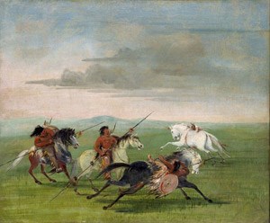
On March 16, 1758, a group of over 1,500 Comanche, Tejas, Tonkawas, Bidais and other northern Texas tribes surrounded the mission looking for Apache. They looted and burned the mission buildings, and although the group was specifically seeking Lipan Apache, two priests, four soldiers, and two mission residents died in the attack. The Comanche considered it a great victory against old enemies, but from the Spanish perspective, it was a massacre. The event touched off a series of Comanche raids. In 1759, over 600 Spanish soldiers from as far away as San Luis Potosí, settlements in Coahuila and Sierra Gorda, along with Tlaxcalan and Apache allies launched a punitive campaign against the northern groups, killing 55 warriors and taking 150 prisoners.
Comanche Feats of Horsemanship. George Catlin 1834.
Comanche Feats of Horsemanship. George Catlin 1834. Comanche raiding became a major problem for Spanish missions in mid to late 18th century.

Smithsonian American Art Museum, Gift of Mrs. Joseph Harrison, Jr.
Finding San Sabá

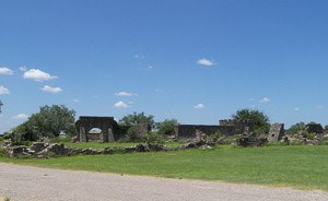
Although the events at Mission Santa Cruz de San Sabá were well documented and the Lipan Apache remembered them in oral histories, San Sabá's location was lost for most of the 20th century and was the subject of searches for many decades. During the Indian raid in 1758, fire destroyed most of the mission's temporary structures of wood, wattle, and daub. Weather and soil tilling over time erased the above-surface features and a large portion of the sub-surface features. In contrast, the Presidio San Sabá was rebuilt of stone in 1761, sending a message to French and American Indian groups that the Spanish intended to stay. The presidio only lasted until 1769, when it and the 130-mile swath of land leading to San Antonio were finally abandoned to the Comanche and their allies. Its more permanent construction made the location easier to find in the 20th century. A Works Progress Administration project rebuilt a portion of the fort for the Texas Centennial in 1936, and today it is open to the public.

The rediscovery of Mission Santa Cruz de San Sabá was the result of years of research and survey. The 1993 discovery of the mission site in an alfalfa field east of Menard came after repeated attempts to find it. Through several field seasons, the archeologists identified soil stains left by wooden poles and posts used in building the mission. In addition to the evidence of the structural components of the mission, they found artifacts like an heirloom brass sundial dating to 1580, lead musket balls, horse bridles, and religious medallions along with a large pit full of burned cattle bone. The rediscovery and excavations were the culmination of decades of searching and generations of researchers.
Mission Santa Cruz de San Sabá and Presidio San Luis de las Amarillas
Presidio San Luis de Las Amarillas, today known as Presidio San Sabá, was established with to help protect the Mission Santa Cruz de San Sabá.

Photo by Larry D. Moore, 2010, CC BY-SA 3.0. Courtesy of Wikimedia Commons.

What you can see today

Mission Santa Cruz de Sabá is a reminder of the complex and sometimes violent interactions among American Indian groups and the Spanish and demonstrates how the Lipan Apache strategically used alliances with the Spanish and missions. The San Sabá Mission site is three miles east of Menard on Farm-to-Market Road 2092. The Texas Centennial Marker is along the highway immediately beside an alfalfa field. A historical marker plaque designates the site today, but there are no visible structures. For more information about the site, visitors can stop by the reconstructed site of the Presidio San Sabá. Visitors can walk through the site, picnic near the stone walls, and enjoy the interpretive panels that detail the history of the presidio and mission. The presidio was reconstructed by a Works Progress Administration project in 1936. Today the Site of Presidio San Luis de las Amarillas, also known as Presidio San Sabá, is on the National Register of Historic Places. Landscaping with native plants and interpretive materials help visitors to visualize what the area looked like in the mid-18th century. Visitors can also get a sense of the historic landscape along the Historic Ditch Walk in downtown Menard that features several historic sites, including the presidio, and walk along the irrigation canal first cut by the Spanish in the 1750s and still used by local farmers today.

Plan Your Visit

Mission Santa Cruz de Sabá is designated by the Texas Historical Commission marker located on Ranch Road 2092 (Farm to Market Road 2092), on the left when traveling east from Menard, TX. The site of Presidio San Luis de las Amarillas, also known as Presidio San Sabá, is on the National Register of Historic Places and is located one mile west of Menard, TX on US 190 at 191 Presidio Rd. Admission is free, and the presidio is open daily with staff on site. For more information, visit the Presidio San Saba website or call 325-396-4682.

Last updated: October 31, 2017

Tools

  • Site Index