Natural Resource Condition Assessments for Fort Pulaski National Monument

The Natural Resource Condition Assessment (NRCA) Program provides framework, funding, and publishing support to parks to aid in the synthesis and documentation of natural resource conditions. Condition assessment reports are a tool to describe selected park resources, and record a snapshot of their current condition, identify trends, and identify potential or current threats and stressors. Understanding the condition and trend of natural resources is key for parks and NPS planners to appropriately prioritize and allocate stewardship resources.
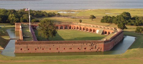
 
View of an old fort
Fort Pulaski from the south, showing damaged areas from cannon fire.

NPS Photo

Fort Pulaski National Monument is located on Cockspur Island near Savannah, Georgia. Masonry fortifications such as Fort Pulaski were common during the 19th century. However, during the Civil War, new technology­—specifically rifled cannon—was able to penetrate the walls of the fort, some 11 feet thick. As a result, military strategy no longer could rely on stone or brick fortifications, and Fort Pulaski has become an artifact of another age. In addition to preserving Fort Pulaski, the park includes most of Cockspur Island and all of the adjacent McQueens Island. The national monument encompasses more than 5,600 acres and includes tidal marshes, woodlands, and mud flats.

For other reports and natural resource datasets visit the NPS Data Store.

Source: Data Store Collection 7765 (results presented are a subset). To search for additional information, visit the Data Store.

Last updated: December 23, 2023

Tools

  • Site Index