|
Anthony C. Caprio, Clarence M. Conover, MaryBeth Keifer, and Pat Lineback ABSTRACTWith limited funding available for prescribed fire, selecting critical areas for burning is increasingly important to land management agencies. This paper presents the process used by Sequoia and Kings Canyon National Parks to integrate hazard, risk, and value criteria as they relate to fire planning within a framework of GIS. Our goal was to identify high priority areas most in need of burn treatment to optimize the use of limited funding. This type of use of GIS is classical, but in an area that has received only minor attention. This application was completed using Arc/Info, Grid, and ArcView 3.0. Three major models were developed. A value model was developed that considers two major components. First, the ecological need component considered fire rotations based on historic fire return intervals (pre 1860) within general plant communities. The longer a time interval exceeded the maximum historic fire interval without a fire, the higher the priority rating for returning fire to this area. The second component of the value model considered infrastructure and human life/safety values. High visitation areas and areas with buildings/facilities were given higher weight and value. A hazard model considered key factors that affect managers' ability to a control a fire, or a fire's resistance to control once ignited. Finally, a risk model was developed that considered historic wildfire occurrence from both human and lightning causes. These three models can be aggregated together in different ways depending on the nature of the questions being asked, or each model can be considered as a separate analysis. As severe wildfires continue to increase each year in North America because of continuing fuel accumulation, it will become increasingly important to use fire as a management option. The use of GIS will be an essential tool for planning and implementing land management programs such fuel modification and ecosystem restoration. BACKGROUNDProject AreaSequoia and Kings Canyon National Parks (SEKI), located in the southern Sierra Nevada, are topographically rugged with elevations ranging from 1,600 to 14,495 feet. Major drainages are the Kern, Kaweah, Kings , and San Joaquin Rivers. The park encompasses some 864,383 acres. Three broad vegetation zones dominate the park, the foothills (1600 to 5000 ft) composed of annual grasslands, oak and evergreen woodlands, and chaparral shrubland, the mixed-conifer forest (5000 to 10000 ft) with ponderosa pine and white and red fir forests, and the high country (10,000 to 14,000 ft) composed of subalpine and alpine vegetation, and unvegetated landscapes. Within the mixed-conifer zone, well-defined groves of giant sequoia are found (Fig. 1). 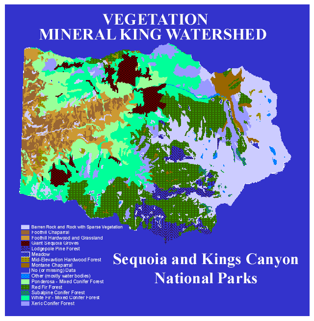
NPS image Climate is distinctly Mediterranean with cool moist winters and warm summers with little rainfall (seasonal summer thunderstorms occur sporadically at higher elevations). Precipitation increases as elevation increases, to about 40 inches annually from 5-8,000 feet on the west slope of the Sierra, and then decreases as one moves higher and to the east. Substantial snow accumulations are common above 5,000 feet during the winter. European settlement of the area began in the 1860s with extensive grazing, logging, and mineral exploration. The parks were founded in 1890, originally with the intent of protecting sequoia groves from logging, but were expanded to include much of the surrounding rugged, high mountains. Historic Fire RegimesHistorically, fire played a key ecological role in most Sierra Nevada plant communities. At the landscape level, fire history research shows an inverse relationship between fire frequency and elevation in areas of mixed-conifer forest (Caprio and Swetnam 1995). Currently, fire history information is lacking for the foothills area of the park. The cause of fires prior to Euroamerican settlement is usually attributed to ignitions by lightning or native Americans. However, since the actual source of these fires cannot be determined, the specific cause(s) remain largely unknown. The seasonal occurrence of historic fires was similar to the contemporary late summer-early fall fire season (Caprio and Swetnam 1995). The size of historic fires was variable; some were very large and burned across multiple watersheds (Caprio unpublished data), while some were restricted to single trees. Fire intensity was variable both spatially and temporally (Stephenson et al. 1991; Caprio et al. 1994). In much of the mixed-conifer zone, fires were primarily non-stand replacing surface fires, although many exceptions exist (Caprio et al. 1994). Specific regional fire years have also been identified, when widespread fires occurred (a result of a single or multiple starts), usually during dry years (Swetnam et al. 1992). Fire regimes in the Sierra Nevada changed dramatically beginning with Euroamerican settlement around 1860-1870 (Kilgore and Taylor 1979, Caprio and Swetnam 1995). Factors that contributed to this decline in fires during the latter portion of the nineteenth century include the loss of native American populations that used fire and heavy livestock grazing that reduced herbaceous fuels available for fire spread (Caprio and Swetnam 1995). The occurrence of fires of large size decreased dramatically during the twentieth century because of active fire suppression. This change in fire regime has lead to unprecedented fuel buildups in many plant communities, structural and composition changes, and has resulted in an increased probability of widespread high intensity burns. Fire as a ToolMost land management agencies classify fires as either a "suppression fire" or a "prescribed fire". The prescribed fire category is further broken down into prescribed natural fires (PNF), ignited naturally by lightning (unplanned ignitions), or management ignited prescribed fires (MIPF; planned ignitions). This paper focuses on the use of planned ignitions to achieve land management goals. Land management agencies intentionally ignite fires for a variety of reasons, including some of the following: fuel reduction for resource protection, site preparation, thinning, elimination of undesirable species, protection of desirable species, and reintroduction of fire as a natural process. Agencies with large land areas are most interested in fire as a natural process. In recent years, federal land management agencies have begun to re-emphasize the return of fire to the ecosystem. Reintroducing fire as a natural process after nearly a century of fuel accumulation will not be easy for many reasons. Some issues include difficulties in fire control and associated costs, unnatural or unwanted fire effects, and social acceptance of fire. Despite these issues, planned ignitions will be a key tool for putting fire back into the ecosystem (Federal Wildland Fire Management Policy and Program Review 1995). MODELSValue ModelThe value model was divided into two components: ecological need and life safety/infrastructure. Ecological Need ComponentThe motivation for an ecological need component was based on the National Park Service's mission statement to "protect and preserve" natural resources. Fire is an important process and component for working towards this goal. The ecological need component provided a rating index to rank areas for the need to burn. All areas within the parks' 11 broad vegetation classes were rated based on fire return interval departures. This rating permitted us to assign priorities based on ranks for all areas in our model. A specific value for each area's fire return interval departure was based on the time since the last fire (TSLF), relative to the maximum average fire return interval (RImax) prior to Euroamerican settlement for each vegetation type. The historic fire regime return interval values (Table 1) were based on reconstructed fire history chronologies derived from tree-ring samples obtained from fire-scarred trees in the vicinity of SEKI, or from the literature if the information for a vegetation type did not exist from within or near the park (Caprio in prep.). To provide a conservative estimate, we used the maximum average return interval for each vegetation class (RImax). The TSLF was derived from historic fire records (these extend back to 1921; see Fig. 2) or based on the last widespread fire date recorded by the fire history reconstructions. Based on the fire history chronologies, the year 1899 was chosen as a conservative base year for the occurrence of the last fire, for all areas where no recent historic fires (since 1921) have occurred. 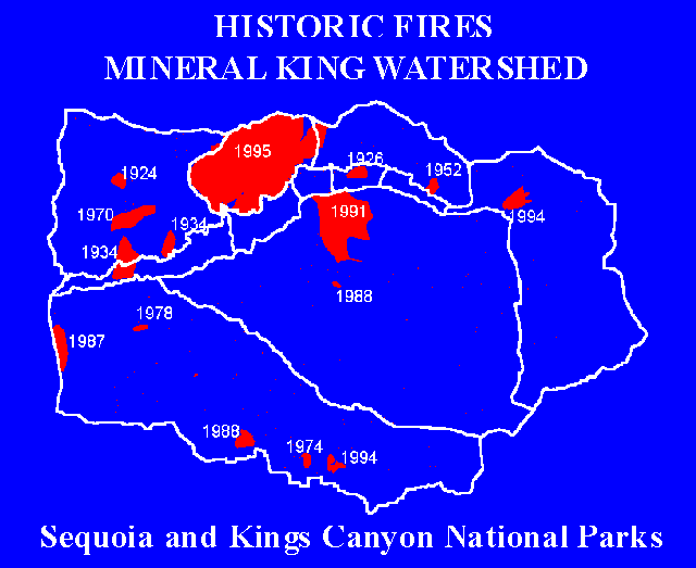
NPS graphic
Using these inputs, a derived index was calculated to quantify the departure of the vegetation type from its pre-Euroamerican settlement fire return interval. The equation for the index is: Fire Return Interval Departure = (RImax - TSLF)/RImax where, RImax = maximum average return interval for vegetation classification, and, TSLF = (time since last fire) time that has passed since the most recent fire from historic fire records or using the baseline date of 1899 derived from the fire history chronologies. The departure index ranges from -16 to 1 given our data set with a beginning TSLF of 1899 and a minimum RImax value of 6. We reclassed the index values into four rating categories that we felt captured current forest conditions and the need for burning based on historical fire intervals (Table 2). Table 2.
Using this component of the model, these categories were mapped spatially across the parks using GIS (Fig. 3). While the dominant ecological need category was "moderate" (Table 3), the "extreme" and "high" categories are most important in the lower elevation conifer forests, an area of high visitor use. 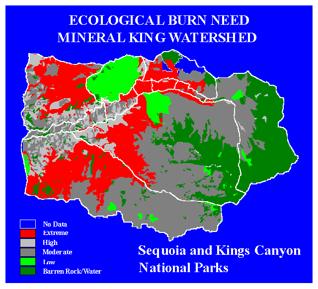
NPS graphic
Table 3
Infrastructure and Life/Safety ComponentIn this component of the value model, we addressed the anthropogenic and natural resources on the landscape that could potentially be impacted by fire. The component included two factors: infrastructure values, and human life/safety values. Each factor was divided into three categories: high, moderate, or low, based on a number of criteria (Table 4 and Table 5). Table 4
Table 5.
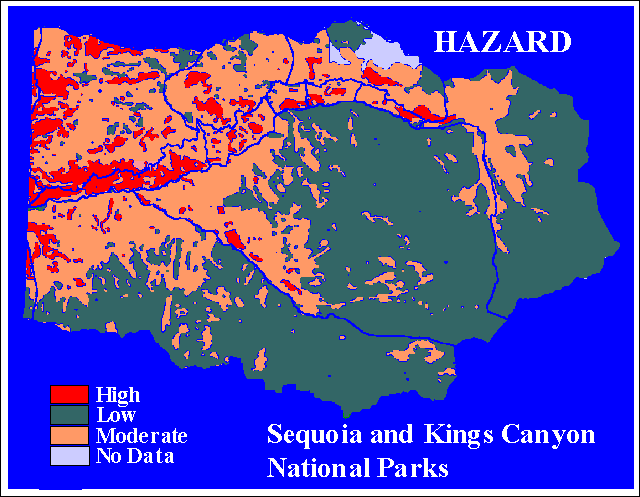
Hazard ModelIn the hazard model we examined key parameters that affect managers' ability to control fire (ie. resistance to control). The four parameters were, 1) fuel model, 2) slope, 3) elevation, and 4) aspect. Slope, aspect, and elevation were derived from a digital elevation model (DEM). The fuel models used (Fig. 4) were the thirteen standard fuel models for fire behavior estimation (Albini, 1976). Future updates of the model will probably include site specific "custom models" (Burgan and Rothermel, 1984). Each of the four parameters was divided into three categories: high, moderate, or low, based on specific elements within each parameter (Table 6). Applying this model using GIS (Fig. 5) indicated that the largest portion of the parks was in the low hazard category and the smallest portion was in the high category (Table 7). 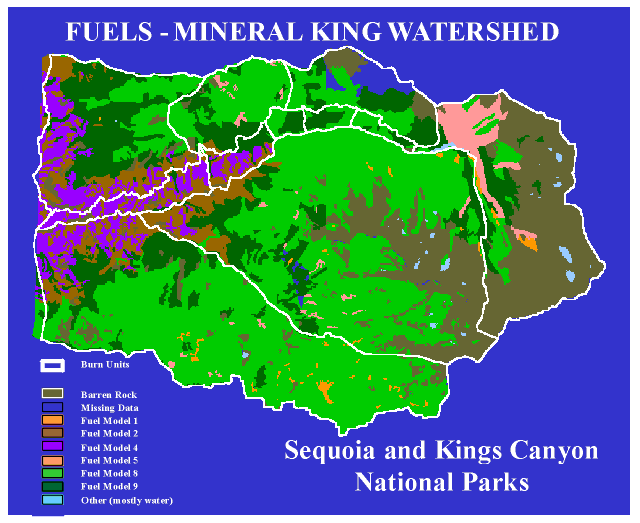
NPS graphic
NPS graphic
Table 7
Risk ModelIn the risk model we identified the risk of potential ignitions by looking at the historic occurrence of both human and naturally (ie. lightning) caused fires. We divided the parks into watersheds and plotted the occurrence of reportable fires over the last ten years of record. The data for each watershed was analyzed and classified into areas of high, moderate, and low risk. A ratio was developed for the number of ignitions/1000 acres for each watershed to allow a comparison between watersheds. A key assumption in the risk model was that locations where fire ignitions have historically occurred will continue to be sources of ignition. SUMMARYThe framework presented for the development of GIS models for prioritizing fire planning needs produce simple, color-coded ratings viewed on park maps for each of the model components. In this way, the areas with the highest priority ratings based on either value, hazard, or risk can be viewed spatially when determining which areas to focus planned ignition efforts. Depending on the program goals and questions asked, the models can be used separately or integrated, using either overlays or by combining model algorithms to produce single maps of a combination of models. Other applications for this framework include: fire prevention planning, fire preparedness planning, and use in National Environmental Policy Act (NEPA) compliance documents. FUTURE MODEL CONSIDERATIONSAs these models evolved and developed, potential improvements were identified in the form of model validation, improved source data, and model refinement. Some of the planned changes include the following:
ACKNOWLEDGEMENTSWe would like to thank the staff of Sequoia and Kings Canyon National Parks, including Jeff Manley, Bill Kaage, Scott Williams, Linda Mutch, Ed Nelson, and Dan Buckley, whose collective effort and input has made this project possible. REFERENCESAlbini, Frank A., 1976. Estimating wildfire behavior and effects. USDA For. Serv. Gen. Tech. Rep. INT-30, 92 p. Intermountain Forest and Range Experiment Station, Ogden, Utah. Burgan, Robert E.; Rothermel, Richard C. BEHAVE: Fire Behavior Prediction and Fuel Modeling System - FUEL Subsystem. USDA For. Serv. Gen. Tech. Rep. INT- 167, 126 p. Intermountain Forest and Range Experiment Station, Ogden, Utah. Caprio, A.C., L.S. Mutch, T.W. Swetnam, and C.H. Baisan. 1994. Temporal and spatial patterns of giant sequoia radial growth response to a high severity fire in A.D. 1297. Final Report of California Department of Forestry and Fire Protection, Mountain Home State Forest, Contract No. 8CA17025, Laboratory of Tree-Ring Research, University of Arizona, Tucson. Caprio, A.C. and T.W. Swetnam. 1995. Historic fire regimes along an elevational gradient on the west slope of the Sierra Nevada, California. In: J.K. Brown, R.W. Mutch, C.W. Spoon, R.H. Wakimoto (tech. coord.). Proceedings: Symposium on Fire in Wilderness and Park Management: Past Lessons and Future Opportunities, March 30-April 1, 1993, Missoula Montana. USDA Forest Service, INT-GTR-320. Kilgore, B.M. and D. Taylor. 1979. Fire history of a sequoia mixed-conifer forest. Ecol. 60:129-142. Stephenson, N.L., D.J. Parsons, and T.W. Swetnam. 1991. Restoring natural fire to the Sequoia-mixed conifer forest: should intense fire play a role? In: 17th Proceedings of the Tall Timbers Fire Ecology Conference, pp. 321-337. Swetnam, T.W., C.H. Baisan, A.C. Caprio, R. Touchan, and P.M. Brown. 1992. Tree-ring reconstruction of giant sequoia fire regimes. Final report to Sequoia, Kings Canyon and Yosemite National Parks, Laboratory of Tree-Ring Research, Tucson, AZ. 90 pp. + appendices. USDI and USDA. 1995. Federal Wildland Fire Management Policy and Program Review. Final Report. AUTHOR INFORMATIONAnthony C. Caprio Clarence M. Conover MaryBeth Keifer Pat Lineback | ||||||||||||||||||||||||||||||||||||||||||||||||||||||||||||||||||||||||||||||||||||||||||||||||||||||||||||||||||
Last updated: March 1, 2015