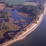
The Coastal Plain of the Lower Potomac is part of what is known locally as Tidewater Virginia. The name goes much deeper than the fact that water levels rise and fall with the Atlantic Ocean tides. The river bottom, is the repository of all the sand and sediment that has flowed down the river for about 10,000 year. This mile-deep surface of muck and sand extends beyond the Chesapeake Bay hundred miles into the ocean, where it ends at the Continental Shelf. The river, its tributaries and shore are influenced by the continuous churning of tides. The land of Virginia’s Lower Potomac was formed by similar action. The land, writes Karen T. Zachary in Cultural Landscapes of the Potomac, is “underlain by a complex mosaic of unconsolidated fluvial and marine sediments life in place by the ebb and flow of ancient oceans. Soils vary from inundated highly organic soil, poorly drained clays, moderately drained silts and well-drained gravel. The typography is flat producing extensive floodplains and wetlands.” “The Potomac estuary dominates the hydrology of the Coastal Plain,” she continues. “The tributary streams are short and of a low gradient. Flooding is a perennial problem…caused by low-pressure Atlantic storms and high tides.” |
Last updated: April 10, 2015
