Last updated: April 15, 2026
Place
Valley of Ten Thousand Smokes

NPS Photo / M. Fitz
Quick Facts
Location:
Valley of Ten Thousand Smokes
Significance:
Historic Eruption Site
Designation:
Wilderness
MANAGED BY:
Amenities
6 listed
Bus/Shuttle Stop, Historical/Interpretive Information/Exhibits, Information, Information - Ranger/Staff Member Present, Restroom, Tactile Exhibit
On June 6, 1912, a new volcano emerged on the Katmai landscape and forever altered this region. For 60 hours, a volcano later named Novarupta sent ash into the sky as high as 20 miles (30 km). Ash and pumice from the eruption also rushed down the Ukak River valley as pyroclastic flows and surges moving at more than 100 miles per hour (160 kilometers per hour).
The Ukak River valley was transformed into 40 square miles (64 square kilometers) of barren ash. Heat trapped in the ash took decades to cool. Any water buried by the ash or that percolated into it flashed into steam. The vents where the superheated steam emerged became the fumaroles that inspired the name Valley of Ten Thousand Smokes.
Today the Valley of Ten Thousand Smokes (i.e. the Valley) offers a chance to explore a landscape created by the largest volcanic eruption of the 20th century. The beauty, scale, wildness, and mystery of the Valley make it one of the best places in the world to study the violence of volcanic eruptions and experience the raw power of nature.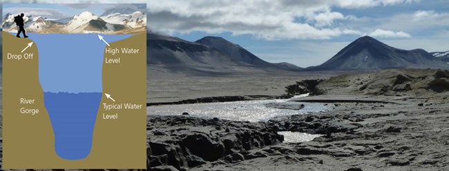
You must approach river crossings in the Valley with caution. Rivers and streams are typically shallower and easier to cross at their widest margin. In flood conditions, deep gorges can be hidden (see inset).
The Valley of Ten Thousand Smokes poses special challenges for backcountry travelers. Suspended volcanic ash and glacially-derived sediments in rivers often make water depths impossible to estimate, and most of the rivers in the Valley are confined to narrow gorges that are deceptively deep and swift. Hikers must be especially cautious when choosing a place to cross the Valley’s rivers and creeks. The River Lethe and Knife Creek, for example, can only be forded in a few places.
If you cannot find a safe crossing, then you should not attempt to cross. You may also need to wait a day or longer until lower water levels permit safe crossing. Follow these tips when crossing:
The Ukak River valley was transformed into 40 square miles (64 square kilometers) of barren ash. Heat trapped in the ash took decades to cool. Any water buried by the ash or that percolated into it flashed into steam. The vents where the superheated steam emerged became the fumaroles that inspired the name Valley of Ten Thousand Smokes.
Today the Valley of Ten Thousand Smokes (i.e. the Valley) offers a chance to explore a landscape created by the largest volcanic eruption of the 20th century. The beauty, scale, wildness, and mystery of the Valley make it one of the best places in the world to study the violence of volcanic eruptions and experience the raw power of nature.
Destinations in the Valley of Ten Thousand Smokes
- Buttress Range
- Katmai Pass and the Southwest Trident Lava Flows
- Knife Creek Glaciers and the Mount Katmai Caldera
- Mount Griggs
- Mageik Lakes
- Novarupta
River Crossings in the Valley of Ten Thousand Smokes
You must approach river crossings in the Valley with caution. Rivers and streams are typically shallower and easier to cross at their widest margin. In flood conditions, deep gorges can be hidden (see inset).
The Valley of Ten Thousand Smokes poses special challenges for backcountry travelers. Suspended volcanic ash and glacially-derived sediments in rivers often make water depths impossible to estimate, and most of the rivers in the Valley are confined to narrow gorges that are deceptively deep and swift. Hikers must be especially cautious when choosing a place to cross the Valley’s rivers and creeks. The River Lethe and Knife Creek, for example, can only be forded in a few places.
If you cannot find a safe crossing, then you should not attempt to cross. You may also need to wait a day or longer until lower water levels permit safe crossing. Follow these tips when crossing:
- Watch the water’s surface and cross where you see small ripples, not waves.
- Cross early in the morning when runoff from glaciers is low.
- Release your pack’s belt buckle and loosen shoulder straps so you can drop your pack easily.
- Wear shoes while crossing.
- Allow yourself a retreat. Don’t commit to one route.
- Use a hiking pole or stick to help steady yourself and gauge the water’s depth.
Other Information
- Drinking Water: By August, drinking water can be scarce in the Valley of Ten Thousand Smokes, especially in its central region. On the margins of the Valley perennial snow fields, meltwater channels, seeps, and springs provide water throughout the year. Some of the streams and rivers in the Valley, however, carry very high loads of glacial flour, silt, sand, and pumice which easily clog water filters.
- Best Practices: follow "leave no trace" principles & backcountry regulations.
- Access to the Valley of Ten Thousand Smokes: Transportation to the Valley is available on the Valley of Ten Thousand Smokes Tour. Hikers can arranged to be dropped off at the Valley and picked up at a later date. Contact the park’s concessionaire Katmailand for fees and more information. USGS topographic maps for the Valley include Mt. Katmai B-4 and B-5 among others. Visit the USGS Map Store or Alaska Geographic to purchase maps. The Brooks Camp and King Salmon visitor centers maintain a limited stock only. All food must be stored in bear resistant containers, which are available free of charge at the King Salmon and Brooks Camp visitor centers. Although permits are not required for backcountry travel or camping, hikers are encouraged to submit a Backcountry Trip Planner.
- Baked Mountain Huts: The Baked Mountain Huts were destroyed in a 2018 storm and are no longer safe to be used as any type of shelter.