Last updated: August 18, 2023
Place
World War II Radar Station: B-71
National Park Service
Quick Facts
Location:
Coastal Drive. West of Klamath, CA
Significance:
Disguised WWII Radar Station
Designation:
National Register of Historic Places
Amenities
3 listed
Historical/Interpretive Information/Exhibits, Parking - Auto, Trailhead
The Klamath River Radar Station B-71, located near Klamath, California, is a rare, surviving World War II early-warning radar station. Modern radar was a very new technology in the 1940s and radar stations like B-71 were one of the first steps towards today's more sophisticated early warning radar defense network.
Why build radar stations?
As a result of the attacks on Pearl Harbor and the Aleutian Islands, the need to guard the American coastline on the Pacific Ocean became more important. This was made urgent when Japanese submarines shelled an oil refinery north of Santa Barbara, California, on February 23, 1942; Esteven Point in British Columbia, Canada, on June 20, 1942; and again at Fort Stevens, Washington, on July 21, 1942. On September 9, 1942, a Japanese submarine-launched aircraft dropped incendiary bombs on Oregon forests roughly 40 miles north of the Klamath River.
To protect the Pacific Coast from further attacks, a network of 72 radar stations was proposed as part of a radar air defense network. Although only 65 stations were actually built, the network stretched from the US/Canada border into Mexico.
About the Station
As part of the coastal radar air defense network, a station was built approximately two miles south of the mouth of the Klamath River in what is now Redwood National and State Parks. The radar station was designated Station B-71, (named "Trinidad") by a memorandum from the Office of the Commanding General, IV Fighter Command dated November 6, 1942. It was also referred to as the "Klamath River" station and was the northernmost coastal radar station in California.
The radar station was manned by members of the US Army Air Corps quartered in barracks near the town of Klamath. It was commanded during part of 1943 by 2nd Lieutenant Neff, later replaced by one or more 1st lieutenants in succession. The station was manned around the clock. A single day's operation of the station required a crew of about 35 men to work the 24 hours in shifts. It was also guarded by military police with dogs and had three anti-aircraft guns.
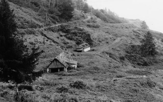
The buildings that made up the station were fairly unique in that their camouflage was "built-in". Most camouflage of structures disguised already existing buildings, but the buildings at Radar Station B-71 were new. This meant that they could be built with camouflaging as part of their new construction. The buildings were built to be disguised as a farm.
The station consisted of three buildings: a Power Building disguised as a farmhouse, an Operations Building disguised as a barn, a functional wood frame two-stall Privy or outhouse, and three anti-aircraft guns.
Power Building
As its name implies, the Power Building housed the power generators needed to run the radar equipment. Located south of the Operations Building, it was camouflaged to look like a farmhouse. The actual building was a rectangular structure made of concrete blocks. In order to disguise the concrete walls they were covered with false exterior wooden walls. The false walls were made of vertical board and batten siding on a wood frame and were secured to the concrete blocks. A number of fake windows were built Into the false walls but they did not penetrate the concrete walls. The building also had a large wood-shingled gable roof with two false dormer windows. The dormers sat on top of the roof but didn't open into the roof space. The roof style, dormers, and wooden walls and windows all disguised the concrete building and added to the impression that it was really a farmhouse.
Operations Building
The Operations Building housed the oscilloscope and operating personnel and was disguised to look like a barn. A false barn door at the north end sat under a roof gable. An extension of the roof simulated the track for a traveling pulley hoist which, in a real barn, would have been used for moving bales of hay. The exterior concrete block walls were disguised with false wood siding whose outer edge was five or six inches beyond the outer face of the concrete walls. The interior of the operations building was divided into about seven rooms. The rooms all had acoustic tile ceilings and at least one room also had acoustic wall tiles.
During the first half of 1943 a mobile SCR-270B radar antenna was installed uncamouflaged about 30 feet west of the operations building. It consisted of a rectangular metal grid mounted vertically on a pole of triangular metal framework. The whole assembly was carried on a wheeled trailer to make it mobile. At a later date more permanent antenna were installed.
Privy (outhouse)
The two-stall privy was a wood frame structure located 95 feet north of the operations building. It has largely eroded away.
Anti-Aircraft Guns
Southwest of the power building is the remains of a circular pit about twelve feet in diameter which may have been the location of one of the three M2 (Browning) .50 caliber machine guns. The guns were on anti-aircraft mounts and protected the station. Northwest of the operations building is the remains of a similar circular pit which is believed to be the site of a second .50 caliber machine gun. The location of the third gun mount site is unknown.
End of Service
As the threat of Japanese attack waned towards the end of World War II, the coastal early radar stations began to be phased out of service. While the need for early-warning radar decreased, the need for air-sea rescue radar increased, Effective July 1, 1944, Radar Station B-71 was converted to emergency rescue service, with the SCR-271 radar being replaced with RC-150 IFF equipment. The station was thus one of only 22 radar stations on the entire Pacific Coast to remained in operation until the end of World War II
Preserving the Station
After the war, Radar Station B-71 was abandoned and it reverted to private ownership until the National Park Service acquired it with the creation of what was then known as Redwood National Park. The topography of the site has created conservation challenges with runoff and erosion causing mud to be deposited against the structure. The constant moisture has also damaged the remaining siding in some areas. The buildings are still standing, but are weathered. The first known photographs of the site date to the 1970s. Unfortunately, no photos of the site are known to exist from World War II.
Despite standing empty since the end of the war, Klamath River Radar Station B-71 remains one of the few World War radar stations still in existence in the US. The station is listed on the National Park Service's National Register of Historic Places (NRHP No. 78000282) and was document by the Historic American Engineering Record (HAER-CA 332).
Visiting the Site
The Klamath River Radar Station B-71 site and buildings are part of Redwood National and State Parks. Anyone may visit the site either in a vehicle or by hiking to its trailhead. The site is reached from the pull off at the WWII Radar Farmhouse Trailhead by walking along the short WWII Radar Farmhouse Trail.
Vehicles
Access to the trailhead is off the Coastal Drive. The Coastal Drive is a narrow, unpaved, gravel road. The road is not recommended for recreational vehicles or busses. Motor homes or vehicles towing a trailer are not allowed on this road. Visitors arriving by vehicle may pull off at the WWII Radar Farmhouse Trailhead.
Hiking
Visitors hiking the Flint Ridge Trail or camping at the Flint Ridge Camp may visit Radar Station B-71 by walking approximately .5 miles south from the camp (west trailhead) along the Coastal Drive (Trail) to the WWII Radar Farmhouse Trailhead.