Last updated: November 22, 2024
Place
Paradise Meadows & Skyline Trailhead
NPS Photo
Quick Facts
Location:
Paradise
Amenities
14 listed
Benches/Seating, Cellular Signal, Information Kiosk/Bulletin Board, Parking - Auto, Parking - Bus/RV, Picnic Table, Restroom, Restroom - Accessible, Scenic View/Photo Spot, Toilet - Flush, Trailhead, Trash Dumpster, Trash/Litter Receptacles, Water - Drinking/Potable
Season: Year-Round
Summer/Fall (July - September): Paradise is an extremely popular destination. To avoid congestion, visit earlier or later in the day or on a weekday.
Winter/Spring (October - June): The Paradise Meadows are covered in deep snow in winter, but the area remains open for snowshoeing and other winter recreation. The road to Paradise closes nightly at the gate at Longmire typically from November to mid-April depending on weather; always check road status before starting your trip. Snow can linger well into June or even July.
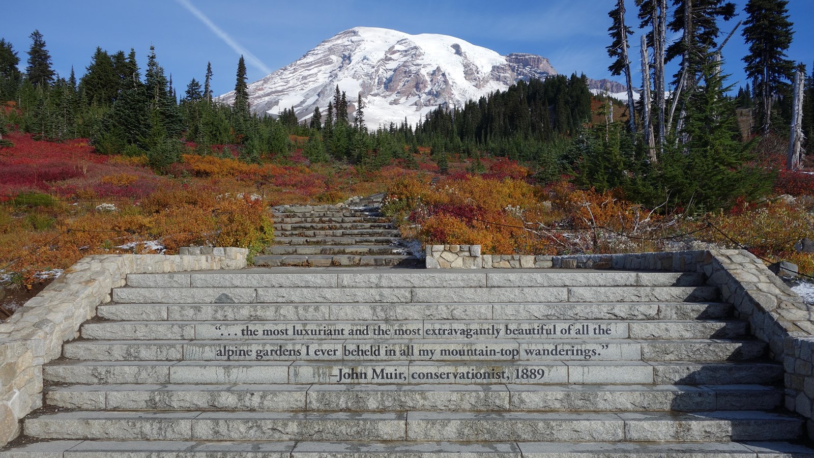
Starting from the Muir Steps, a set of steps inscribed with a quote by John Muir, a network of trails weave through the famous subalpine meadows of Paradise. There is a ramp to access the trails to the right of the Muir Steps. Views along the trails include Mount Rainier as well as the Tatoosh Range, Mount Adams, Mount St. Helens, and the Cascade Range. Look for wildlife, including black-tailed deer, marmots, and birds, in the meadows. The meadows fill with a wide variety of flowers, with peak bloom in late July or early August, and can have colorful fall foliage starting in September. During the winter, trails in Paradise are covered by a deep layer of snow and are mostly unmarked. Snowshoers should have experience with route finding and avalanche terrain. Always check current conditions before heading out and be prepared with the Ten Essentials.
Please do not feed any wildlife. Stay on the trail at all times to protect the delicate subalpine vegetation. Pets are not allowed on trails. Download a Paradise Area Trails Map or pick up a map from a ranger at the Jackson Visitor Center before starting your hike.
Skyline Trail - 5.5 miles round-trip, 1700 feet elevation gain.
The Skyline Trail is the premiere loop trail through the Paradise Meadows. There are several side trails to modify the main route, which may add or decrease the total trail length and elevation change of your hike.
Hiking the loop clockwise, the trail climbs 2 miles until reaching Panorama Point, where a toilet is provided for hikers. Past Panorama Point use of the High Skyline Trail avoids a dangerous icy slope that does not melt. This connects back to the Skyline above the junction with Golden Gate trail (an alternative for a shorter hike). Another 0.75 mile and the Skyline Trail reaches the Stevens-Van Trump Memorial and its junction with the Paradise Glacier Trail. From there it descends into the Paradise Valley, then climbs slightly to Myrtle Falls and finally back to Paradise.
Deadhorse Creek Trail and Moraine Trail - 2.5 miles round-trip, 400 feet elevation gain.
For excellent views of the Nisqually Glacier, follow Deadhorse Creek Trail to Glacier Vista and return via the Skyline Trail.
Alta Vista via the Alta Vista and Skyline Trails - 1.75 miles round-trip, 600 feet elevation gain.
Follow the Skyline Trail and then climb up to Alta Vista at 5,940 feet for views of Mount Rainier and the surrounding Paradise Meadows. Return via the Alta Vista Trail.
Lakes Trail Loop, via Reflection Lake - 5 miles round-trip, 1300 feet elevation gain.
This trail follows the southern portion of the Skyline Trail to connect to the Lakes Trail and loop around the Paradise Valley. Consider parking at Reflection Lakes and hiking up to Paradise, then returning downhill to your vehicle.
Skyline Trail to Myrtle Falls - 1 mile round-trip, 100 feet elevation gain.
Suitable for wheelchairs with help and strollers, this easy portion of the Skyline Trail leads to a scenic waterfall with views of Mount Rainier.
Nisqually Vista Trail - 1.2 miles round-trip, 200 feet elevation gain.
Connect to the Nisqually Vista Trail from the main Paradise Meadows Trailhead or start this trail from the west end of lower Paradise parking lot. This easy trail features viewpoints overlooking the Nisqually Glacier and Nisqually River Valley.
Skyline Trail Map
Map centered on the Skyline Trail in the Paradise Area of Mount Rainier National Park. The trailhead is located by the Jackson Visitor Center. There is a network of trails starting from the same trailhead. The Skyline Trail climbs north through the Paradise Meadows to Panorama Point, then loops east and south to return to Paradise. Points of interest are marked by black symbols on the map. Several tools are represented by icons along the left side of the map. A ruler icon opens a tool to measure distance or area on the map. Clicking on plus or minus icons will zoom the view in/out, and clicking on a house icon will return the map to the original view centered on the Skyline Trail.