Last updated: March 4, 2026
Place
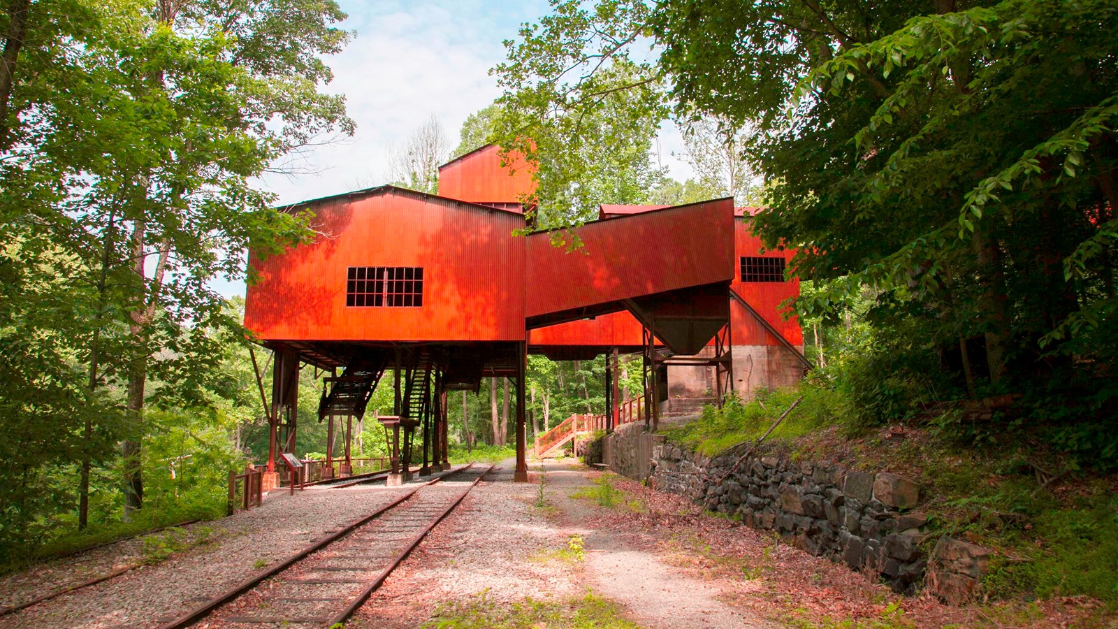
Nuttallburg
NPS/Louise McLaughlin
Quick Facts
Location:
Nuttallburg, WV
Significance:
Today, Nuttallburg is preserved as one of the best examples of a coal mining town of it's era anywhere in the United States.
Amenities
5 listed
Historical/Interpretive Information/Exhibits, Parking - Auto, Scenic View/Photo Spot, Toilet - Vault/Composting, Trailhead
African American Heritage Driving Tour Stop 4: African American Life in a Coal Camp
If using the NPS app, to listen to the audio narrative, press the green button below or read the audio narrative text below.
This tour stop is not advised for trailers, RVs, or motorhomes due to narrow roadways, limited parking, and difficulty turning around.
Audio Narration
Written By: Dr. Michael Workman
Narrated By: Doris A. Fields
Quote By: Mark Bollinger
Company Towns:
You live in a company house. You go to a company school.You work for this company according to the company rules.You all drink company water and all use company lights.The company preacher teaches us. What the company thinks is right.
Carl Sandburg
In the late 1800s, coal became King in West Virginia. Over a sixty-year period, hundreds of coal mines were opened throughout southern West Virginia. To dig the coal, thousands of native Appalachians, African Americans, and immigrants from Europe migrated to the coal fields to work in the mines. To support the mining operations and their workers, “coal camps” became as numerous as the coal mines. Company towns, or “coal camps” as they were commonly known, were built and owned by the coal companies themselves. They provided miners and their families a place to live, a place to buy goods and services, as well as opportunities for personal and recreational activities. In 1930, there were nearly 500 coal company towns in West Virginia.
The vast majority of African Americans who migrated to southern West Virginia found new lives in coal company towns. These mining camps were favored by Black migrants because jobs were there. Camps also provided available and affordable housing. The 1900 U.S. census shows that a majority of residents in many of the coal camps were African American. Blacks living and working in mining camps like Nuttallburg, Hawks Nest, and Stonecliff made up over 55 percent of the population.
The Nuttallburg mine and company town provides a fine example of an early New River Gorge coal mining operation. John Nuttal, an immigrant from England, purchased land along the New River and founded the Nuttallburg Coal & Coke Company. He built a company town along the north side of the New River near the mouth of Short Creek. In 1900, most of the African American men in Nuttallburg worked in the mine. There were blacks that also worked for the railroad and in construction. One African American worked as a clerk at the company store and another was a coke yard boss. For some 85 years, the Nuttallburg mine and coal camp provided work and a way of life for many African Americans.
A coal company usually purchased or leased land around the mining operation on which to construct a town. A typical coal camp consisted of the tipple, coke ovens, a company store, church, school, post office, and company-owned housing. In 1890, there were 110 company-owned houses in Nuttallburg. Monthly rental on a simple four-room company house amounted to one or two day’s wages. A 1922 survey found that over 80 percent of West Virginia miners rented their homes from a coal company. By 1900, Nuttallburg also had a doctor’s office, blacksmith shop, club houses, and recreational facilities.
What was life like for black miners and their families living in a company town? Interviews of former coal camp residents indicate that segregation by status, race, and ethnicity existed in the coal camps. Blacks and Whites lived in different neighborhoods, worshiped in separate churches, and attended segregated schools. Housing for African Americans was often located on the outskirts of the camp or in a different hollow all together. In Nuttallburg, Short Creek divided the town. Blacks lived on the east side of the creek; whites lived on the west side. Both communities had their own school, church, and clubhouses.
In the African American community, children attended a company school for black students. These schools typically went from first to eighth grade and ran five to six months a year. Students old enough to attend high school rode the train or bus to the closest town that had a Black high school. The church was an important part of the African American community in the coal camps. It offered both spiritual and social activities weekly and throughout the year. Most residents were Baptists or Methodist who enthusiastically participated in church services and events.
When not working in the mines, black miners and their families enjoyed a variety of leisure and recreational activities within their community. Hunting and fishing were popular. Black residents enjoyed going to the theater, club houses, dance halls, and bowling alleys. Members of the community often gathered on front porches to play their guitars, banjos, and fiddles and to sing. Many African Americans spent Sunday afternoon visiting family and friends or watching a baseball game. Baseball was the miner's favorite sport with many camps having an all-Black and all-White ball team. The Sunday afternoon baseball game was a major social event in the black community.
During the 1950s, life in the coal camp began to change dramatically. As mechanization of the mines increased, more and more miners lost their jobs. It was often the Black miner who lost his job first. Without a job in the mine, the miner could no longer live in company housing. Without a home or job, miners and their families left the coal camps in search of jobs elsewhere.
The coal camp was never meant to be a permanent community. It was built and maintained to last only as long as the mine was open. When the coal seam played-out, coal companies simply packed up and moved on. They might dismantle and move some of the buildings to the next mining site or sell their residential properties to residents staying behind. However, without the mine operating and fewer people living there, the conditions of company towns deteriorated as time passed. Buildings that were not being used or lived in began falling down. Today there are no company-owned coal camps left in West Virginia.
Sources
Bailey, Kenneth R. “A Judicious Mixture: Negroes and Immigrants in the West Virginia Mines, 1880-1917,” West Virginia History.
Black Diamond, Volume 68, No. 25 (June 24, 1922).
Lewis, Ronald L. Black Coal Miners in America. University Press of Kentucky, 1987.
Miller, Truman I. Miner, A Life Underground. Lexington, KY: Bacchante Books, 2015.
Tams . W.P. Jr. The Smokeless Coal Fields of West Virginia. Morgantown, WV: West Virginia University Press, 1963, 2001.
Joe Trotter, “Black Migration to Southern West Virginia,” in Transnational West Virginia, editors, Ken Fones-Wolf and Ronald L. Lewis. West Virginia University Press, 2002.
White, I.C. Report on Coal, Vol. Two, West Virginia Geological Survey. Morgantown, W.Va.: Morgantown Post Company, 1903.
West Virginia Department of Mines, Annual Report, Various, 1883 - 1940.
Workman, Michael, “Coal Mining in the United States: A Technological Context,” Institute for History of Technology & Industrial Archaeology, 2000, Unpublished manuscript.
U.S. Census, 1900 - 1940, Fayette & Raleigh Counties, manuscript copy, accessed at ancestry.com.
Downing, Bob. History-Rich Nuttallburg tells story of coal mining in West Virginia’s New River Gorge. Akron Beacon Journal, 2013
Background Information:
In the late 1800s, coal became King in West Virginia. Over a sixty-year period, hundreds of coal mines were opened throughout southern West Virginia. To dig the coal, thousands of native Appalachians, African Americans, and immigrants from Europe migrated to the coal fields to work in the mines. To support the mining operations and their workers, “coal camps” became as numerous as the coal mines. Company towns, or “coal camps” as they were commonly known, were built and owned by the coal companies themselves. They provided miners and their families a place to live, a place to buy goods and services, as well as opportunities for personal and recreational activities. In 1930, there were nearly 500 coal company towns in West Virginia.
John Nuttall purchased a large tract of land in 1870 on the New River along Short Creek. With the completion of the C&O Railroad in 1873, he opened the Nuttallburg mine and began building his company town which came to be called Nuttallburg. After John Nuttall died in 1897 his heirs ran Nuttallburg until Henry Ford leased the town’s mines to provide coal for his company steel mills in the 1920s. Nuttallburg passed through three more owners after Henry Ford, then ceased production in 1958.
For the full story go to: African American Life in a Coal Camp: Nuttallburg
Driving Directions:
Nuttallburg
Add Physical Address: Keeney’s Creek Road
Add GPS Coordinates: N38.049301 -W81.038065
Use caution when driving to Nuttallburg. The road to Nuttallburg (Keeneys Creek Road) is narrow, winding, and steep. Some places are paved while some places are gravel. Much of the road is one lane, meaning that drivers will need to pull off the side of the road to allow for passing vehicles. Large vehicles and trailers are not advisable.
From Beckley and Fayetteville, WV: Take Highway 19 north to Highway 60. Exit onto Highway 60. Turn left onto Highway 60 east and travel 4 miles to Lansing Edmond Road (Route 82). Turn right onto Lansing Edmond Road and travel two miles to the three-way junction at Lansing Edmond Road and Keeney’s Creek Road. Continue straight on Keeney’s Creek Road. (CAUTION, this road is mostly one lane and very narrow in places). Travel approximately 3.5 miles to the ‘Segregated Coal Town’ wayside exhibit at Short Creek. The wayside exhibit on the left is Tour Stop #4 (To visit the Nuttallburg Historic Site continue .5 tenths of a mile to the parking lot at the end of the road.)
Directions to next Tour Stop:
Mt. Chapel Missionary Baptist Church
Physical Address: 100 Skaggs Street, Ansted, WV 25812
GPS Coordinates: N38.144374 -W81.194798
From Nuttallburg Historic Site, return 6 miles up Keeney’s Creek Road (Route 82/2) and Lansing Edmond Road (Route 82) to Highway 60. Turn left onto Highway 60 west and travel approximately 10.5 miles to the town of Ansted, WV. Turn right onto Page Street. Travel .2 tenths of a mile to Log Town Road and turn left onto Log Town Road. Travel .4 tenths of a mile to Mt. Chapel Missionary Baptist Church on the left. The Tour Stop #5 and parking space is along the gravel road up to the church.
The requested video is no longer available.