Last updated: December 30, 2021
Place
Lolo Trail
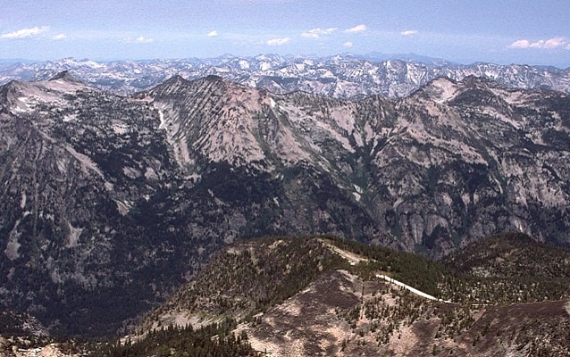
Photo by G Thomas
Quick Facts
Location:
From Lolo, MT to Weippe Prairie, ID
Significance:
Route taken by Corps of Discovery
Designation:
National Historic Landmark
Amenities
1 listed
Information
Lewis and Clark NHT Visitor Centers and Museums
This map shows a range of features associated with the Lewis and Clark National Historic Trail, which commemorates the 1803-1806 Lewis and Clark Expedition. The trail spans a large portion of the North American continent, from the Ohio River in Pittsburgh, Pennsylvania, to the mouth of the Columbia River in Oregon and Washington. The trail is comprised of the historic route of the Lewis and Clark Expedition, an auto tour route, high potential historic sites (shown in black), visitor centers (shown in orange), and pivotal places (shown in green). These features can be selected on the map to reveal additional information. Also shown is a base map displaying state boundaries, cities, rivers, and highways. The map conveys how a significant area of the North American continent was traversed by the Lewis and Clark Expedition and indicates the many places where visitors can learn about their journey and experience the landscape through which they traveled.
In mid-September 1805, the Lewis and Clark Expedition reached the historic Lolo Trail. The Corps knew the Lolo Trail would provide them a physical challenge, and they feared they would not survive the peaks without assistance. They were able to acquire as many horses as possible and enlist the help of a few guides who knew the route that lay ahead. Under the guidance of Old Toby (Shoshone), the Corps turned northward and began their ascent into the Bitterroot Mountains.
Over the course of 11 days they walked a 200-mile stretch of mountain terrain. They suffered from frostbite, malnutrition and dehydration. Clark noted, "I have been wet and as cold in every part as I ever was in my life, indeed I was at one time fearfull my feet would freeze in the thin Mockirsons which I wore" (DeVoto 1997, 240). They pushed forward, nearing the end of the Trail. Capturing the moment, Lewis wrote:
“. . . the pleasure I now felt in having tryumphed over the rockey Mountains and decending once more to a level and fertile country where there was every rational hope of finding a comfortable subsistence for myself and party can be more readily conceived than expressed, nor was the flattering prospect of the final success of the expedition less pleasing . . .”
Exhausted and starving, the men stumbled out of the Bitterroot Mountains and encountered the Nez Perce Indians at Weippe Prairie. On their return trip, the Corps of Discovery again traversed the Lolo Trail - this time taking 15 days.