Last updated: June 6, 2026
Place
Fort Churchill State Historic Park
NPS Photo
Quick Facts
Location:
Fort Churchill State Park, 10000 Hwy 95A, Silver Springs, Nevada 89429 GPS 39.294857 -119.267550.
Significance:
The US Army established Fort Churchill in July 1860 to protect emigrants, other travelers, local settlers and miners, and communications following the Pyramid Lake War. Pony Express riders picked up and delivered telegrams at fort headquarters, and nearby Buckland Station operated as a Pony Express home station for several months in 1860.
Designation:
Historic Site on the Pony Express and California NHTs.
MANAGED BY:
Amenities
14 listed
Accessible Sites, Cellular Signal, Grill, Historical/Interpretive Information/Exhibits, Parking - Auto, Parking - Bus/RV, Picnic Table, Restroom - Accessible, Scenic View/Photo Spot, Sewage Dump Station - Boat/RV, Tent Campsites, Trailhead, Water - Drinking/Potable, Wheelchair Accessible
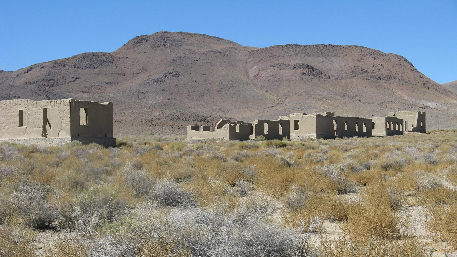
Fort Churchill stood on the north bank of the Carson River near the Sierra Nevada foothills, protecting travelers, settlements, and communication
routes from 1860 to 1869. Today, interpretive trails wind among its adobe ruins,
preserved in a state of “arrested decay,” and visitors picnic and camp on the old military grounds.
Now a peaceful state historic park and National Historic Landmark, Fort Churchill’s origins lie in violence. Tensions simmered for years as white settlement encroached on Native lands, boiling over into open warfare in May 1860. Accounts of the triggering event vary, but most accuse white traders from Williams Station of
assaulting Northern Paiute girls.
Warriors retaliated on May 6, killing the offenders and burning Williams Station.
Militias and US troops responded, leading to 2 battles and raiding by Northern Paiute, Shoshone, and Bannock war parties along the trails across Nevada and western Utah that summer. The conflict, later called the Pyramid Lake War, ended
with a cease-fire agreement in August 1860.
The Pony Express had launched barely a month before the war began and was forced to suspend operations for 44 days during the fighting. As hostilities
wound down, Pony Express owners, stagecoach men, and local settlers
demanded permanent military presence. In response, the US Army began
constructing Fort Churchill at the junction of the Pony Express Trail and the Carson Route of the California Trail, on the Carson River about 10 miles southeast of the ashes of Williams Station. The post was intended to protect roads, mail routes, telegraph lines, and local settlers and miners.
British traveler Sir Richard Burton visited in October 1860, describing Fort Churchill as “a well-disposed cantonment, containing quarters for the officers and barracks for the men.” He noted that although it housed only 2 companies of infantry, it “required at least 2,000 men.”
Pony Express riders delivered telegrams to the fort’s headquarters, but the post was never a Pony Express station. Instead, Samuel Buckland’s log-cabin store and saloon, 1 ½ miles east, served for a time as a Pony home station. Burton
complained of Buckland Station’s “vile…atmosphere of rum, knorshnapps, stable tobacco, flies, and profane oaths.”
After the transcontinental railroad was completed in 1869, the army vacated Fort Churchill. Buckland bought the post’s buildings at auction for $750 and salvaged
materials to build a 2-story home at his nearby ranch. The 1870 house, now listed on the National Register of Historic Places, is part of Fort Churchill State Park. Nothing
remains of the original Pony Express station that preceded it—nor of Williams Station, where the war was ignited. That site now lies beneath Lahontan Reservoir.
Hiking trails at the 3,200-acre park include a self-guided interpretive trail among the fort ruins and a nature trail along the Carson River. Exhibits at the recently refurbished visitor center explore site history.
Site Information
Location (Fort Churchill State Park, 10000 Hwy 95A, Silver Springs, Nevada 89429 GPS 39.294857 -119.267550.)