Last updated: May 30, 2023
Place
Beacon Rock
Quick Facts
MANAGED BY:
Amenities
1 listed
Scenic View/Photo Spot
Lewis and Clark NHT Visitor Centers and Museums
This map shows a range of features associated with the Lewis and Clark National Historic Trail, which commemorates the 1803-1806 Lewis and Clark Expedition. The trail spans a large portion of the North American continent, from the Ohio River in Pittsburgh, Pennsylvania, to the mouth of the Columbia River in Oregon and Washington. The trail is comprised of the historic route of the Lewis and Clark Expedition, an auto tour route, high potential historic sites (shown in black), visitor centers (shown in orange), and pivotal places (shown in green). These features can be selected on the map to reveal additional information. Also shown is a base map displaying state boundaries, cities, rivers, and highways. The map conveys how a significant area of the North American continent was traversed by the Lewis and Clark Expedition and indicates the many places where visitors can learn about their journey and experience the landscape through which they traveled.
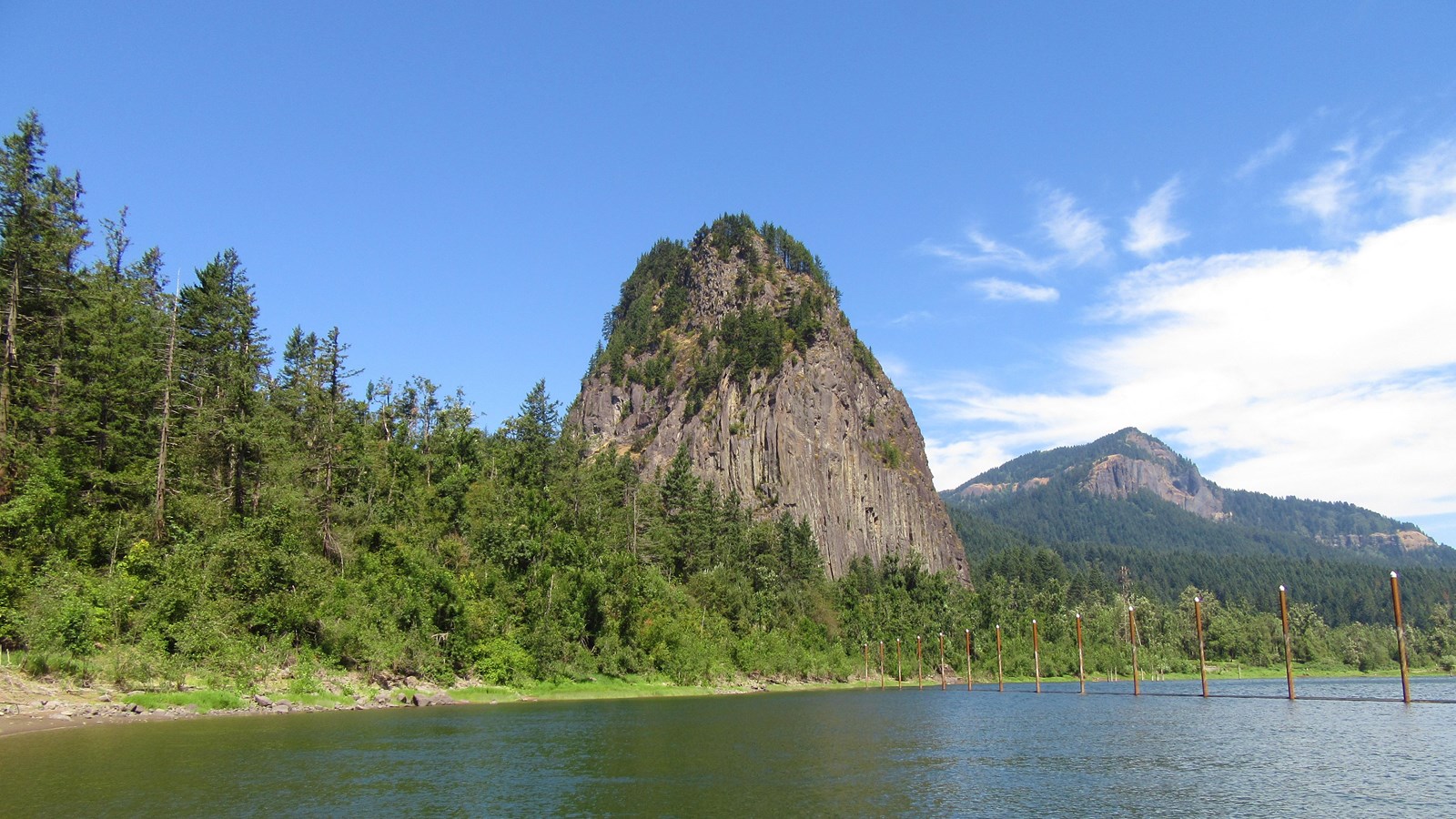
The core of an ancient volcano, Beacon Rock is essentially a basalt plug; the Missoula Flood waters eroded away the softer outer material. Captain Clark wrote in his journals, “…a remarkable high rock on Stard. Side about 800 feet high & 400 yds round…” His estimates were exceptionally close. Today, the site is on the Lewis and Clark National Historic Trail’s list of High Potential Historic Sites.
As the area was settled in the 19th century, the basalt feature was given a variety of names. By 1915, river developments threatened to destroy the rock. Henry J. Biddle, a prominent Washingtonian and descendant of Nicholas Biddle, the original editor of Lewis and Clark's journals, bought it and eventually gave it to the state for a park, restoring the original name assigned by Clark.
To get to the top, hike the mile-long switchback trail. Or for the more adventurous, you’ll enjoy rock climbing or hiking to waterfalls. Cyclists and horseback riders will find trails to outstanding vistas, and boaters will delight in the majesty of the area from the waters of the Columbia. The park includes 9,500 feet of freshwater shoreline and more than 26 miles of roads and trails. Picnicking and camping are also found at the park.
The park is open daily from 8 a.m. to dusk. A Washington State Park Discover Pass is required and may be purchased at an automated station. The park is just two miles from Skamania on state highway 14. For more information: http://parks.state.wa.us/474/Beacon-Rock.
Beacon Rock is a High Potential Historic Site on the Lewis and Clark National Historic Trail.
On October 31, 1805, Clark described, “a remarkable high detached rock Stands in a bottom on the Stard Side near the lower point of this Island on the Stard. Side about 800 feet high and 400 paces around, we call the Beaten rock.” Significantly, Clark also noted the first evidence of tidewater: “I could not See any rapids below in the extent of my view which was for a long distance down the river, which from the last rapids widened and had everry appearance of being effected by the tide.” The expedition revisited Beacon Rock returning upriver on April 6, 1806. Lewis wrote, “from the appearance of a rock […] I could judge better of the rise of the water than I could at any point below. I think the flood of this spring has been about 12 feet higher than it was [the previous fall]; the river is here about 1½ miles wide; it’s general width from the beacon rock which may be esteemed the head of tide water, to the marshey islands is from one to 2 miles tho’ in many places it is still wider. it is only in the fall of the year when the river is low that the tides are persceptable as high as the beacon rock. this remarkable rock which stands on the North shore of the river is unconnected with the hills and rises to the hight of seven hundred feet; […] it rises to a very sharp point and is visible for 20 miles below on the river.”
Beacon Rock is an eroded basalt volcanic plug that stands at approximately 848 feet. In the 1800s, it became known as Castle Rock. Purchased by Henry Biddle (a descendant of Nicholas Biddle) in 1915, he restored the Beacon Rock name, constructed a trail to the top, and donated it to the state of Washington. The landmark was designated a state park in 1935.