Last updated: January 26, 2023
Place
South Pass- Oregon Buttes

Historical/Interpretive Information/Exhibits, Scenic View/Photo Spot
A map of Passport and Places to Go locations for National Historic Trails.
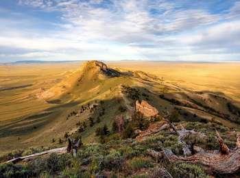
The Oregon Buttes consist of two flat-top hills and a smaller conical shaped hill. This landform, which is visible from South Pass, roughly marked the emigrants' entry into the Oregon Territory. Rising to an elevation of 8612 feet out of the northwestern portion of the Red Desert, they also made for a prominent landmark. To Oregon Trail travelers coming from the east, the buttes dominated the horizon for a day's travel or more as they crossed Rock Creek, then Willow Creek and, for a ninth and final time, the Sweetwater River.
Site Information
Location (the Oregon Buttes can be viewed from South Pass and Oregon Buttes Road. To explore the buttes, contact the Lander Field Office of the Bureau of Land Management)
Today, the buttes are covered with a wide variety of vegetation types including limber pine stands, thick aspen stands, and wet meadows. They are also located in a remote area that can be difficult to access and has few, if any, amenities and services.
More Site Information
Oregon National Historic Trail
