Last updated: June 26, 2026
Place
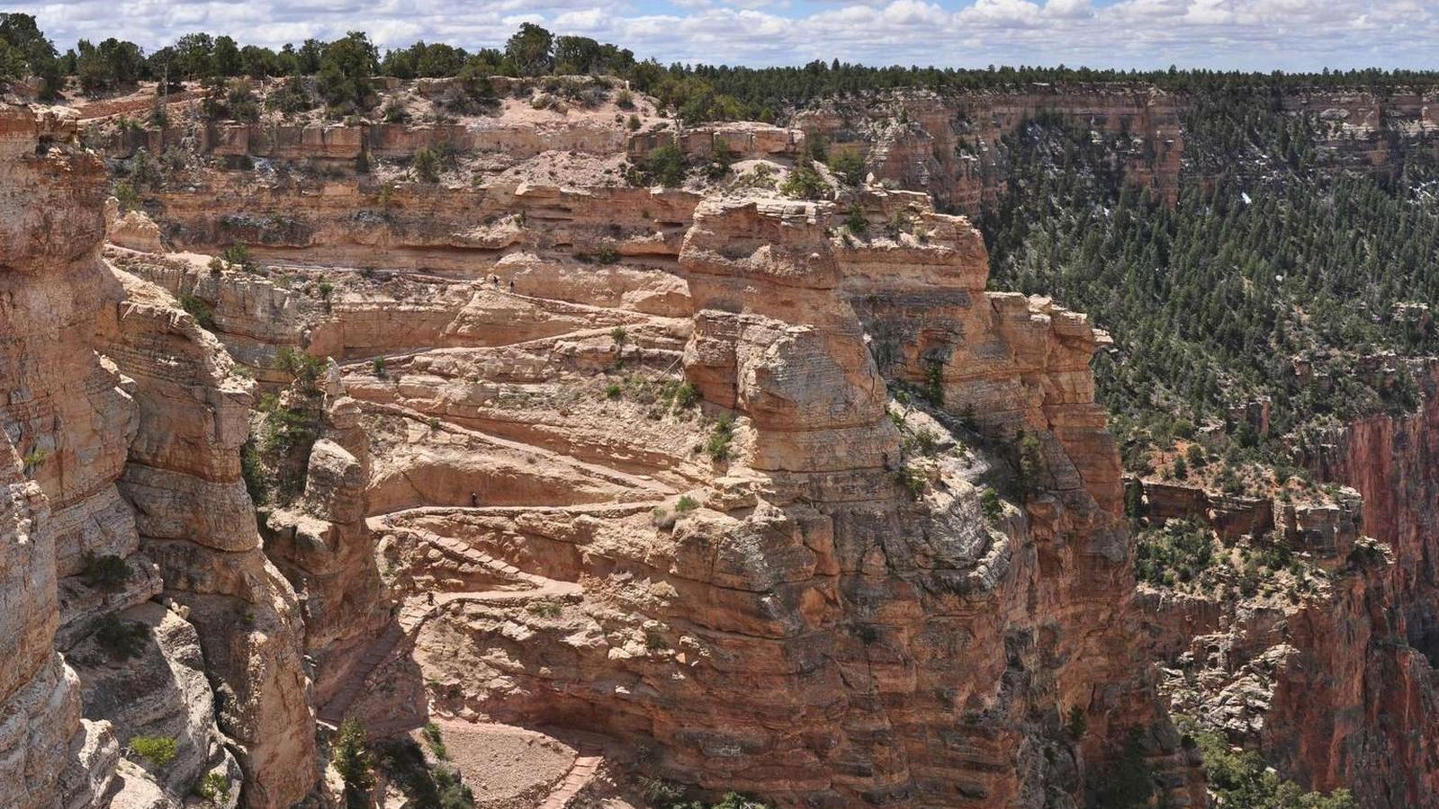
South Kaibab Trail
NPS/ M.Quinn
Quick Facts
Amenities
4 listed
Historical/Interpretive Information/Exhibits, Information, Information Kiosk/Bulletin Board, Trailhead
Know Before You Go
Before heading down into the canyon, consult the signs at the trailhead, and scan the QR code for trip planning, current weather, water availability, and trail information/closures. (or visit our Key Hiking Messages webpage).
Trail Status and Future Closures
CURRENTLY OPEN : (updated June 26, 2026)
- South Kaibab Trail from the South Kaibab Trailhead to Phantom Ranch.
- The Black Bridge crossing the Colorado River.
- Tonto Trail from Tipoff to Havasupai Gardens.
- Plateau Point Trail from the Tonto Trail junction to Plateau Point.
- Bright Angel Trail from the Bright Angel Trailhead to River Resthouse.
- The River Trail east of the River Resthouse to the South Kaibab Trail junction.
- The Silver Bridge.
- The entire North Kaibab Trail.
FUTURE CLOSURES — Beginning October 15, 2026:
- North Kaibab Trail from the Redwall Bridge (approximately 2.5 miles north of Manzanita Rest Area) to the northern end of Cottonwood Campground.
- NOTE: Traditional "Rim-to-Rim" hiking (North Rim to South Rim OR South Rim to North Rim) will not be possible beginning October 15, 2026.
Accessing South Kaibab Trailhead
Since there is no public parking at the South Kaibab Trailhead, please park at the Visitor Center, then take the Kaibab (Orange) Route shuttle bus to the trailhead. It is a 9-minute ride from the Visitor Center to the Trailhead. Current shuttle schedule.
-
If trail users need access to or from the South Kaibab Trailhead when the shuttle buses are not running, please contact Xanterra Taxi Service at 928.638.2631.
About South Kaibab Trail
The South Kaibab Trail is a well-defined, well-maintained dirt trail offering wonderful expansive views. This can be a great trail for short trips into the canyon of half a day or less, but the openness of this trail lends itself to extreme heat during the summer months and little to no protection from passing storms.
There is little shade, and what is there comes mostly from the canyon walls at the very beginning of the trail in the early part of day.
There is no water along the trail, though there is a spring-fed water filling station at the trailhead during the summer.
No private vehicles allowed at the trailhead. Access is by foot, bicycle, or shuttle bus only.
*Note: all trails into the canyon are steep and difficult; consider contacting a park ranger before starting your hike.
Destinations:
Ooh Aah Point
1.8 miles (2.9 km) roundtrip / 1-2 hours / 790 feet (230 m) elevation change
Cedar Ridge
3 miles (4.8 km) roundtrip / 2-4 hours / 1,120 feet (340 m) elevation change
Skeleton Point - Check with a park ranger before attempting as a day hike.
6 miles (9.6 km) roundtrip / 4-6 hours / 2,040 feet (620 m) elevation change
Hiking below Skeleton Point is not recommended as a day hike due to the long distance, extreme temperature changes, and an approximately 5,000-foot (1,500 m) elevation change each way. Consult a park ranger before heading further down for safety tips and overnight permits.
The Tipoff
9 miles (14.5 km) roundtrip / 6-9 hours / 3,280 feet (1,100 m) elevation change
Phantom Ranch
15 miles (24 km) roundtrip / 2 days / 4,700 ft (1,430 m) elevation change
Water
There is no water on the South Kaibab Trail. Water at the South Kaibab Trailhead is currently OFF due to a localized pipeline break.
Potable water is available year round at Bright Angel Campground, however, please note that due to occasional pipeline breaks water at Bright Angel Campground is not guaranteed: bringing an alternative form of water treatment, such as iodine tablets or a water filter, is essential. During hot weather, take at least 4 liters of water.
Trail Description
Hikers seeking panoramic views unparalleled on any other trail at Grand Canyon will want to consider a hike down the South Kaibab Trail. It is the only trail at Grand Canyon National Park that so dramatically holds true to a ridgeline descent. But this exhilarating sense of exposure to the vastness of the canyon comes at a cost: there is little shade and no water for the length of this trail.
During winter months, the constant sun exposure is likely to keep most of the trail relatively free of ice and snow. For those who insist on hiking during summer months, which is not recommended in general, this trail is the quickest way to the bottom (it has been described as "a trail in a hurry to get to the river"), but due to lack of any water sources, ascending the trail can be a dangerous proposition.
Access
Hikers must use the park's free shuttle bus system to reach the trailhead. Every morning, three hiker express buses leave from the Bright Angel Lodge and then from the Backcountry Information Center (times vary depending on the month). Otherwise, hikers will need to park at Grand Canyon Visitor Center and take the South Kaibab (Orange) shuttle bus.
Hike Smart
Make a Plan
Once you have researched your trip and are confident in what to expect on the trail, communicate your plan to someone who will notice if you are overdue and report it to 911.
Check the Weather
Summer temperatures in the shade routinely pass 100°F (38°C). Avoid hiking between 10 am and 4 pm, the hottest times of day.
From July to September, monsoons can build large, violent lightning storms. Seek shelter immediately.
In winter and early spring, temperatures can drop below 32°F (0°C) and upper portions of this steep trail become dangerously icy. Hard ice often conceals potentially hazardous passages. Over-the-shoe traction devices are highly recommended.
Pack Properly
It is critical to determine before your hike your needs for fluids and for snacks high in calories and salts. Consuming twice as many calories as during normal exercise is realistic for summer canyon hikes. The hike out of the canyon will likely take twice as long as the hike down. Wearing sun hats and cool, wet clothing will help regulate your core body temperature during warmer hikes.
Energy Balance
Your body needs energy-balancing proper nutrition and hydration are critical to your hiking success! Eat and drink while resting-sip fluids only when thirsty.
Too little water leads to dehydration and heat stroke. Excessive hydration and insufficient salt intake causes hyponatremia a seizure-producing electrolyte disorder. If you do not feel well: seek shade, get wet, cool off, eat, and rest. Turning around may be your best option.
Mules and Hikers
Mules use this trail regularly.
Expect to encounter aromatic evidence of them on your hike!
Always give mules the right of way.
Encounters between hikers and mules have resulted in injuries to packers and the death to mules. To ensure safety for yourself, other trail users, mules, and mule riders, follow these steps when encountering mules on the trails:
-
Step off the trail on the uphill side-away from the edge.
-
Listen for and follow the direction of the wrangler.
-
Remain completely quiet and stand perfectly still.
-
Only return to the trail when the last mule is 50 feet (15 m) beyond your position.
Camping
A permit is required for backcountry camping in this area. Learn more and how to apply online —or if you are visiting the South Rim, check with a ranger at the Backcountry Information Center,
Bright Angel Campground. Located on the north side of the Colorado River Bright Angel Campground offers 30 small group sites and 2 large group sites.